
Home / Novel Remote Sensing Approaches: Monitoring Seismic Changes
After an earthquake, the rapid, accurate, and comprehensive information regarding the locations of damaged buildings forms the basis for many stages in disaster management, resource allocation for emergency response, temporary sheltering, debris removal, and even reconstruction. In recent years, the use of very high-resolution optical (and radar) satellite images has become one of the primary sources of information. Nowadays, visual (operational) analysis of optical images from affected areas and the provision of initial damage maps in urban and rural earthquakes are common practices. To speed up and improve the accuracy of these maps and to create related systems, automatic extraction of buildings and estimation of seismic damage have become a subject of exciting and highly applicable research using satellite image processing methods.
With the availability of very high spatial resolution satellite data and images starting in the early 2000s, the development of remote sensing technology for civilian applications, such as detecting surface changes and identifying and classifying land features, especially in urban and rural areas, has rapidly accelerated. Remote sensing technology has made it possible to capture details with a spatial resolution of a few decimeters from distances of about 600 kilometers above the Earth. The revisit time (or temporal resolution) between two corresponding observations of a specific location on Earth can range from 16 days (for global monitoring from about 600 kilometers) to a fraction of a day (for dedicated systems). Countries with advanced satellite technology have been able to deploy constellations of identical satellites to continuously and regularly monitor regions of interest for natural disasters, such as earthquakes.
The capabilities in developing image processing methods and performing image analysis in the Remote Sensing Group of the International Institute of Earthquake Engineering and Seismology can be summarized as follows. After preprocessing operations (such as georeferencing, image registration, histogram enhancement), various methods in image fusion, image segmentation, texture analysis, model and algorithm development, and the application of soft computing methods (i,e, artificial neural networks, genetic algorithms, support vector machines, fuzzy logic, and combinations of these schemes) can be used for detecting changes and assessing damage in urban and rural areas. Recently, based on the augmented databases concerning the features in the built environment and the ability to perform complex and parallel computations in a short time, the development of modern deep learning methods concerning building extraction and providing highly efficient damage maps has become feasible. This research is considered cutting-edge.
One of the successes achieved has been the integration and use of multi-sensor, multi-platform images, which allows for the use of data from various sensors before and after an event. The development of such algorithms has leveraged the lack of data to some extent. This is especially useful when pre-event data of a particular sensor is unavailable, and some other baseline data (pre-event) from other sensors can be utilized instead (multi-sensor approaches). Another successful approach has been the solely use of single post-event images. By preparing ground truth data obtained from various patterns and different sensors, valuable baseline information has been created for urban or rural settings for different parts of the country. This developed domestic database, compared to similar global ones, is unique in terms of quantity and quality. For example, in the production of damage maps (widespread destruction and total collapse), using soft computing methods, and in a very short time (a few hours, including preprocessing and image corrections, etc.) after accessing satellite images (or UAV images …), the overall accuracy of the product has been around 75%, and when utilizing some deep learning methods, the accuracy exceeded 90% in overall. It should be noted that in the field of disaster management, particularly in the early phases of emergency response, these accuracies are considered excellent and highly effective. These results are particularly vital and insightful for organizations involved, such as the Disaster Management Organization and the Red Crescent Society.
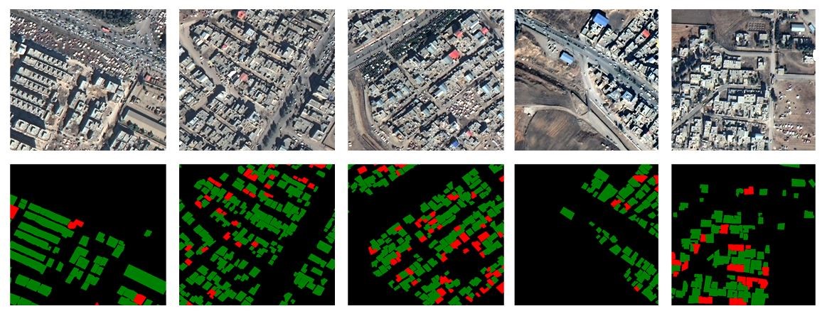
Figure 3: Damage map from deep learning analyses (2017 Sarpol-e Zahab Earthquake)
(From: mitechnews.com)
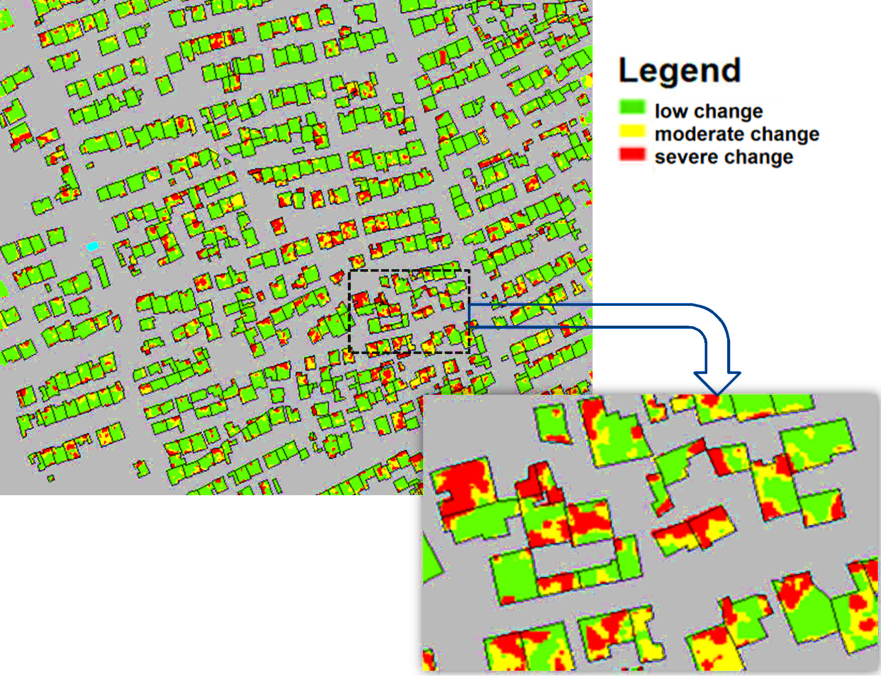
Figure 1: Damage map from soft computing analyses (2003 Bam Earthquake)
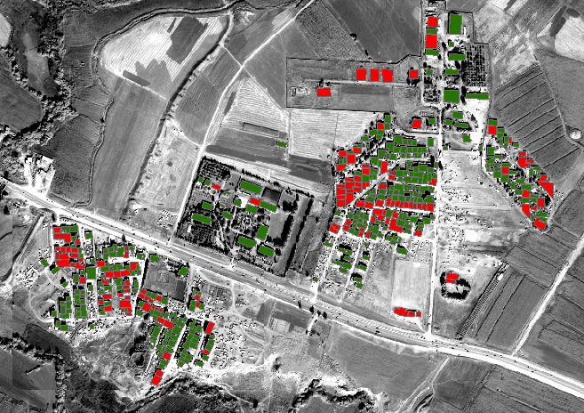
Figure 2: Damage map from soft computing analyses (2017 Sarpol-e Zahab Earthquake)