
Magnitude |
2.7 |
| Date & Time (UTC) | 2015-07-23 07:32:22.9 |
| Date & Time (Local) | 1394/5/1 12:02:22.9 |
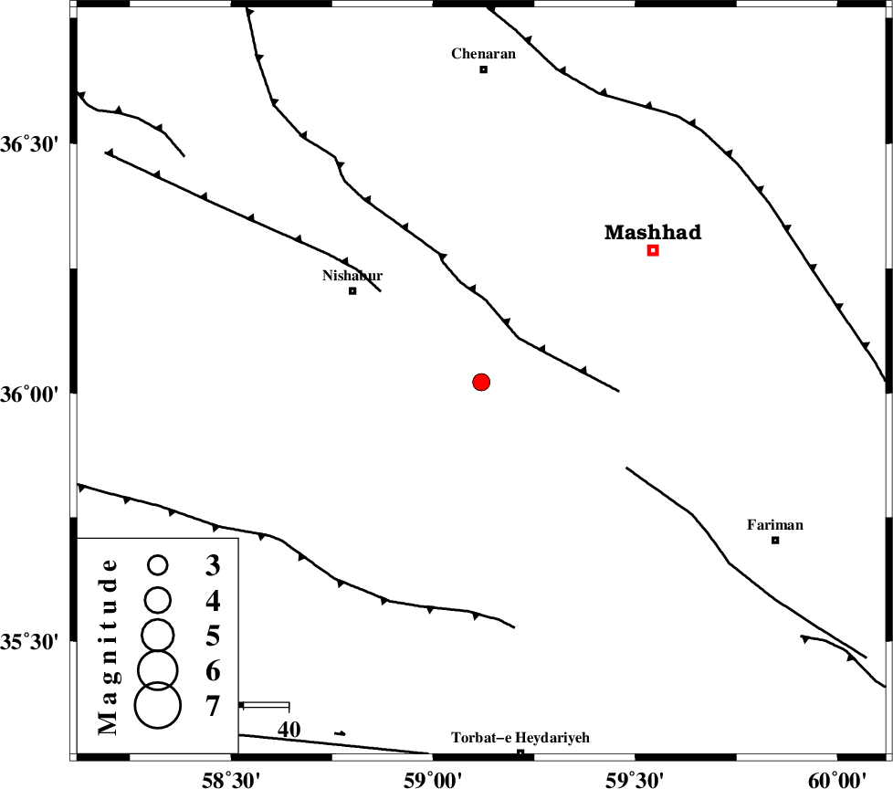
| Location | Lat:36.022 Lon: 59.119 |
| Region | Khorasan(center) Province, 35 km South-East of Neyshabur |
Nearest Cities |
|
| 11 km East of Eshaqabad, Khorasan(center) Province | |
| 13 km South of Darrud, Khorasan(center) Province | |
| 25 km South East of Abusaeedi, Khorasan(center) Province | |
| 32 km North West of Emamtaqi, Khorasan(center) Province | |
| 35 km South East of Neyshabur, Khorasan(center) Province | |
| Depth | 15 km |
| Agency | |
Faults within 150 km: |
|
| BINALUD_F1 (Length: 129 km) , Distance to epicenter: 13 km | |
| NAYSHABUR_F (Length: 74 km) , Distance to epicenter: 30 km | |
| TORBAT_E_JAM_F1 (Length: 71 km) , Distance to epicenter: 37 km | |
| Number of Phases | 4 |
| RMS | 0.5 |
| Number of Stations | 4 |
| Error in Latitude | >9.4 km |
| Error in Longitude | 4.8 km |
| Error in Depth | 0 km |
Download waveform in seisan format
to download seisan software Click here
to access information about IIEES stations Click here
Amplitude | ||||||||
| UID | Agency | Station | Component | Amplitude | Period | Arrival Time | Proccessing Time | Signal Clip |
| 100169 | IIEES | SHRO | N | 34 | 0.32 | 2015-07-23 07:33:43 | 2015-07-25 11:55:00 | n |
| 100170 | IIEES | SHRO | E | 36.8 | 0.42 | 2015-07-23 07:33:44 | 2015-07-25 11:55:00 | n |
Phase | ||||||||||||
| Agency | Station | Component | Phase Type | Phase Quality | First Motion | Observed Arrival Time | Time Residual | Loc. Flag | Input Weight | Distance | Azimuth | |
| IIEES | BJRD | Z | Pn | E | 2015-07-23 07:33:00 | 0.48 | y | 241 | 321 | |||
| IIEES | SHRO | Z | Pn | E | 2015-07-23 07:33:05 | 0.29 | y | 280 | 271 | |||
| IIEES | SHRT | Z | Pn | E | 2015-07-23 07:33:05 | -0.04 | y | 285 | 158 | |||
| IIEES | MRVT | Z | Pn | E | 2015-07-23 07:33:10 | -0.81 | y | 326 | 305 | |||