
Magnitude |
3.1 |
| Date & Time (UTC) | 2015-07-29 06:56:43.0 |
| Date & Time (Local) | 1394/5/7 11:26:43.0 |
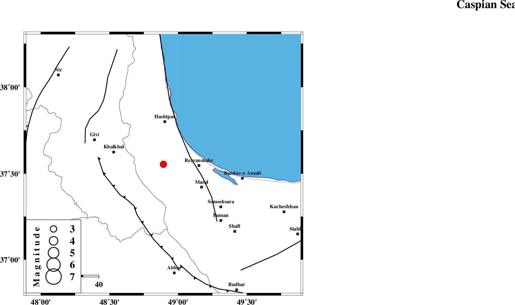
| Location | Lat:37.554 Lon: 48.893 |
| Region | Gilan Province, 27 km South of Hashtpar |
Nearest Cities |
|
| 1 km North of Ardeh, Gilan Province | |
| 16 km West of Parrehsar, Gilan Province | |
| 17 km West of Void, Gilan Province | |
| 21 km North West of Shangavar, Gilan Province | |
| 22 km South of Tularud, Gilan Province | |
| Depth | 14 km |
| Agency | |
Faults within 150 km: |
|
| TALESH_F (Length: 258 km) , Distance to epicenter: 18 km | |
| MASULEL_F (Length: 90 km) , Distance to epicenter: 33 km | |
| SANGAVAR_F (Length: 61 km) , Distance to epicenter: 52 km | |
| Number of Phases | 6 |
| RMS | 0.2 |
| Number of Stations | 4 |
| Error in Latitude | >2.8 km |
| Error in Longitude | 5 km |
| Error in Depth | 5.7 km |
Download waveform in seisan format
to download seisan software Click here
to access information about IIEES stations Click here
Amplitude | ||||||||
| UID | Agency | Station | Component | Amplitude | Period | Arrival Time | Proccessing Time | Signal Clip |
| 100207 | IIEES | GRMI | N | 216.9 | 0.26 | 2015-07-29 06:57:31 | 2015-07-29 09:10:00 | n |
| 100208 | IIEES | GRMI | E | 272 | 0.18 | 2015-07-29 06:57:31 | 2015-07-29 09:10:00 | n |
Phase | ||||||||||||
| Agency | Station | Component | Phase Type | Phase Quality | First Motion | Observed Arrival Time | Time Residual | Loc. Flag | Input Weight | Distance | Azimuth | |
| IIEES | ZNJK | Z | Pg | E | 2015-07-29 06:56:59 | -0.14 | y | 99.7 | 191 | |||
| IIEES | GRMI | Z | Pg | E | 2015-07-29 06:57:10 | 0.02 | y | 165 | 328 | |||
| IIEES | GRMI | N | Sg | E | 2015-07-29 06:57:30 | -0.11 | y | 165 | 328 | |||
| IIEES | THKV | Z | Pn | E | 2015-07-29 06:57:22 | 0.32 | y | 254 | 135 | |||
| IIEES | THKV | N | Sg | E | 2015-07-29 06:57:54 | -0.28 | y | 254 | 135 | |||
| IIEES | ASAO | Z | Pn | E | 2015-07-29 06:57:34 | 0.23 | y | 349 | 163 | |||