
Magnitude |
2.2 |
| Date & Time (UTC) | 2015-08-09 16:03:03.4 |
| Date & Time (Local) | 1394/5/18 20:33:03.4 |
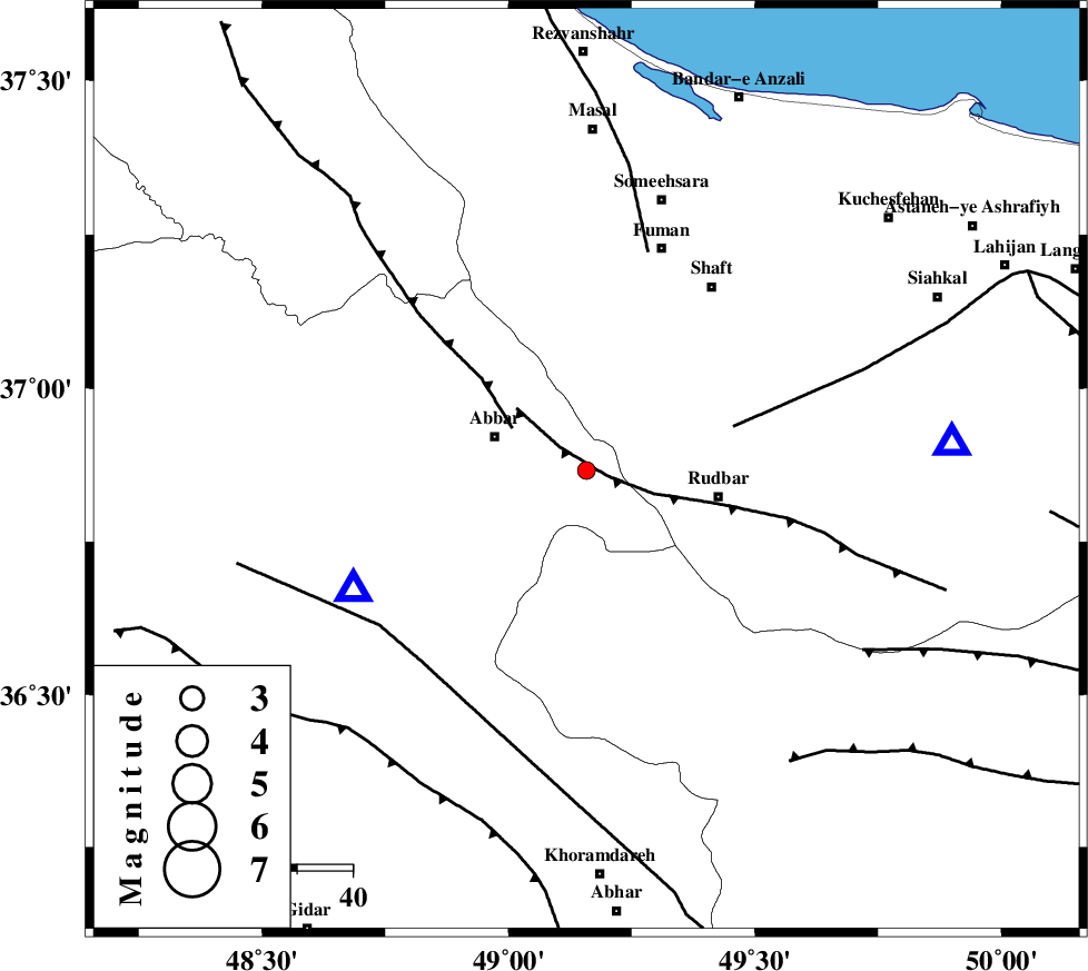
| Location | Lat:36.866 Lon: 49.158 |
| Region | Zanjan Province, 18 km -East of Abbar |
Nearest Cities |
|
| 16 km North East of Void, Zanjan Province | |
| 18 km East of Abbar, Zanjan Province | |
| 21 km South of Siyahmargi, Gilan Province | |
| 23 km South of Qaleh rudkhan, Gilan Province | |
| 24 km North West of Rudbar, Gilan Province | |
| Depth | 37 km |
| Agency | |
Faults within 150 km: |
|
| RUDBAR_F (Length: 93 km) , Distance to epicenter: 4 km | |
| MASULEL_F (Length: 90 km) , Distance to epicenter: 15 km | |
| LAHIJAN_F (Length: 92 km) , Distance to epicenter: 28 km | |
| Number of Phases | 5 |
| RMS | 0.1 |
| Number of Stations | 4 |
| Error in Latitude | >8.9 km |
| Error in Longitude | 3.3 km |
| Error in Depth | 3.4 km |
Download waveform in seisan format
to download seisan software Click here
to access information about IIEES stations Click here
Amplitude | ||||||||
| UID | Agency | Station | Component | Amplitude | Period | Arrival Time | Proccessing Time | Signal Clip |
| 100283 | IIEES | ZNJK | E | 167.7 | 0.09 | 2015-08-09 16:03:21 | 2015-08-10 05:34:00 | n |
| 100284 | IIEES | ZNJK | N | 150.4 | 0.15 | 2015-08-09 16:03:21 | 2015-08-10 05:34:00 | n |
Phase | ||||||||||||
| Agency | Station | Component | Phase Type | Phase Quality | First Motion | Observed Arrival Time | Time Residual | Loc. Flag | Input Weight | Distance | Azimuth | |
| IIEES | ZNJK | Z | Pg | E | 2015-08-09 16:03:13 | 0.11 | y | 47.5 | 243 | |||
| IIEES | ZNJK | E | Sg | E | 2015-08-09 16:03:20 | -0.1 | y | 47.5 | 243 | |||
| IIEES | THKV | Z | P | E | 2015-08-09 16:03:32 | -0.13 | y | 187 | 124 | |||
| IIEES | CHTH | Z | Pg | E | 2015-08-09 16:03:36 | 0.03 | y | 206 | 120 | |||
| IIEES | ASAO | Z | Pn | E | 2015-08-09 16:03:42 | 0.08 | y | 269 | 163 | |||