
Magnitude |
3.1 |
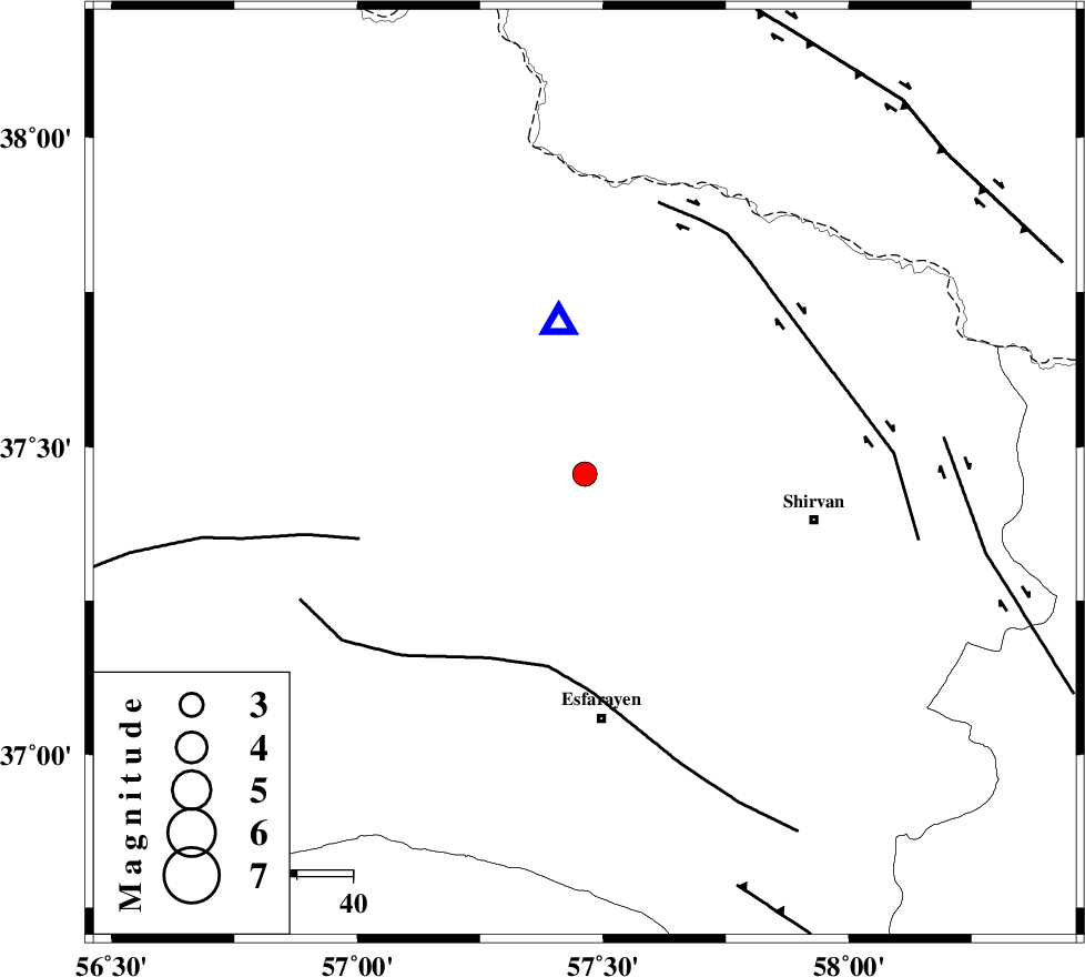
| Date & Time (UTC) | 2015-08-22 14:00:37.7 |
| Date & Time (Local) | 1394/5/31 18:30:37.7 |
| Location | Lat:37.456 Lon: 57.463 |
| Region | Khorasan(north) Province, 12 km -East of Bojnurd |
Nearest Cities |
|
| 7 km of Hesar-egarmkhanh, Khorasan(north) Province | |
| 12 km East of Void, Khorasan(north) Province | |
| 12 km East of Bojnurd, Khorasan(north) Province | |
| 29 km North West of Zavarom, Khorasan(north) Province | |
| 35 km South West of Tukur, Khorasan(north) Province | |
| Depth | 15 km |
| Agency | |
Faults within 150 km: |
|
| ESFARAYEN_F (Length: 111 km) , Distance to epicenter: 35 km | |
| ROBATE_QARABIL_F (Length: 168 km) , Distance to epicenter: 42 km | |
| BAGHAN_GERMAB_F (Length: 79 km) , Distance to epicenter: 47 km | |
| Number of Phases | 7 |
| RMS | 0.3 |
| Number of Stations | 6 |
| Error in Latitude | >3.6 km |
| Error in Longitude | 6.1 km |
| Error in Depth | 8.2 km |
Download waveform in seisan format
to download seisan software Click here
to access information about IIEES stations Click here
Amplitude | ||||||||
| UID | Agency | Station | Component | Amplitude | Period | Arrival Time | Proccessing Time | Signal Clip |
| 100431 | IIEES | MRVT | E | 295.8 | 0.31 | 2015-08-22 14:01:20 | 2015-08-23 07:22:00 | n |
| 100432 | IIEES | MRVT | N | 288.8 | 0.25 | 2015-08-22 14:01:22 | 2015-08-23 07:22:00 | n |
| 100433 | IIEES | SHRO | E | 298.1 | 0.6 | 2015-08-22 14:01:37 | 2015-08-23 07:22:00 | n |
Phase | ||||||||||||
| Agency | Station | Component | Phase Type | Phase Quality | First Motion | Observed Arrival Time | Time Residual | Loc. Flag | Input Weight | Distance | Azimuth | |
| IIEES | BJRD | Z | Pg | E | 2015-08-22 14:00:43 | 0.09 | y | 27.5 | 350 | |||
| IIEES | MRVT | Z | Pg | E | 2015-08-22 14:00:58 | -0.2 | y | 123 | 281 | |||
| IIEES | SHRO | Z | Pn | E | 2015-08-22 14:01:11 | 0.36 | y | 206 | 219 | |||
| IIEES | SHRO | E | Sg | E | 2015-08-22 14:01:36 | 0.07 | y | 206 | 219 | |||
| IIEES | TABS | Z | Pn | E | 2015-08-22 14:01:37 | -0.46 | y | 423 | 184 | |||
| IIEES | SHRT | Z | Pn | E | 2015-08-22 14:01:47 | 0.26 | y | 494 | 148 | |||
| IIEES | BSRN | Z | Pn | E | 2015-08-22 14:02:03 | -0.28 | y | 628 | 165 | |||