
Magnitude |
2.7 |
| Date & Time (UTC) | 2015-08-26 17:02:18.4 |
| Date & Time (Local) | 1394/6/4 21:32:18.4 |
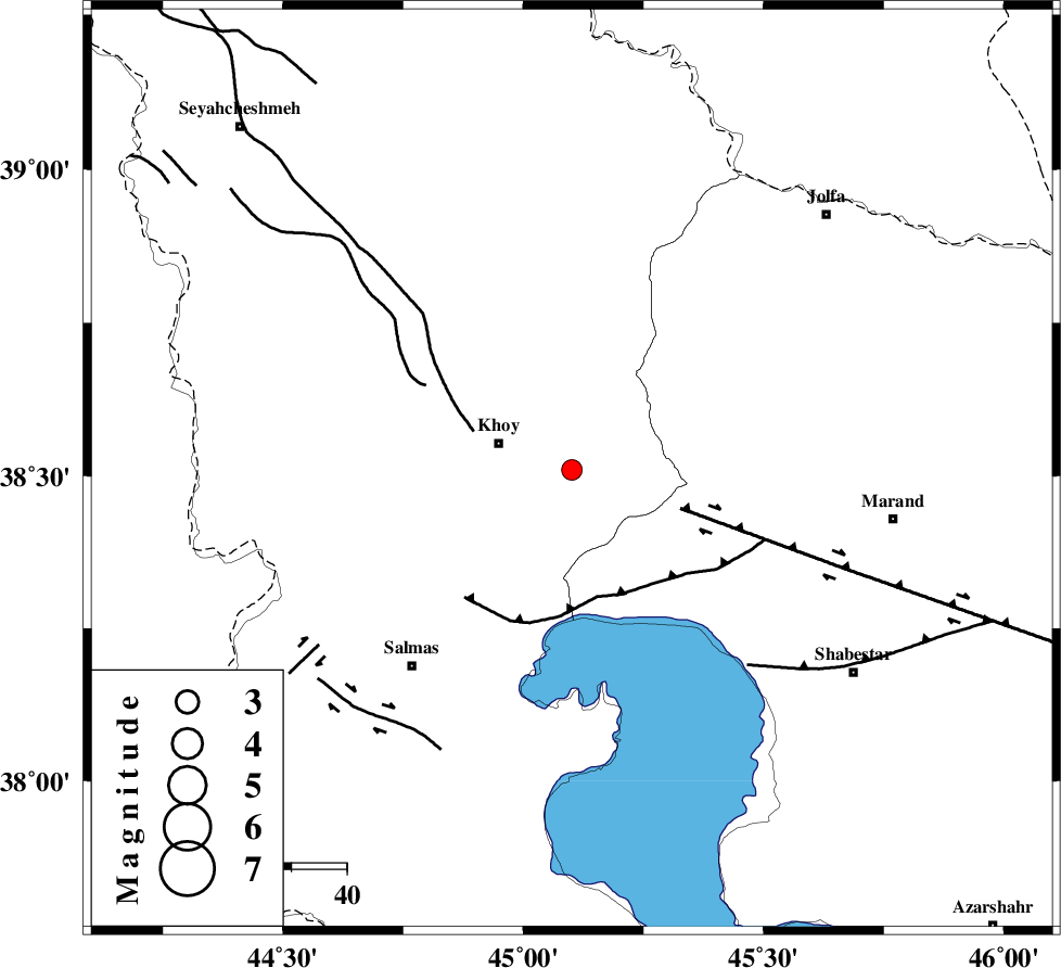
| Location | Lat:38.51 Lon: 45.101 |
| Region | Azarbaijan Gharbi Province, 14 km -East of Khoy |
Nearest Cities |
|
| 8 km North of Dizaj diz, Azarbaijan Gharbi Province | |
| 9 km of Saeedabad, Azarbaijan Gharbi Province | |
| 14 km East of Khoy, Azarbaijan Gharbi Province | |
| 17 km North East of Quruq, Azarbaijan Gharbi Province | |
| 20 km South East of Dizaj, Azarbaijan Gharbi Province | |
| Depth | 18 km |
| Agency | |
Faults within 150 km: |
|
| KHOY (Length: 100 km) , Distance to epicenter: 19 km | |
| N_TABRIZ_F1 (Length: 222 km) , Distance to epicenter: 21 km | |
| N_TABRIZ_F3 (Length: 66 km) , Distance to epicenter: 23 km | |
| Number of Phases | 5 |
| RMS | 0.2 |
| Number of Stations | 3 |
| Error in Latitude | >5.7 km |
| Error in Longitude | 3.9 km |
| Error in Depth | 8.4 km |
Download waveform in seisan format
to download seisan software Click here
to access information about IIEES stations Click here
Amplitude | ||||||||
| UID | Agency | Station | Component | Amplitude | Period | Arrival Time | Proccessing Time | Signal Clip |
| 100607 | IIEES | ZNJK | N | 18.7 | 0.48 | 2015-08-26 17:04:10 | 2015-08-30 11:02:00 | n |
| 100608 | IIEES | ZNJK | E | 17.9 | 0.32 | 2015-08-26 17:04:12 | 2015-08-30 11:02:00 | n |
Phase | ||||||||||||
| Agency | Station | Component | Phase Type | Phase Quality | First Motion | Observed Arrival Time | Time Residual | Loc. Flag | Input Weight | Distance | Azimuth | |
| IIEES | MAKU | Z | Pg | E | 2015-08-26 17:02:35 | 0.24 | y | 101 | 339 | |||
| IIEES | MAKU | N | Sg | E | 2015-08-26 17:02:47 | -0.14 | y | 101 | 339 | |||
| IIEES | GRMI | Z | Pn | E | 2015-08-26 17:02:56 | -0.17 | y | 245 | 81 | |||
| IIEES | GRMI | N | Sg | E | 2015-08-26 17:03:27 | 0.08 | y | 245 | 81 | |||
| IIEES | ZNJK | Z | Pn | E | 2015-08-26 17:03:12 | -0.01 | y | 377 | 122 | |||

 IIEES All Rights Reserved