
Magnitude |
3.2 |
| Date & Time (UTC) | 2015-10-19 20:30:15.3 |
| Date & Time (Local) | 1394/7/28 00:00:15.3 |
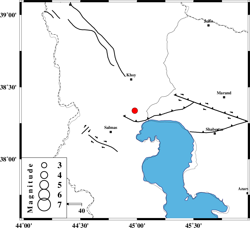
| Location | Lat:38.337 Lon: 44.98 |
| Region | Azarbaijan Gharbi Province, 24 km South of Khoy |
Nearest Cities |
|
| 11 km North of Qareh qeshlaq, Azarbaijan Gharbi Province | |
| 13 km South of Quruq, Azarbaijan Gharbi Province | |
| 15 km South of Dizaj diz, Azarbaijan Gharbi Province | |
| 20 km North East of Saylab, Azarbaijan Gharbi Province | |
| 24 km South of Khoy, Azarbaijan Gharbi Province | |
| Depth | 17 km |
| Agency | |
Faults within 150 km: |
|
| N_TABRIZ_F3 (Length: 66 km) , Distance to epicenter: 8 km | |
| KHOY (Length: 100 km) , Distance to epicenter: 27 km | |
| N_TABRIZ_F1 (Length: 222 km) , Distance to epicenter: 33 km | |
| Number of Phases | 6 |
| RMS | 0.1 |
| Number of Stations | 4 |
| Error in Latitude | >4.7 km |
| Error in Longitude | 7.3 km |
| Error in Depth | 5.3 km |
Download waveform in seisan format
to download seisan software Click here
to access information about IIEES stations Click here
Amplitude | ||||||||
| UID | Agency | Station | Component | Amplitude | Period | Arrival Time | Proccessing Time | Signal Clip |
| 101903 | IIEES | ZNJK | N | 53 | 0.53 | 2015-10-19 20:32:09 | 2015-10-20 06:02:00 | n |
| 101904 | IIEES | ZNJK | E | 52.9 | 0.11 | 2015-10-19 20:32:14 | 2015-10-20 06:02:00 | n |
Phase | ||||||||||||
| Agency | Station | Component | Phase Type | Phase Quality | First Motion | Observed Arrival Time | Time Residual | Loc. Flag | Input Weight | Distance | Azimuth | |
| IIEES | MAKU | Z | Pg | E | 2015-10-19 20:30:35 | 0.09 | y | 116 | 347 | |||
| IIEES | MAKU | E | Sg | E | 2015-10-19 20:30:49 | -0.08 | y | 116 | 347 | |||
| IIEES | ZNJK | Z | Pn | E | 2015-10-19 20:31:09 | 0.03 | y | 376 | 118 | |||
| IIEES | ZNJK | E | Sg | E | 2015-10-19 20:32:00 | -0.01 | y | 376 | 118 | |||
| IIEES | ASAO | Z | Pn | E | 2015-10-19 20:31:39 | -0.11 | y | 617 | 131 | |||
| IIEES | MRVT | Z | Pn | E | 2015-10-19 20:32:24 | 0.2 | y | 978 | 91 | |||

 IIEES All Rights Reserved