
Magnitude |
2.6 |
| Date & Time (UTC) | 2016-07-10 22:03:40.9 |
| Date & Time (Local) | 1395/4/21 02:33:40.9 |
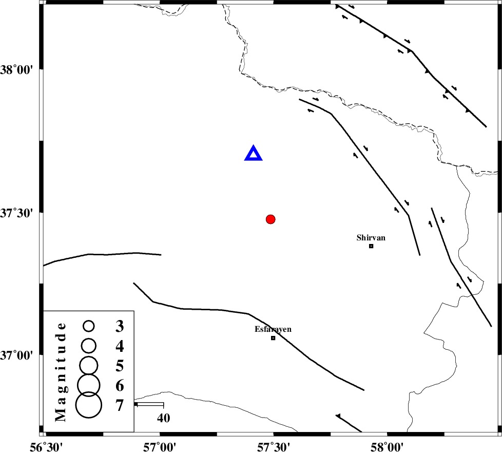
| Location | Lat:37.476 Lon: 57.486 |
| Region | Khorasan(north) Province, 14 km -East of Bojnurd |
Nearest Cities |
|
| 4 km of Hesar-egarmkhanh, Khorasan(north) Province | |
| 14 km North East of Void, Khorasan(north) Province | |
| 14 km North East of Bojnurd, Khorasan(north) Province | |
| 28 km North West of Zavarom, Khorasan(north) Province | |
| 32 km South West of Tukur, Khorasan(north) Province | |
| Depth | 14 km |
| Agency | |
Faults within 150 km: |
|
| ESFARAYEN_F (Length: 111 km) , Distance to epicenter: 38 km | |
| BAGHAN_GERMAB_F (Length: 79 km) , Distance to epicenter: 44 km | |
| ROBATE_QARABIL_F (Length: 168 km) , Distance to epicenter: 45 km | |
| Number of Phases | 7 |
| RMS | 0.2 |
| Number of Stations | 5 |
| Error in Latitude | >3 km |
| Error in Longitude | 5.7 km |
| Error in Depth | 7 km |
Download waveform in seisan format
to download seisan software Click here
to access information about IIEES stations Click here
Amplitude | ||||||||
| UID | Agency | Station | Component | Amplitude | Period | Arrival Time | Proccessing Time | Signal Clip |
| 107487 | IIEES | BJRD | N | 865.1 | 0.24 | 2016-07-10 22:03:51 | 2016-07-11 06:25:00 | n |
| 107488 | IIEES | MRVT | E | 141.1 | 0.34 | 2016-07-10 22:04:23 | 2016-07-11 06:25:00 | n |
| 107489 | IIEES | MRVT | N | 124.1 | 0.32 | 2016-07-10 22:04:24 | 2016-07-11 06:25:00 | n |
Phase | ||||||||||||
| Agency | Station | Component | Phase Type | Phase Quality | First Motion | Observed Arrival Time | Time Residual | Loc. Flag | Input Weight | Distance | Azimuth | |
| IIEES | BJRD | Z | Pg | E | 2016-07-10 22:03:46 | 0.04 | y | 25.8 | 345 | |||
| IIEES | BJRD | N | Sg | E | 2016-07-10 22:03:50 | 0.03 | y | 25.8 | 345 | |||
| IIEES | MRVT | Z | Pg | E | 2016-07-10 22:04:01 | -0.22 | y | 125 | 280 | |||
| IIEES | SHRO | Z | Pn | E | 2016-07-10 22:04:15 | 0.38 | y | 209 | 219 | |||
| IIEES | SHRO | N | Sg | E | 2016-07-10 22:04:40 | 0.03 | y | 209 | 219 | |||
| IIEES | TABS | Z | Pn | E | 2016-07-10 22:04:41 | -0.38 | y | 426 | 185 | |||
| IIEES | SHRT | Z | Pn | E | 2016-07-10 22:04:50 | 0.03 | y | 495 | 148 | |||

 IIEES All Rights Reserved