
Magnitude |
2.5 |
| Date & Time (UTC) | 2016-07-14 07:01:22.7 |
| Date & Time (Local) | 1395/4/24 11:31:22.7 |
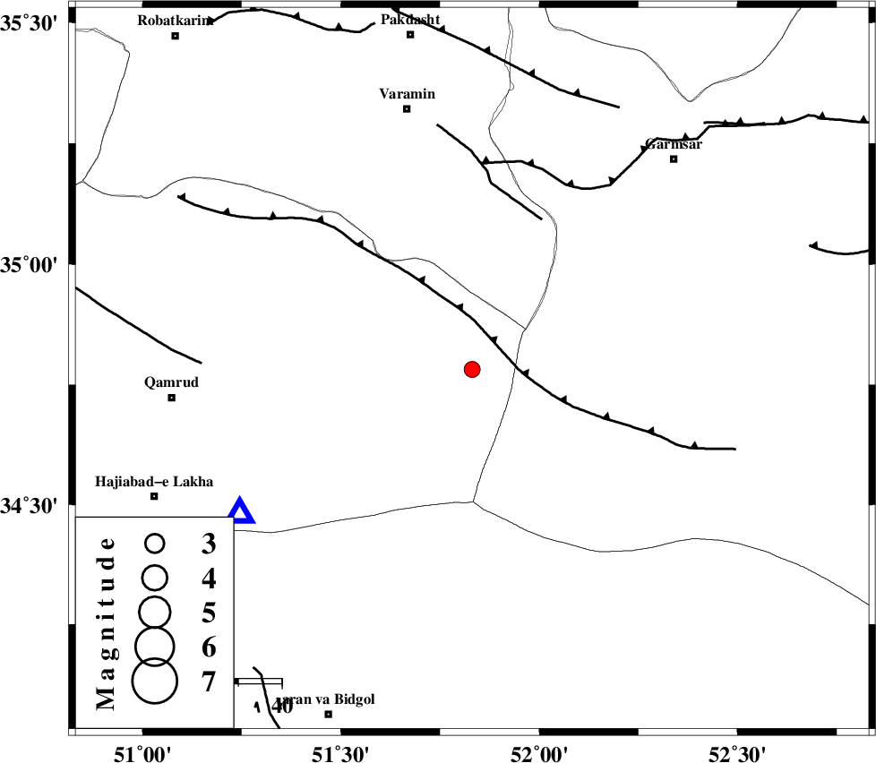
| Location | Lat:34.781 Lon: 51.831 |
| Region | Qom Province, 62 km South-East of Varamin |
Nearest Cities |
|
| 54 km North of Marnejab, Esfahan Province | |
| 56 km South of Shorqazi, Semnan Province | |
| 57 km South East of Ab barik, Tehran Province | |
| 59 km South West of Cheshmeh nadi, Semnan Province | |
| 59 km South of Pishva, Tehran Province | |
| Depth | 14 km |
| Agency | |
Faults within 150 km: |
|
| SIAHKUH_F (Length: 154 km) , Distance to epicenter: 8 km | |
| PISHAV_F (Length: 34 km) , Distance to epicenter: 38 km | |
| GARMSAR_F (Length: 77 km) , Distance to epicenter: 48 km | |
| Number of Phases | 7 |
| RMS | 0.2 |
| Number of Stations | 7 |
| Error in Latitude | >2.6 km |
| Error in Longitude | 3.6 km |
| Error in Depth | 5.5 km |
Download waveform in seisan format
to download seisan software Click here
to access information about IIEES stations Click here
Amplitude | ||||||||
| UID | Agency | Station | Component | Amplitude | Period | Arrival Time | Proccessing Time | Signal Clip |
| 107611 | IIEES | DAMV | E | 182.4 | 0.16 | 2016-07-14 07:01:52 | 2016-07-16 08:17:00 | n |
| 107612 | IIEES | DAMV | N | 178.8 | 0.14 | 2016-07-14 07:01:52 | 2016-07-16 08:17:00 | n |
| 107613 | IIEES | NASN | N | 21.7 | 0.21 | 2016-07-14 07:02:29 | 2016-07-16 08:17:00 | n |
| 107614 | IIEES | NASN | E | 23.9 | 0.42 | 2016-07-14 07:02:31 | 2016-07-16 08:17:00 | n |
Phase | ||||||||||||
| Agency | Station | Component | Phase Type | Phase Quality | First Motion | Observed Arrival Time | Time Residual | Loc. Flag | Input Weight | Distance | Azimuth | |
| IIEES | GHVR | Z | Pg | E | 2016-07-14 07:01:33 | -0.29 | y | 63.2 | 238 | |||
| IIEES | DAMV | Z | Pg | E | 2016-07-14 07:01:39 | 0.11 | y | 95 | 8 | |||
| IIEES | CHTH | Z | Pg | E | 2016-07-14 07:01:46 | -0.13 | y | 140 | 333 | |||
| IIEES | ASAO | Z | Pg | E | 2016-07-14 07:01:50 | 0.21 | y | 168 | 262 | |||
| IIEES | KHMZ | Z | Pn | E | 2016-07-14 07:01:56 | 0.15 | y | 207 | 237 | |||
| IIEES | NASN | Z | Pn | E | 2016-07-14 07:02:00 | 0.07 | y | 238 | 157 | |||
| IIEES | YZKH | Z | Pn | E | 2016-07-14 07:02:16 | -0.15 | y | 369 | 135 | |||