
Magnitude |
2.5 |
| Date & Time (UTC) | 2016-10-04 04:38:38.2 |
| Date & Time (Local) | 1395/7/13 08:08:38.2 |
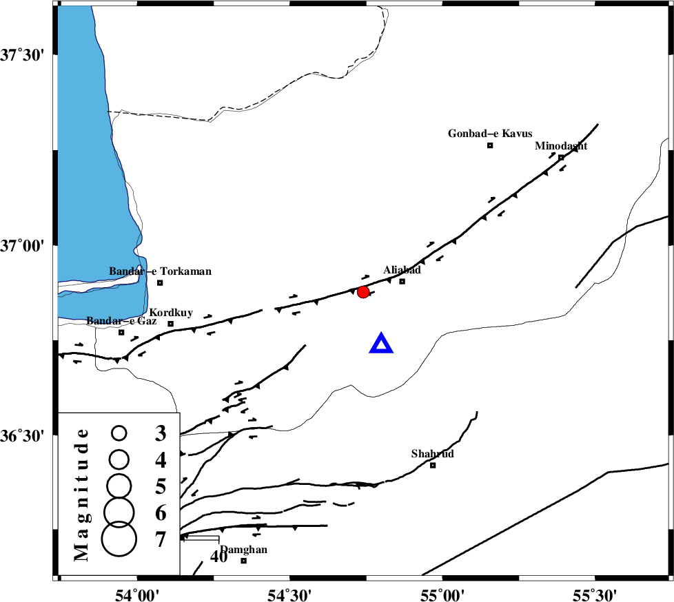
| Location | Lat:36.877 Lon: 54.74 |
| Region | Golestan Province, 12 km -West of Ali Abad |
Nearest Cities |
|
| 12 km West of Ali Abad, Golestan Province | |
| 17 km East of Nodeh malek, Golestan Province | |
| 18 km North East of Jalin olia, Golestan Province | |
| 23 km South of Gariduji, Golestan Province | |
| 26 km South East of Qanqarmeh, Golestan Province | |
| Depth | 18 km |
| Agency | |
Faults within 150 km: |
|
| KHAZAR_F (Length: 523 km) , Distance to epicenter: 21 km | |
| SHAVAR_F (Length: 87 km) , Distance to epicenter: 35 km | |
| N_ALBORZ_F (Length: 360 km) , Distance to epicenter: 43 km | |
| Number of Phases | 6 |
| RMS | 0.1 |
| Number of Stations | 5 |
| Error in Latitude | >2.1 km |
| Error in Longitude | 3.4 km |
| Error in Depth | 6.7 km |
Download waveform in seisan format
to download seisan software Click here
to access information about IIEES stations Click here
Amplitude | ||||||||
| UID | Agency | Station | Component | Amplitude | Period | Arrival Time | Proccessing Time | Signal Clip |
| 109663 | IIEES | MRVT | N | 53.2 | 0.17 | 2016-10-04 04:39:24 | 2016-10-04 06:13:00 | n |
| 109664 | IIEES | MRVT | E | 56 | 0.23 | 2016-10-04 04:39:25 | 2016-10-04 06:13:00 | n |
| 109665 | IIEES | DAMV | E | 26.4 | 0.39 | 2016-10-04 04:39:59 | 2016-10-04 06:13:00 | n |
| 109666 | IIEES | DAMV | N | 18.5 | 0.39 | 2016-10-04 04:40:00 | 2016-10-04 06:13:00 | n |
Phase | ||||||||||||
| Agency | Station | Component | Phase Type | Phase Quality | First Motion | Observed Arrival Time | Time Residual | Loc. Flag | Input Weight | Distance | Azimuth | |
| IIEES | MRVT | Z | Pg | E | 2016-10-04 04:39:02 | -0.17 | y | 148 | 54 | |||
| IIEES | MRVT | E | Sg | E | 2016-10-04 04:39:20 | 0.12 | y | 148 | 54 | |||
| IIEES | SHRO | Z | Pg | E | 2016-10-04 04:39:03 | 0.11 | y | 149 | 130 | |||
| IIEES | DAMV | Z | Pn | E | 2016-10-04 04:39:21 | 0.08 | y | 285 | 242 | |||
| IIEES | CHTH | Z | Pn | E | 2016-10-04 04:39:28 | 0 | y | 342 | 253 | |||
| IIEES | TABS | Z | Pn | E | 2016-10-04 04:39:37 | -0.16 | y | 418 | 148 | |||