
Magnitude |
3 |
| Date & Time (UTC) | 2017-01-27 04:05:57.7 |
| Date & Time (Local) | 1395/11/8 07:35:57.7 |
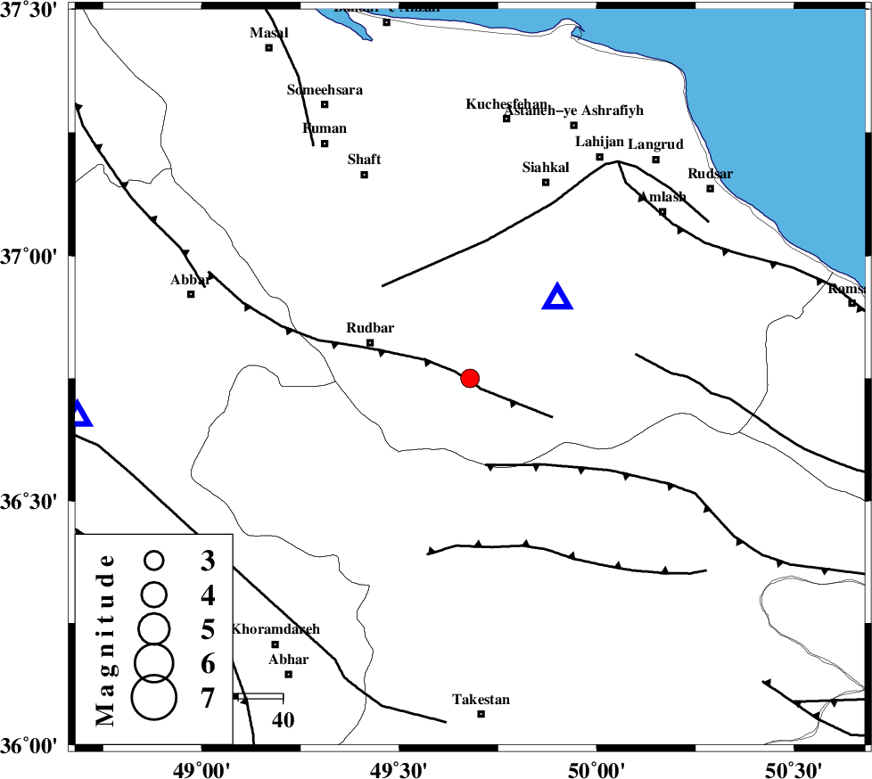
| Location | Lat:36.75 Lon: 49.679 |
| Region | Gilan Province, 24 km -East of Rudbar |
Nearest Cities |
|
| 11 km North West of Jirhandeh, Gilan Province | |
| 12 km South of Dashtvil, Gilan Province | |
| 21 km North East of Loshan, Gilan Province | |
| 22 km East of Rostamabad, Gilan Province | |
| 23 km South West of Barresar, Gilan Province | |
| Depth | 6 km |
| Agency | |
Faults within 150 km: |
|
| RUDBAR_F (Length: 93 km) , Distance to epicenter: 3 km | |
| ALAMUTRUD_F (Length: 140 km) , Distance to epicenter: 20 km | |
| LAHIJAN_F (Length: 92 km) , Distance to epicenter: 29 km | |
| Number of Phases | 9 |
| RMS | 0.3 |
| Number of Stations | 8 |
| Error in Latitude | >3 km |
| Error in Longitude | 3.4 km |
| Error in Depth | 5.1 km |
Download waveform in seisan format
to download seisan software Click here
to access information about IIEES stations Click here
Amplitude | ||||||||
| UID | Agency | Station | Component | Amplitude | Period | Arrival Time | Proccessing Time | Signal Clip |
| 112663 | IIEES | GIDE | E | 3456.1 | 0.17 | 2017-01-27 04:06:07 | 2017-01-28 06:35:00 | n |
| 112664 | IIEES | GIDE | N | 5526.4 | 0.1 | 2017-01-27 04:06:07 | 2017-01-28 06:35:00 | n |
| 112665 | IIEES | GHVR | N | 37.6 | 0.78 | 2017-01-27 04:07:22 | 2017-01-28 06:35:00 | n |
| 112666 | IIEES | GHVR | E | 32.2 | 0.33 | 2017-01-27 04:07:26 | 2017-01-28 06:35:00 | n |
Phase | ||||||||||||
| Agency | Station | Component | Phase Type | Phase Quality | First Motion | Observed Arrival Time | Time Residual | Loc. Flag | Input Weight | Distance | Azimuth | |
| IIEES | GIDE | Z | Pg | E | 2017-01-27 04:06:03 | 0.3 | y | 28.1 | 47 | |||
| IIEES | ZNJK | Z | Pg | E | 2017-01-27 04:06:13 | 0.1 | y | 89.3 | 265 | |||
| IIEES | CHTH | Z | Pg | E | 2017-01-27 04:06:25 | -0.42 | y | 160 | 125 | |||
| IIEES | ASAO | Z | Pn | E | 2017-01-27 04:06:37 | 0.04 | y | 246 | 173 | |||
| IIEES | GRMI | Z | Pn | E | 2017-01-27 04:06:40 | -0.38 | y | 277 | 326 | |||
| IIEES | SNGE | Z | Pn | E | 2017-01-27 04:06:44 | 3.03 | n | 4 | 280 | 230 | ||
| IIEES | GHVR | Z | Pn | E | 2017-01-27 04:06:45 | 2.72 | n | 4 | 289 | 150 | ||
| IIEES | KHMZ | Z | Pn | E | 2017-01-27 04:06:48 | 0.3 | y | 335 | 175 | |||
| IIEES | MRVT | Z | Pn | E | 2017-01-27 04:07:18 | 0.12 | y | 578 | 78 | |||