
Magnitude |
2.8 |
| Date & Time (UTC) | 2017-02-21 04:27:21.0 |
| Date & Time (Local) | 1395/12/3 07:57:21.0 |
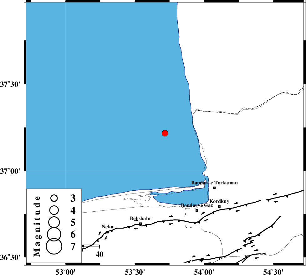
| Location | Lat:37.216 Lon: 53.717 |
| Region | Caspian Sea, 47 km North-West of Bandar-e torkaman |
Nearest Cities |
|
| 35 km North West of Gomishtappeh, Golestan Province | |
| 47 km North West of Bandar-e torkaman, Golestan Province | |
| 51 km North West of Banavar, Golestan Province | |
| 51 km North West of Sijval, Golestan Province | |
| 54 km North West of Bandar-e gaz, Golestan Province | |
| Depth | 15 km |
| Agency | |
Faults within 150 km: |
|
| KHAZAR_F (Length: 523 km) , Distance to epicenter: 55 km | |
| N_ALBORZ_F (Length: 360 km) , Distance to epicenter: 82 km | |
| SHAVAR_F (Length: 87 km) , Distance to epicenter: 95 km | |
| Number of Phases | 4 |
| RMS | 0.1 |
| Number of Stations | 4 |
| Error in Latitude | >4.9 km |
| Error in Longitude | 1.1 km |
| Error in Depth | 0 km |
Download waveform in seisan format
to download seisan software Click here
to access information about IIEES stations Click here
Amplitude | ||||||||
| UID | Agency | Station | Component | Amplitude | Period | Arrival Time | Proccessing Time | Signal Clip |
| 113495 | IIEES | DAMV | E | 55 | 0.34 | 2017-02-21 04:28:28 | 2017-02-21 06:19:00 | n |
| 113496 | IIEES | DAMV | N | 47.6 | 0.54 | 2017-02-21 04:28:29 | 2017-02-21 06:19:00 | n |
Phase | ||||||||||||
| Agency | Station | Component | Phase Type | Phase Quality | First Motion | Observed Arrival Time | Time Residual | Loc. Flag | Input Weight | Distance | Azimuth | |
| IIEES | MRVT | Z | Pn | E | 2017-02-21 04:27:55 | -0.04 | y | 216 | 76 | |||
| IIEES | DAMV | Z | Pn | E | 2017-02-21 04:27:57 | -0.15 | y | 236 | 222 | |||
| IIEES | SHRO | Z | Pn | E | 2017-02-21 04:27:59 | 0.06 | y | 245 | 122 | |||
| IIEES | CHTH | Z | Pn | E | 2017-02-21 04:28:02 | 0.13 | y | 274 | 239 | |||