
Magnitude |
2.6 |
| Date & Time (UTC) | 2017-11-14 16:47:36.4 |
| Date & Time (Local) | 1396/8/23 20:17:36.4 |
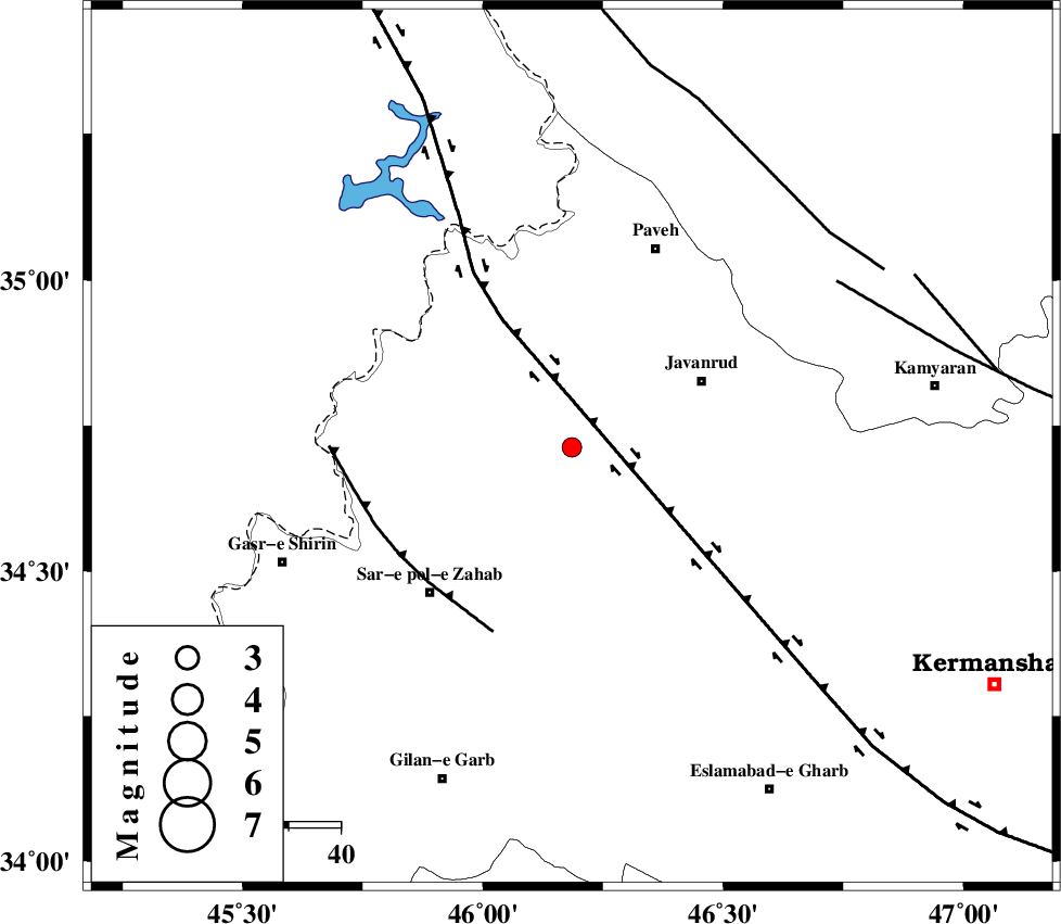
| Location | Lat:34.713 Lon: 46.185 |
| Region | Kermanshah Province, 28 km South-West of Javanrud |
Nearest Cities |
|
| 2 km of Qolqoleh, Kermanshah Province | |
| 12 km North West of Mirabad, Kermanshah Province | |
| 17 km South of Shervineh, Kermanshah Province | |
| 25 km South of Mazran, Kermanshah Province | |
| 25 km South East of Dehsheykh, Kermanshah Province | |
| Depth | 17 km |
| Agency | |
Faults within 150 km: |
|
| HZF4 (Length: 492 km) , Distance to epicenter: 6 km | |
| MFF8 (Length: 48 km) , Distance to epicenter: 38 km | |
| SARTAKHT_F (Length: 78 km) , Distance to epicenter: 59 km | |
| Number of Phases | 5 |
| RMS | 0.1 |
| Number of Stations | 3 |
| Error in Latitude | >3.1 km |
| Error in Longitude | 5.5 km |
| Error in Depth | 4.1 km |
Download waveform in seisan format
to download seisan software Click here
to access information about IIEES stations Click here
Amplitude | ||||||||
| UID | Agency | Station | Component | Amplitude | Period | Arrival Time | Proccessing Time | Signal Clip |
| 122218 | IIEES | SNGE | N | 159.9 | 0.32 | 2017-11-14 16:48:12 | 2017-11-20 12:13:00 | n |
| 122219 | IIEES | SNGE | E | 173.5 | 0.32 | 2017-11-14 16:48:13 | 2017-11-20 12:13:00 | n |
| 122220 | IIEES | ASAO | N | 9.3 | 0.08 | 2017-11-14 16:49:28 | 2017-11-20 12:13:00 | n |
Phase | ||||||||||||
| Agency | Station | Component | Phase Type | Phase Quality | First Motion | Observed Arrival Time | Time Residual | Loc. Flag | Input Weight | Distance | Azimuth | |
| IIEES | SNGE | Z | Pg | E | 2017-11-14 16:47:55 | -0.09 | y | 114 | 68 | |||
| IIEES | SNGE | N | Sg | E | 2017-11-14 16:48:09 | 0.05 | y | 114 | 68 | |||
| IIEES | ILBA | Z | Pg | E | 2017-11-14 16:47:56 | 0.09 | y | 121 | 179 | |||
| IIEES | ILBA | N | Sg | E | 2017-11-14 16:48:11 | -0.05 | y | 121 | 179 | |||
| IIEES | ASAO | Z | Pn | E | 2017-11-14 16:48:27 | 0 | y | 353 | 92 | |||