
Magnitude |
2.5 |
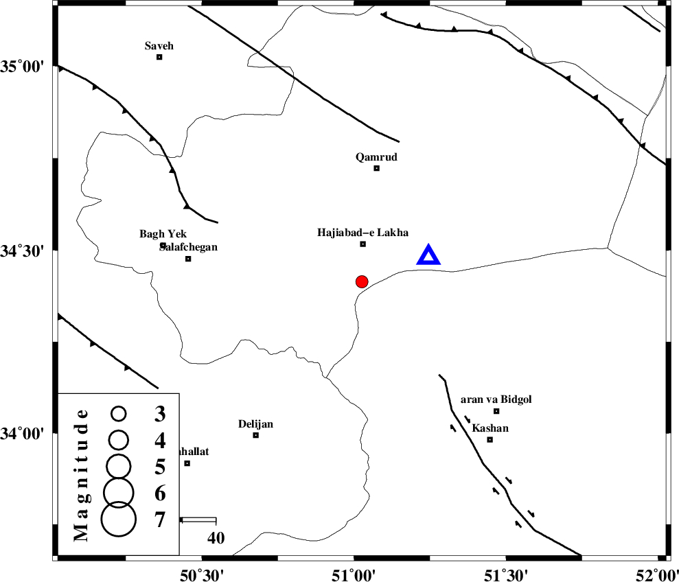
| Date & Time (UTC) | 2017-11-23 14:08:14.2 |
| Date & Time (Local) | 1396/9/2 17:38:14.2 |
| Location | Lat:34.414 Lon: 51.026 |
| Region | Qom Province, 30 km South-East of Qom |
Nearest Cities |
|
| 11 km South of Hajiabad-e lakha, Qom Province | |
| 15 km North East of Kahak, Qom Province | |
| 20 km North of Yahyaabad, Esfahan Province | |
| 30 km South East of Qom, Qom Province | |
| 33 km North of Armak, Esfahan Province | |
| Depth | 16 km |
| Agency | |
Faults within 150 km: |
|
| KASHAN_F (Length: 44 km) , Distance to epicenter: 37 km | |
| KUSHK_E_NOSRAT_F (Length: 230 km) , Distance to epicenter: 44 km | |
| INDES_F (Length: 98 km) , Distance to epicenter: 47 km | |
| Number of Phases | 8 |
| RMS | 0.5 |
| Number of Stations | 8 |
| Error in Latitude | >4.5 km |
| Error in Longitude | 5.3 km |
| Error in Depth | 7.9 km |
Download waveform in seisan format
to download seisan software Click here
to access information about IIEES stations Click here
Amplitude | ||||||||
| UID | Agency | Station | Component | Amplitude | Period | Arrival Time | Proccessing Time | Signal Clip |
| 122469 | IIEES | GHVR | N | 1230.9 | 0.16 | 2017-11-23 14:08:24 | 2017-11-25 09:11:00 | n |
| 122470 | IIEES | GHVR | E | 802.9 | 0.33 | 2017-11-23 14:08:25 | 2017-11-25 09:11:00 | n |
| 122471 | IIEES | DAMV | E | 127.6 | 0.33 | 2017-11-23 14:09:02 | 2017-11-25 09:11:00 | n |
| 122472 | IIEES | DAMV | N | 78.2 | 0.4 | 2017-11-23 14:09:02 | 2017-11-25 09:11:00 | n |
| 122473 | IIEES | THKV | N | 35.5 | 0.22 | 2017-11-23 14:09:06 | 2017-11-25 09:11:00 | n |
Phase | ||||||||||||
| Agency | Station | Component | Phase Type | Phase Quality | First Motion | Observed Arrival Time | Time Residual | Loc. Flag | Input Weight | Distance | Azimuth | |
| IIEES | GHVR | Z | Pg | E | 2017-11-23 14:08:19 | 0.68 | y | 21.4 | 70 | |||
| IIEES | ASAO | Z | Pg | E | 2017-11-23 14:08:30 | 0.06 | y | 93.1 | 279 | |||
| IIEES | KHMZ | Z | Pg | E | 2017-11-23 14:08:34 | -0.24 | y | 123 | 233 | |||
| IIEES | DAMV | Z | Pg | E | 2017-11-23 14:08:40 | -0.32 | y | 160 | 32 | |||
| IIEES | CHTH | Z | Pg | E | 2017-11-23 14:08:41 | -0.56 | y | 166 | 3 | |||
| IIEES | THKV | Z | Pg | E | 2017-11-23 14:08:41 | -0.12 | y | 167 | 355 | |||
| IIEES | NASN | Z | Pn | E | 2017-11-23 14:08:52 | -0.24 | y | 244 | 137 | |||
| IIEES | ZNJK | Z | Pn | E | 2017-11-23 14:09:03 | 0.84 | y | 328 | 320 | |||