
Magnitude |
2.6 |
| Date & Time (UTC) | 2018-01-03 20:23:25.4 |
| Date & Time (Local) | 1396/10/13 23:53:25.4 |
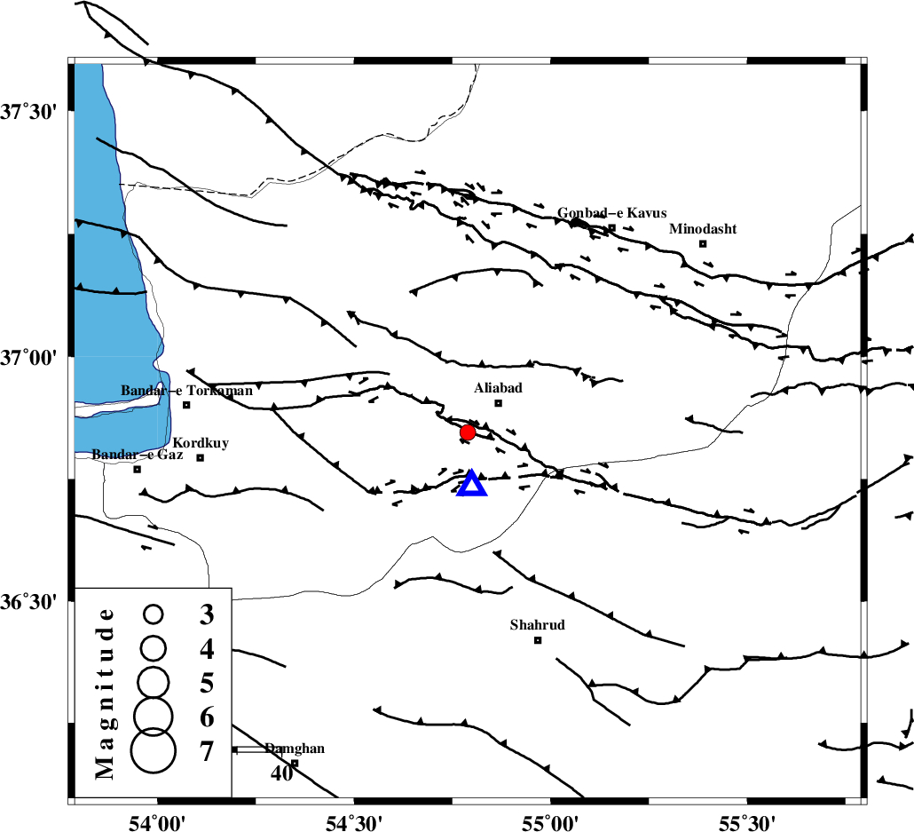
| Location | Lat:36.845 Lon: 54.789 |
| Region | Golestan Province, 10 km of Ali Abad |
Nearest Cities |
|
| 10 km of Ali Abad, Golestan Province | |
| 22 km East of Jalin olia, Golestan Province | |
| 23 km South East of Nodeh malek, Golestan Province | |
| 26 km South West of Khanbebin, Golestan Province | |
| 27 km South of Gariduji, Golestan Province | |
| Depth | 18 km |
| Agency | |
Faults within 150 km: |
|
| KHAZAR_F (Length: 523 km) , Distance to epicenter: 24 km | |
| SHAVAR_F (Length: 87 km) , Distance to epicenter: 30 km | |
| ASTANEH_F (Length: 72 km) , Distance to epicenter: 44 km | |
| Number of Phases | 6 |
| RMS | 0.1 |
| Number of Stations | 5 |
| Error in Latitude | >2.7 km |
| Error in Longitude | 2.9 km |
| Error in Depth | 5 km |
Download waveform in seisan format
to download seisan software Click here
to access information about IIEES stations Click here
Amplitude | ||||||||
| UID | Agency | Station | Component | Amplitude | Period | Arrival Time | Proccessing Time | Signal Clip |
| 126476 | IIEES | MRVT | E | 119.7 | 0.15 | 2018-01-03 20:24:12 | 2018-01-08 11:08:00 | n |
| 126477 | IIEES | MRVT | N | 96.8 | 0.28 | 2018-01-03 20:24:13 | 2018-01-08 11:08:00 | n |
| 126478 | IIEES | BJRD | N | 20 | 0.45 | 2018-01-03 20:24:40 | 2018-01-08 11:08:00 | n |
| 126479 | IIEES | BJRD | E | 25.9 | 0.74 | 2018-01-03 20:24:49 | 2018-01-08 11:08:00 | n |
| 126480 | IIEES | DAMV | N | 24.4 | 0.4 | 2018-01-03 20:24:45 | 2018-01-08 11:08:00 | n |
| 126481 | IIEES | DAMV | E | 25.4 | 0.3 | 2018-01-03 20:24:46 | 2018-01-08 11:08:00 | n |
Phase | ||||||||||||
| Agency | Station | Component | Phase Type | Phase Quality | First Motion | Observed Arrival Time | Time Residual | Loc. Flag | Input Weight | Distance | Azimuth | |
| IIEES | SHRO | Z | Pg | E | 2018-01-03 20:23:49 | -0.04 | y | 144 | 130 | |||
| IIEES | MRVT | Z | Pg | E | 2018-01-03 20:23:49 | -0.06 | y | 147 | 52 | |||
| IIEES | BJRD | Z | Pn | E | 2018-01-03 20:24:03 | -0.07 | y | 251 | 67 | |||
| IIEES | BJRD | N | Sg | E | 2018-01-03 20:24:36 | 0.1 | y | 251 | 67 | |||
| IIEES | DAMV | Z | Pn | E | 2018-01-03 20:24:08 | 0.2 | y | 287 | 243 | |||
| IIEES | CHTH | Z | Pn | E | 2018-01-03 20:24:15 | -0.14 | y | 345 | 254 | |||