
Magnitude |
2.5 |
| Date & Time (UTC) | 2018-03-16 16:01:25.8 |
| Date & Time (Local) | 1396/12/25 19:31:25.8 |
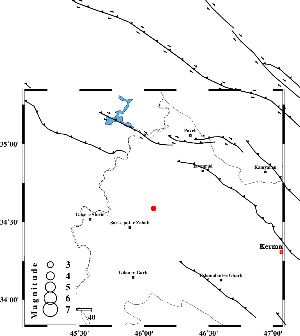
| Location | Lat:34.586 Lon: 46.073 |
| Region | Kermanshah Province, 22 km North-East of Sar-e pol-e zahab |
Nearest Cities |
|
| 15 km East of Bazmirabad, Kermanshah Province | |
| 16 km North of Rijab, Kermanshah Province | |
| 17 km South of Qolqoleh, Kermanshah Province | |
| 22 km North East of Sar-e pol-e zahab, Kermanshah Province | |
| 24 km West of Mirabad, Kermanshah Province | |
| Depth | 14 km |
| Agency | |
Faults within 150 km: |
|
| MFF8 (Length: 48 km) , Distance to epicenter: 21 km | |
| HZF4 (Length: 492 km) , Distance to epicenter: 23 km | |
| SARTAKHT_F (Length: 78 km) , Distance to epicenter: 76 km | |
| Number of Phases | 6 |
| RMS | 0.2 |
| Number of Stations | 4 |
| Error in Latitude | >1.6 km |
| Error in Longitude | 5.1 km |
| Error in Depth | 9.1 km |
Download waveform in seisan format
to download seisan software Click here
to access information about IIEES stations Click here
Amplitude | ||||||||
| UID | Agency | Station | Component | Amplitude | Period | Arrival Time | Proccessing Time | Signal Clip |
| 129585 | IIEES | ILBA | N | 89.9 | 0.2 | 2018-03-16 16:02:04 | 2018-03-17 08:57:00 | n |
| 129586 | IIEES | ILBA | E | 113.3 | 0.4 | 2018-03-16 16:02:05 | 2018-03-17 08:57:00 | n |
| 129587 | IIEES | SRSL | N | 55.8 | 0.5 | 2018-03-16 16:02:25 | 2018-03-17 08:57:00 | n |
| 129588 | IIEES | SRSL | E | 43 | 0.46 | 2018-03-16 16:02:27 | 2018-03-17 08:57:00 | n |
Phase | ||||||||||||
| Agency | Station | Component | Phase Type | Phase Quality | First Motion | Observed Arrival Time | Time Residual | Loc. Flag | Input Weight | Distance | Azimuth | |
| IIEES | ILBA | Z | Pg | E | 2018-03-16 16:01:43 | -0.44 | y | 107 | 173 | |||
| IIEES | ILBA | N | Sg | E | 2018-03-16 16:01:57 | 0.33 | y | 107 | 173 | |||
| IIEES | SNGE | Z | Pg | E | 2018-03-16 16:01:47 | -0.04 | y | 129 | 64 | |||
| IIEES | SRSL | Z | Pg | E | 2018-03-16 16:01:57 | -0.06 | y | 190 | 342 | |||
| IIEES | SRSL | N | Sg | E | 2018-03-16 16:02:20 | 0.13 | y | 190 | 342 | |||
| IIEES | ASAO | Z | Pn | E | 2018-03-16 16:02:18 | 0.11 | y | 363 | 90 | |||