
Magnitude |
2.2 |
| Date & Time (UTC) | 2018-04-01 14:10:54.6 |
| Date & Time (Local) | 1397/1/12 18:40:54.6 |
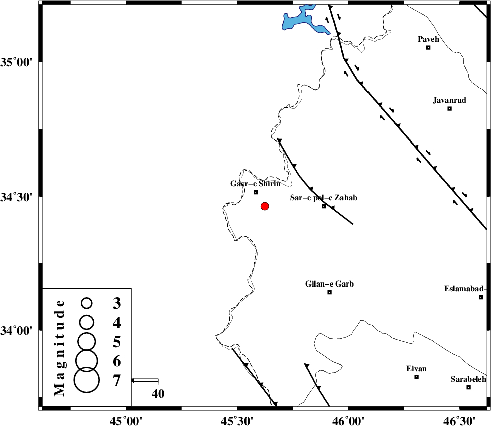
| Location | Lat:34.463 Lon: 45.623 |
| Region | Kermanshah Province, 7 km of Qasr-E-Shirin |
Nearest Cities |
|
| 3 km North of Seyyed sohrab, Kermanshah Province | |
| 7 km of Qasr-E-Shirin, Kermanshah Province | |
| 10 km of Aqabarar, Kermanshah Province | |
| 14 km West of Qareh belagh, Kermanshah Province | |
| 15 km North East of Khosravi, Kermanshah Province | |
| Depth | 14 km |
| Agency | |
Faults within 150 km: |
|
| MFF8 (Length: 48 km) , Distance to epicenter: 19 km | |
| ZFF4 (Length: 128 km) , Distance to epicenter: 60 km | |
| HZF4 (Length: 492 km) , Distance to epicenter: 64 km | |
| Number of Phases | 4 |
| RMS | 0 |
| Number of Stations | 3 |
| Error in Latitude | >1.6 km |
| Error in Longitude | 8.5 km |
| Error in Depth | 4.7 km |
Download waveform in seisan format
to download seisan software Click here
to access information about IIEES stations Click here
Amplitude | ||||||||
| UID | Agency | Station | Component | Amplitude | Period | Arrival Time | Proccessing Time | Signal Clip |
| 133108 | IIEES | ILBA | E | 73 | 0.4 | 2018-04-01 14:11:34 | 2018-06-03 11:40:00 | n |
| 133109 | IIEES | ILBA | N | 67.4 | 0.44 | 2018-04-01 14:11:35 | 2018-06-03 11:40:00 | n |
Phase | ||||||||||||
| Agency | Station | Component | Phase Type | Phase Quality | First Motion | Observed Arrival Time | Time Residual | Loc. Flag | Input Weight | Distance | Azimuth | |
| IIEES | ILBA | Z | Pg | E | 2018-04-01 14:11:12 | -0.01 | y | 108 | 150 | |||
| IIEES | ILBA | N | Sg | E | 2018-04-01 14:11:26 | 0 | y | 108 | 150 | |||
| IIEES | SNGE | Z | Pg | E | 2018-04-01 14:11:23 | -0.03 | y | 173 | 66 | |||
| IIEES | ASAO | Z | Pn | E | 2018-04-01 14:11:52 | 0.05 | y | 404 | 87 | |||