
Magnitude |
2.9 |
| Date & Time (UTC) | 2018-07-17 14:58:12.7 |
| Date & Time (Local) | 1397/4/26 19:28:12.7 |
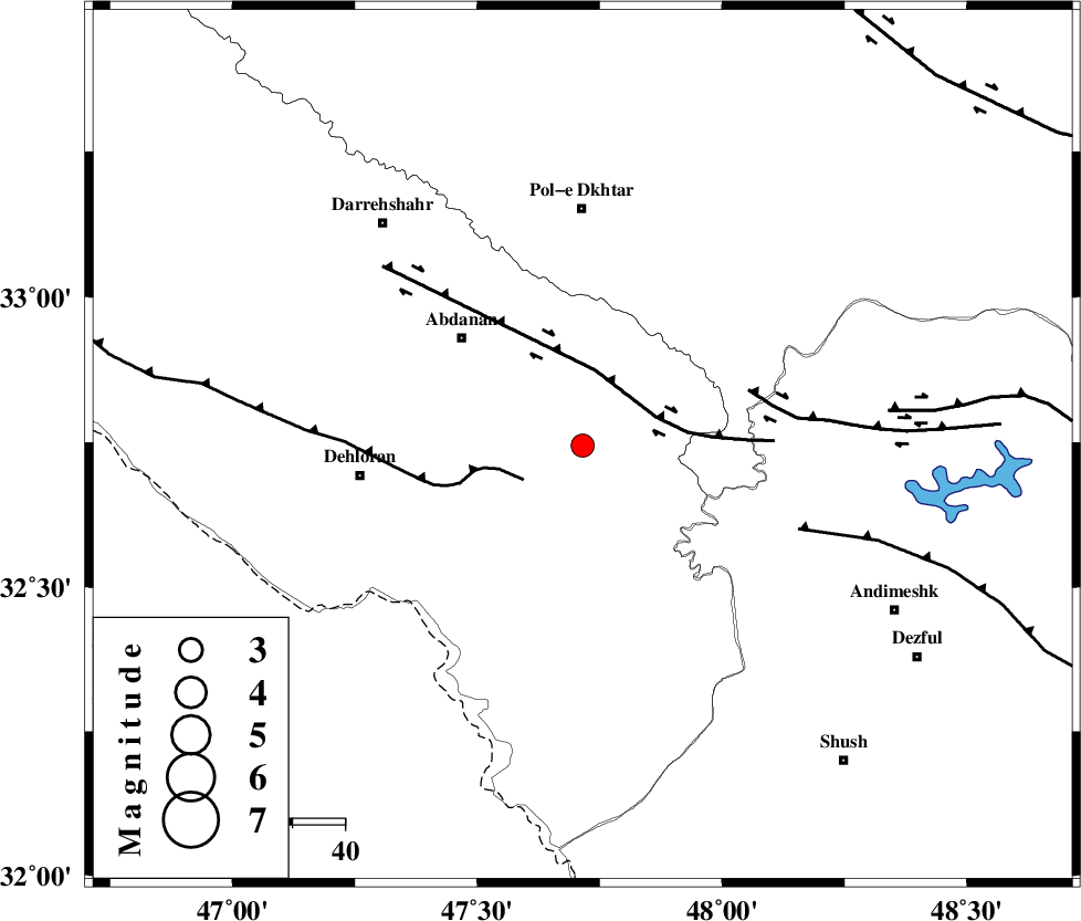
| Location | Lat:32.744 Lon: 47.715 |
| Region | Ilam Province, 45 km South of Pol-e dokhtar |
Nearest Cities |
|
| 22 km South East of Sarabbagh, Ilam Province | |
| 31 km South East of Abdanan, Ilam Province | |
| 39 km South of Sarab hammam, Lorestan Province | |
| 40 km North East of Musian, Ilam Province | |
| 43 km North East of Dehloran, Ilam Province | |
| Depth | 14 km |
| Agency | |
Faults within 150 km: |
|
| MFF6 (Length: 144 km) , Distance to epicenter: 13 km | |
| BALARUD_F_Z1 (Length: 87 km) , Distance to epicenter: 15 km | |
| BALARUD_F_Z3 (Length: 53 km) , Distance to epicenter: 33 km | |
| Number of Phases | 7 |
| RMS | 0.1 |
| Number of Stations | 6 |
| Error in Latitude | >8.7 km |
| Error in Longitude | 1.6 km |
| Error in Depth | 4.5 km |
Download waveform in seisan format
to download seisan software Click here
to access information about IIEES stations Click here
Amplitude | ||||||||
| UID | Agency | Station | Component | Amplitude | Period | Arrival Time | Proccessing Time | Signal Clip |
| 134757 | IIEES | ILBA | E | 216 | 0.65 | 2018-07-17 14:59:07 | 2018-07-18 06:48:00 | n |
| 134758 | IIEES | ILBA | N | 235.6 | 0.45 | 2018-07-17 14:59:14 | 2018-07-18 06:48:00 | n |
| 134759 | IIEES | SNGE | E | 21.6 | 0.41 | 2018-07-17 14:59:19 | 2018-07-18 06:48:00 | n |
| 134760 | IIEES | GHVR | N | 17.2 | 0.45 | 2018-07-17 15:00:01 | 2018-07-18 06:48:00 | n |
| 134761 | IIEES | GHVR | E | 18.4 | 0.58 | 2018-07-17 15:00:07 | 2018-07-18 06:48:00 | n |
Phase | ||||||||||||
| Agency | Station | Component | Phase Type | Phase Quality | First Motion | Observed Arrival Time | Time Residual | Loc. Flag | Input Weight | Distance | Azimuth | |
| IIEES | ILBA | Z | Pg | E | 2018-07-17 14:58:40 | -0.08 | y | 171 | 305 | |||
| IIEES | KHMZ | Z | Pn | E | 2018-07-17 14:58:50 | 0.07 | y | 237 | 62 | |||
| IIEES | KHMZ | N | Sg | E | 2018-07-17 14:59:19 | -0.05 | y | 237 | 62 | |||
| IIEES | SNGE | Z | Pn | E | 2018-07-17 14:58:40 | -13.1 | n | 4 | 263 | 353 | ||
| IIEES | ASAO | Z | Pn | E | 2018-07-17 14:58:57 | 0.15 | y | 293 | 46 | |||
| IIEES | GHVR | Z | Pn | E | 2018-07-17 14:59:07 | -0.17 | y | 380 | 59 | |||
| IIEES | SRSL | Z | Pn | E | 2018-07-17 14:59:15 | 0.08 | y | 438 | 332 | |||