
Magnitude |
2.9 |
| Date & Time (UTC) | 2018-08-13 10:07:44.9 |
| Date & Time (Local) | 1397/5/22 14:37:44.9 |
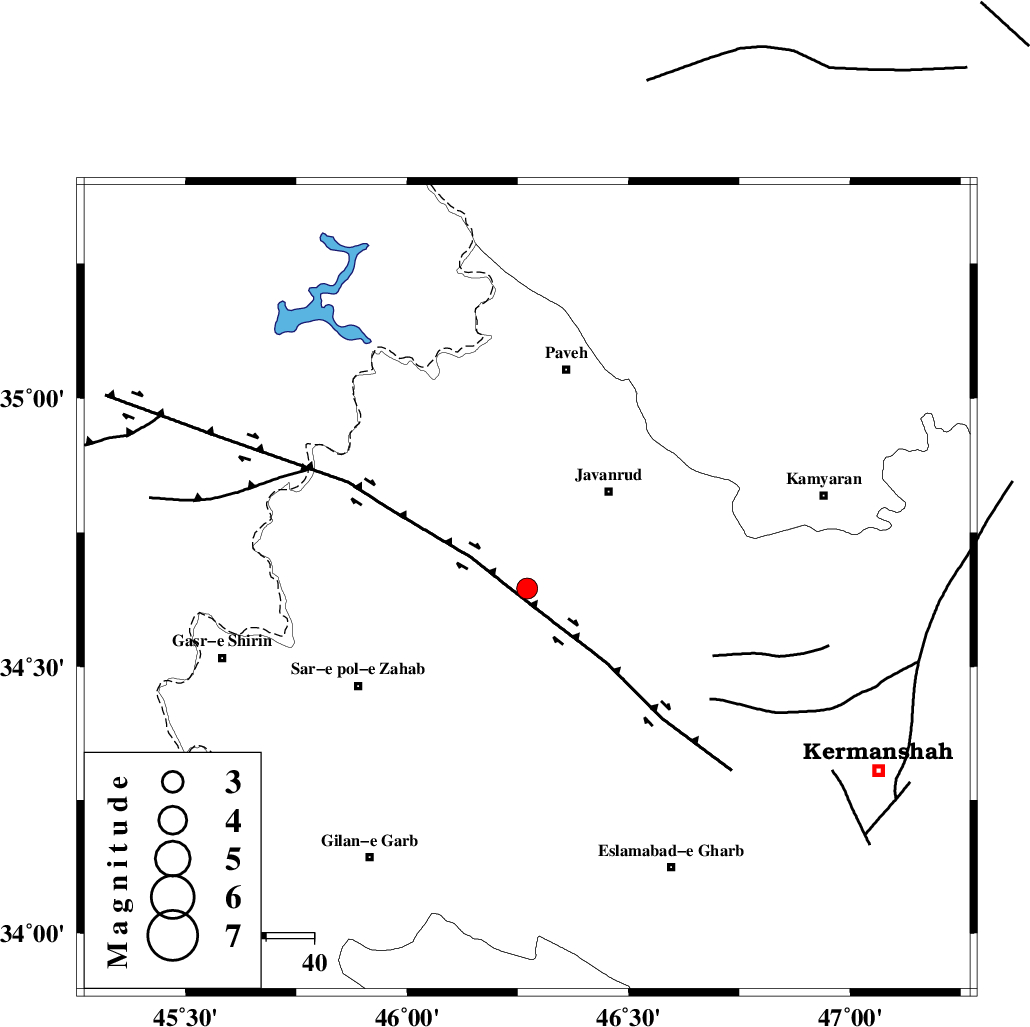
| Location | Lat:34.646 Lon: 46.271 |
| Region | Kermanshah Province, 26 km South-West of Javanrud |
Nearest Cities |
|
| 6 km of Mirabad, Kermanshah Province | |
| 13 km East of Qolqoleh, Kermanshah Province | |
| 17 km North of Zavleh olia, Kermanshah Province | |
| 19 km West of Dolatabad, Kermanshah Province | |
| 21 km South West of Sarukhan, Kermanshah Province | |
| Depth | 16 km |
| Agency | |
Faults within 150 km: |
|
| HZF4 (Length: 492 km) , Distance to epicenter: 12 km | |
| MFF8 (Length: 48 km) , Distance to epicenter: 36 km | |
| SARTAKHT_F (Length: 78 km) , Distance to epicenter: 58 km | |
| Number of Phases | 6 |
| RMS | 0.2 |
| Number of Stations | 5 |
| Error in Latitude | >2.2 km |
| Error in Longitude | 2.6 km |
| Error in Depth | 4.8 km |
Download waveform in seisan format
to download seisan software Click here
to access information about IIEES stations Click here
Amplitude | ||||||||
| UID | Agency | Station | Component | Amplitude | Period | Arrival Time | Proccessing Time | Signal Clip |
| 135640 | IIEES | SNGE | E | 226.7 | 0.39 | 2018-08-13 10:08:21 | 2018-08-14 06:02:00 | n |
| 135641 | IIEES | SNGE | N | 295.1 | 0.56 | 2018-08-13 10:08:21 | 2018-08-14 06:02:00 | n |
| 135642 | IIEES | ILBA | N | 248.9 | 0.37 | 2018-08-13 10:08:25 | 2018-08-14 06:02:00 | n |
| 135643 | IIEES | ILBA | E | 331.1 | 0.42 | 2018-08-13 10:08:26 | 2018-08-14 06:02:00 | n |
| 135644 | IIEES | SRSL | E | 151.3 | 0.61 | 2018-08-13 10:08:45 | 2018-08-14 06:02:00 | n |
| 135645 | IIEES | SRSL | N | 164.3 | 0.31 | 2018-08-13 10:08:47 | 2018-08-14 06:02:00 | n |
| 135646 | IIEES | ASAO | N | 22.6 | 0.85 | 2018-08-13 10:09:38 | 2018-08-14 06:02:00 | n |
Phase | ||||||||||||
| Agency | Station | Component | Phase Type | Phase Quality | First Motion | Observed Arrival Time | Time Residual | Loc. Flag | Input Weight | Distance | Azimuth | |
| IIEES | SNGE | Z | Pg | E | 2018-08-13 10:08:03 | -0.06 | y | 110 | 63 | |||
| IIEES | SNGE | N | Sg | E | 2018-08-13 10:08:17 | 0.03 | y | 110 | 63 | |||
| IIEES | ILBA | Z | Pg | E | 2018-08-13 10:08:04 | 0.04 | y | 113 | 183 | |||
| IIEES | SRSL | Z | Pg | E | 2018-08-13 10:08:16 | -0.01 | y | 190 | 337 | |||
| IIEES | ASAO | Z | Pn | E | 2018-08-13 10:08:35 | 0.3 | y | 345 | 91 | |||
| IIEES | KHMZ | Z | Pn | E | 2018-08-13 10:08:36 | -0.3 | y | 355 | 105 | |||