
Magnitude |
2.9 |
| Date & Time (UTC) | 2018-08-15 17:01:31.8 |
| Date & Time (Local) | 1397/5/24 21:31:31.8 |
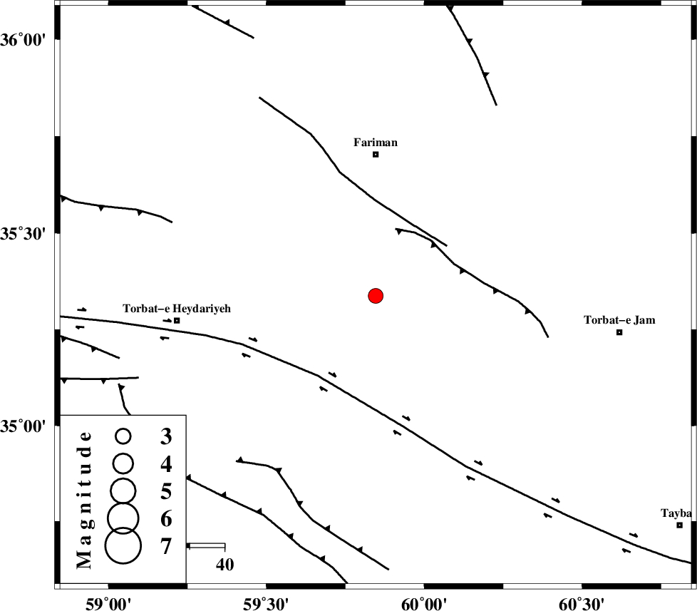
| Location | Lat:35.337 Lon: 59.846 |
| Region | Khorasan(center) Province, 41 km South of Fariman |
Nearest Cities |
|
| 8 km North of Choqmaq, Khorasan(center) Province | |
| 27 km West of Karizun, Khorasan(center) Province | |
| 30 km South West of Galandarabad, Khorasan(center) Province | |
| 31 km South East of Zarlag, Khorasan(center) Province | |
| 39 km North West of Ghalehno-e olia, Khorasan(center) Province | |
| Depth | 14 km |
| Agency | |
Faults within 150 km: |
|
| TORBAT_E_JAM_F2 (Length: 57 km) , Distance to epicenter: 20 km | |
| TORBAT_E_JAM_F1 (Length: 71 km) , Distance to epicenter: 23 km | |
| DORUNEH_F (Length: 713 km) , Distance to epicenter: 28 km | |
| Number of Phases | 8 |
| RMS | 0.3 |
| Number of Stations | 6 |
| Error in Latitude | >4.2 km |
| Error in Longitude | 4.5 km |
| Error in Depth | 9.8 km |
Download waveform in seisan format
to download seisan software Click here
to access information about IIEES stations Click here
Amplitude | ||||||||
| UID | Agency | Station | Component | Amplitude | Period | Arrival Time | Proccessing Time | Signal Clip |
| 135906 | IIEES | SHRT | N | 156.9 | 0.29 | 2018-08-15 17:02:29 | 2018-08-20 07:24:00 | n |
| 135907 | IIEES | SHRT | E | 103.4 | 0.31 | 2018-08-15 17:02:29 | 2018-08-20 07:24:00 | n |
| 135908 | IIEES | TABS | N | 28.4 | 0.7 | 2018-08-15 17:03:11 | 2018-08-20 07:24:00 | n |
Phase | ||||||||||||
| Agency | Station | Component | Phase Type | Phase Quality | First Motion | Observed Arrival Time | Time Residual | Loc. Flag | Input Weight | Distance | Azimuth | |
| IIEES | SHRT | Z | Pg | E | 2018-08-15 17:02:03 | -0.35 | y | 192 | 168 | |||
| IIEES | SHRT | N | Sg | E | 2018-08-15 17:02:26 | 0.11 | y | 192 | 168 | |||
| IIEES | TABS | Z | Pn | E | 2018-08-15 17:02:18 | 0.37 | y | 313 | 234 | |||
| IIEES | TABS | N | Sg | E | 2018-08-15 17:02:59 | -0.18 | y | 313 | 234 | |||
| IIEES | BJRD | Z | Pn | E | 2018-08-15 17:02:22 | 0.21 | y | 341 | 321 | |||
| IIEES | SHRO | Z | Pn | E | 2018-08-15 17:02:23 | 0.21 | y | 355 | 283 | |||
| IIEES | BSRN | Z | Pn | E | 2018-08-15 17:02:26 | 0.16 | y | 380 | 190 | |||
| IIEES | MRVT | Z | Pn | E | 2018-08-15 17:02:31 | -0.57 | y | 424 | 309 | |||

 IIEES All Rights Reserved