
Magnitude |
2.5 |
| Date & Time (UTC) | 2018-09-04 04:39:32.3 |
| Date & Time (Local) | 1397/6/13 09:09:32.3 |
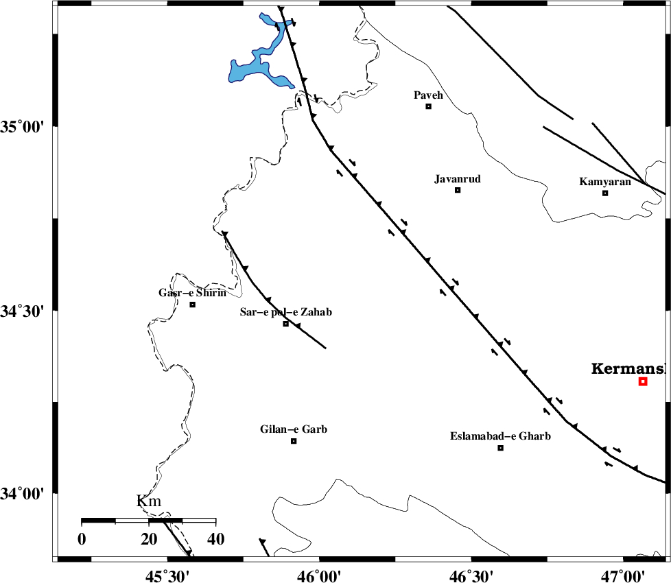
| Location | Lat:34.576 Lon: 46.139 |
| Region | Kermanshah Province, 26 km North-East of Sar-e pol-e zahab |
Nearest Cities |
|
| 17 km South of Qolqoleh, Kermanshah Province | |
| 17 km North of Rijab, Kermanshah Province | |
| 18 km North West of Zavleh olia, Kermanshah Province | |
| 20 km South West of Mirabad, Kermanshah Province | |
| 21 km East of Bazmirabad, Kermanshah Province | |
| Depth | 6 km |
| Agency | |
Faults within 150 km: |
|
| HZF4 (Length: 492 km) , Distance to epicenter: 21 km | |
| MFF8 (Length: 48 km) , Distance to epicenter: 23 km | |
| SARTAKHT_F (Length: 78 km) , Distance to epicenter: 72 km | |
| Number of Phases | 6 |
| RMS | 0.2 |
| Number of Stations | 4 |
| Error in Latitude | >1.4 km |
| Error in Longitude | 4.2 km |
| Error in Depth | 7.1 km |
Download waveform in seisan format
to download seisan software Click here
to access information about IIEES stations Click here
Amplitude | ||||||||
| UID | Agency | Station | Component | Amplitude | Period | Arrival Time | Proccessing Time | Signal Clip |
| 136406 | IIEES | ILBA | N | 89.4 | 0.31 | 2018-09-04 04:40:10 | 2018-09-05 06:07:00 | n |
| 136407 | IIEES | ILBA | E | 109.5 | 0.45 | 2018-09-04 04:40:11 | 2018-09-05 06:07:00 | n |
| 136408 | IIEES | SRSL | E | 54.2 | 0.44 | 2018-09-04 04:40:32 | 2018-09-05 06:07:00 | n |
| 136409 | IIEES | SRSL | N | 50.6 | 0.39 | 2018-09-04 04:40:34 | 2018-09-05 06:07:00 | n |
Phase | ||||||||||||
| Agency | Station | Component | Phase Type | Phase Quality | First Motion | Observed Arrival Time | Time Residual | Loc. Flag | Input Weight | Distance | Azimuth | |
| IIEES | ILBA | Z | Pg | E | 2018-09-04 04:39:50 | -0.2 | y | 106 | 177 | |||
| IIEES | ILBA | N | Sg | E | 2018-09-04 04:40:04 | 0.08 | y | 106 | 177 | |||
| IIEES | SNGE | Z | Pg | E | 2018-09-04 04:39:53 | -0.27 | y | 124 | 62 | |||
| IIEES | SRSL | Z | Pg | E | 2018-09-04 04:40:05 | 0 | y | 193 | 341 | |||
| IIEES | SRSL | N | Sg | E | 2018-09-04 04:40:29 | 0.04 | y | 193 | 341 | |||
| IIEES | ASAO | Z | Pn | E | 2018-09-04 04:40:25 | 0.42 | y | 357 | 89 | |||