
Magnitude |
2.6 |
| Date & Time (UTC) | 2018-10-04 14:10:24.7 |
| Date & Time (Local) | 1397/7/12 17:40:24.7 |
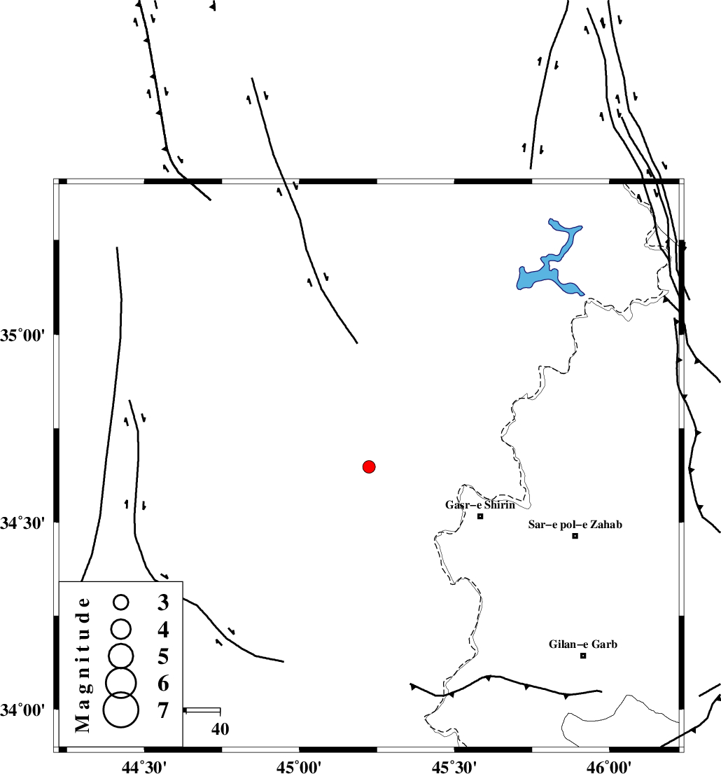
| Location | Lat:34.648 Lon: 45.224 |
| Region | Iraq, 36 km North-West of Qasr-E-Shirin |
Nearest Cities |
|
| 36 km North West of Khosravi, Kermanshah Province | |
| 36 km North West of Qasr-E-Shirin, Kermanshah Province | |
| 41 km North West of Seyyed sohrab, Kermanshah Province | |
| 42 km North West of Aqabarar, Kermanshah Province | |
| 47 km South West of Tappeh rash, Kermanshah Province | |
| Depth | 14 km |
| Agency | |
Faults within 150 km: |
|
| MFF8 (Length: 48 km) , Distance to epicenter: 42 km | |
| HZF4 (Length: 492 km) , Distance to epicenter: 80 km | |
| ZFF4 (Length: 128 km) , Distance to epicenter: 83 km | |
| Number of Phases | 5 |
| RMS | 0.2 |
| Number of Stations | 3 |
| Error in Latitude | >3.8 km |
| Error in Longitude | 8.1 km |
| Error in Depth | 9.1 km |
Download waveform in seisan format
to download seisan software Click here
to access information about IIEES stations Click here
Amplitude | ||||||||
| UID | Agency | Station | Component | Amplitude | Period | Arrival Time | Proccessing Time | Signal Clip |
| 137520 | IIEES | ILBA | N | 110.7 | 0.41 | 2018-10-04 14:11:10 | 2018-10-06 11:41:00 | n |
| 137521 | IIEES | ILBA | E | 105.2 | 0.41 | 2018-10-04 14:11:12 | 2018-10-06 11:41:00 | n |
Phase | ||||||||||||
| Agency | Station | Component | Phase Type | Phase Quality | First Motion | Observed Arrival Time | Time Residual | Loc. Flag | Input Weight | Distance | Azimuth | |
| IIEES | ILBA | Z | Pg | E | 2018-10-04 14:10:48 | -0.27 | y | 145 | 141 | |||
| IIEES | ILBA | N | Sg | E | 2018-10-04 14:11:06 | 0.16 | y | 145 | 141 | |||
| IIEES | SNGE | Z | Pn | E | 2018-10-04 14:10:57 | 0.24 | y | 200 | 75 | |||
| IIEES | SNGE | N | Sg | E | 2018-10-04 14:11:21 | -0.1 | y | 200 | 75 | |||
| IIEES | ASAO | Z | Pn | E | 2018-10-04 14:11:27 | -0.05 | y | 441 | 90 | |||