
Magnitude |
2.8 |
| Date & Time (UTC) | 2019-10-05 03:48:21.4 |
| Date & Time (Local) | 1398/7/13 07:18:21.4 |
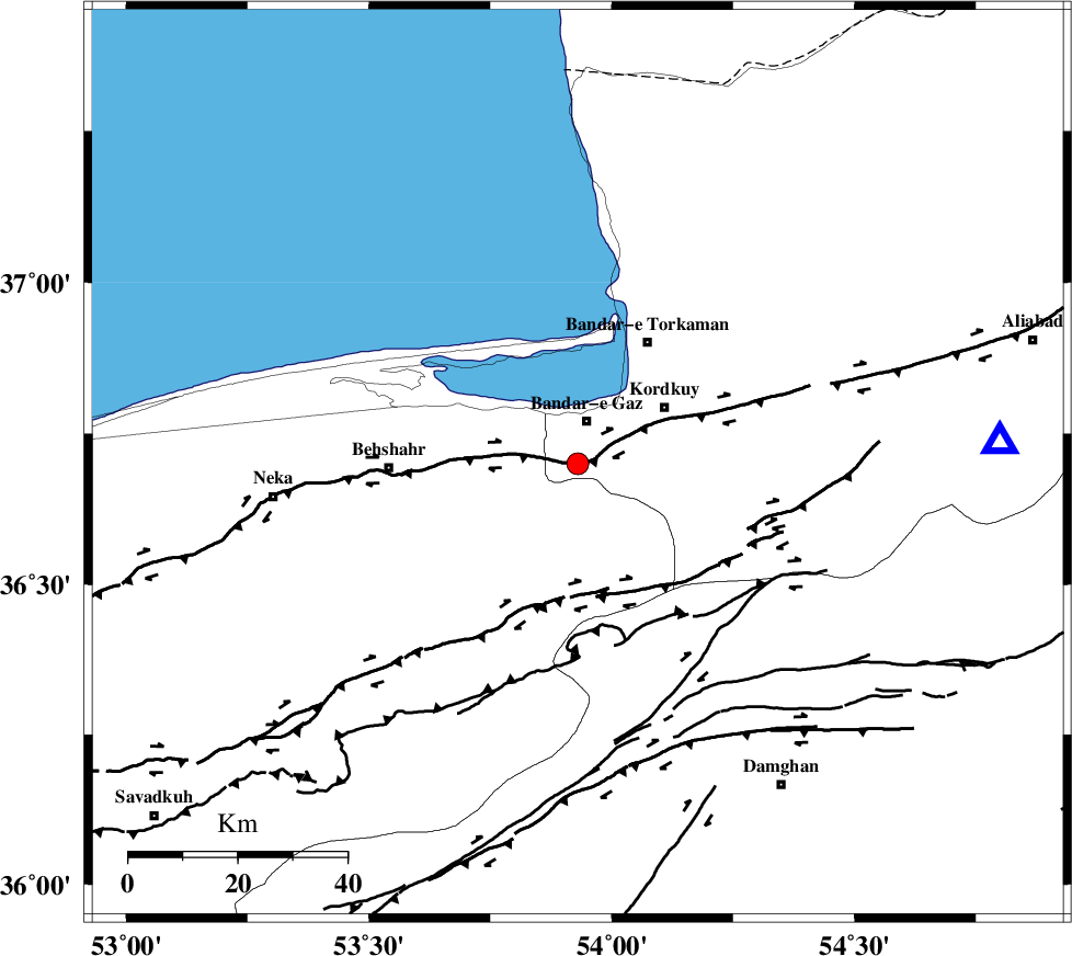
| Location | Lat:36.7 Lon: 53.93 |
| Region | Golestan Province, 8 km of Bandar-e gaz |
Nearest Cities |
|
| 3 km of Nokandeh, Golestan Province | |
| 4 km of Gaz-e gharbi, Golestan Province | |
| 8 km of Bandar-e gaz, Golestan Province | |
| 11 km East of Galugah, Mazandaran Province | |
| 12 km North of Sefid chah, Mazandaran Province | |
| Depth | 14 km |
| Agency | |
Faults within 150 km: |
|
| KHAZAR_F (Length: 523 km) , Distance to epicenter: 3 km | |
| N_ALBORZ_F (Length: 360 km) , Distance to epicenter: 22 km | |
| ASTANEH_F (Length: 72 km) , Distance to epicenter: 41 km | |
| Number of Phases | 7 |
| RMS | 0.8 |
| Number of Stations | 7 |
| Error in Latitude | >8 km |
| Error in Longitude | 0 km |
| Error in Depth | 26 km |
Download waveform in seisan format
to download seisan software Click here
to access information about IIEES stations Click here
Amplitude | ||||||||
| UID | Agency | Station | Component | Amplitude | Period | Arrival Time | Proccessing Time | Signal Clip |
| 146242 | IIEES SC | ANJ | Z | 170 | 1 | 2019-10-05 03:48:44 | 2019-10-05 02:40:00 | n |
| 146243 | IIEES SC | SHRO | Z | 37 | 1 | 2019-10-05 03:49:24 | 2019-10-05 02:40:00 | n |
| 146244 | IIEES SC | DAMV | Z | 35 | 1 | 2019-10-05 03:49:27 | 2019-10-05 02:40:00 | n |
| 146245 | IIEES SC | MRVT | Z | 59 | 1 | 2019-10-05 03:49:27 | 2019-10-05 02:40:00 | n |
| 146246 | IIEES SC | CHTH | Z | 32 | 1 | 2019-10-05 03:49:39 | 2019-10-05 02:40:00 | n |
| 146247 | IIEES SC | THKV | Z | 34 | 1 | 2019-10-05 03:49:46 | 2019-10-05 02:40:00 | n |
| 146248 | IIEES SC | QABG | Z | 3.4 | 1 | 2019-10-05 03:50:50 | 2019-10-05 02:40:00 | n |
Phase | ||||||||||||
| Agency | Station | Component | Phase Type | Phase Quality | First Motion | Observed Arrival Time | Time Residual | Loc. Flag | Input Weight | Distance | Azimuth | |
| IIEES SC | ANJ | Z | IP | I | 2019-10-05 03:48:43 | -0.6 | y | 133 | 181 | |||
| IIEES SC | SHRO | Z | IP | I | 2019-10-05 03:48:54 | 0.4 | y | 200 | 112 | |||
| IIEES SC | DAMV | Z | IP | I | 2019-10-05 03:48:54 | -1 | y | 211 | 236 | |||
| IIEES SC | MRVT | Z | IP | I | 2019-10-05 03:48:55 | -0.4 | y | 222 | 61 | |||
| IIEES SC | CHTH | Z | IP | I | 2019-10-05 03:49:02 | 0.5 | y | 266 | 251 | |||
| IIEES SC | THKV | Z | IP | I | 2019-10-05 03:49:06 | 1.2 | y | 289 | 252 | |||
| IIEES SC | QABG | Z | IP | I | 2019-10-05 03:49:22 | 2.4 | y | 411 | 254 | |||

 IIEES All Rights Reserved