
Magnitude |
3.1 |
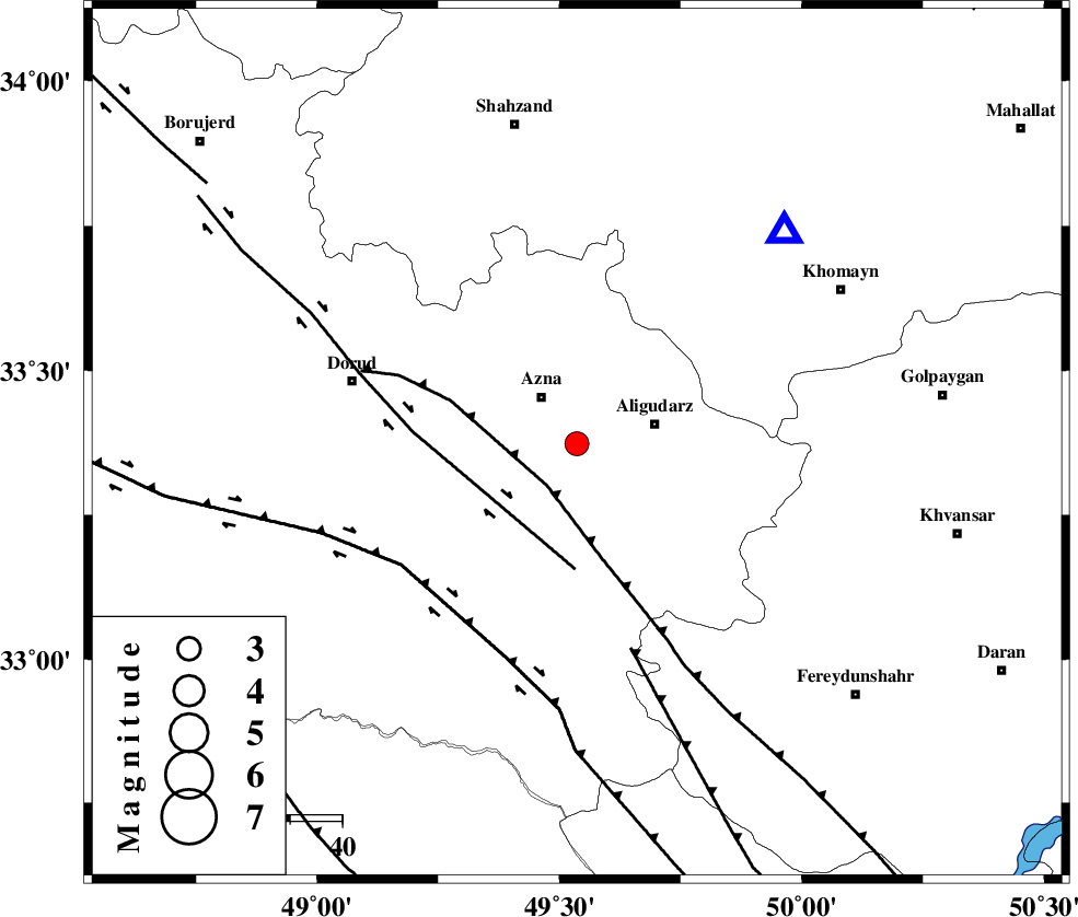
| Date & Time (UTC) | 2025-04-24 05:49:53.3 |
| Date & Time (Local) | 1404/2/4 09:19:53.3 |
| Location | Lat:33.374 Lon: 49.536 |
| Region | Lorestan Province, 11 km of Azna |
Nearest Cities |
|
| 6 km of Sur, Lorestan Province | |
| 11 km of Azna, Lorestan Province | |
| 15 km West of Aligudarz, Lorestan Province | |
| 19 km West of Khameh sofla, Lorestan Province | |
| 21 km North West of Shapoorabad, Lorestan Province | |
| Depth | 12 km |
| Agency | |
Faults within 150 km: |
|
| MAIN_ZAGROS_R_F (Length: 1106 km) , Distance to epicenter: 10 km | |
| DORUD (Length: 100 km) , Distance to epicenter: 24 km | |
| ARDAL_F (Length: 170 km) , Distance to epicenter: 41 km | |
| Number of Phases | 9 |
| RMS | 0.5 |
| Number of Stations | 9 |
| Error in Latitude | >6.1 km |
| Error in Longitude | 6.1 km |
| Error in Depth | 19.7 km |
Download waveform in seisan format
to download seisan software Click here
to access information about IIEES stations Click here
Amplitude | ||||||||
| UID | Agency | Station | Component | Amplitude | Period | Arrival Time | Proccessing Time | Signal Clip |
| 198004 | IIEES SC | GHVR | Z | 0.6 | 1 | 2025-04-24 05:50:26 | 2025-04-26 08:05:00 | n |
| 198005 | IIEES SC | NASN | Z | 0.08 | 1 | 2025-04-24 05:50:39 | 2025-04-26 08:05:00 | n |
| 198006 | IIEES SC | ABGH | Z | 0.01 | 1 | 2025-04-24 05:51:16 | 2025-04-26 08:05:00 | n |
Phase | ||||||||||||
| Agency | Station | Component | Phase Type | Phase Quality | First Motion | Observed Arrival Time | Time Residual | Loc. Flag | Input Weight | Distance | Azimuth | |
| IIEES SC | ASAO | Z | EPg | E | 2025-04-24 05:50:16 | -0.4 | y | 0 | 138 | 19 | ||
| IIEES SC | ASAO | Z | ESg | E | 2025-04-24 05:50:38 | 5 | n | 4 | 138 | 19 | ||
| IIEES SC | GHVR | Z | EPn | E | 2025-04-24 05:50:26 | 0.7 | y | 0 | 200 | 52 | ||
| IIEES SC | NASN | Z | EPn | E | 2025-04-24 05:50:39 | -0.9 | y | 0 | 312 | 102 | ||
| IIEES SC | DAMV | Z | EPn | E | 2025-04-24 05:50:38 | -5 | n | 4 | 336 | 42 | ||
| IIEES SC | GIDE | Z | EPn | E | 2025-04-24 05:50:50 | 0.4 | y | 0 | 395 | 4 | ||
| IIEES SC | YZKH | Z | EPn | E | 2025-04-24 05:51:02 | 0.4 | y | 0 | 486 | 103 | ||
| IIEES SC | SRSL | Z | EPn | E | 2025-04-24 05:51:02 | -0.2 | y | 0 | 490 | 310 | ||
| IIEES SC | ABGH | Z | EPn | E | 2025-04-24 05:51:16 | -0.1 | y | 0 | 608 | 52 | ||