
Magnitude |
3 |
| Date & Time (UTC) | 2025-06-29 09:46:39.2 |
| Date & Time (Local) | 1404/4/8 13:16:39.2 |
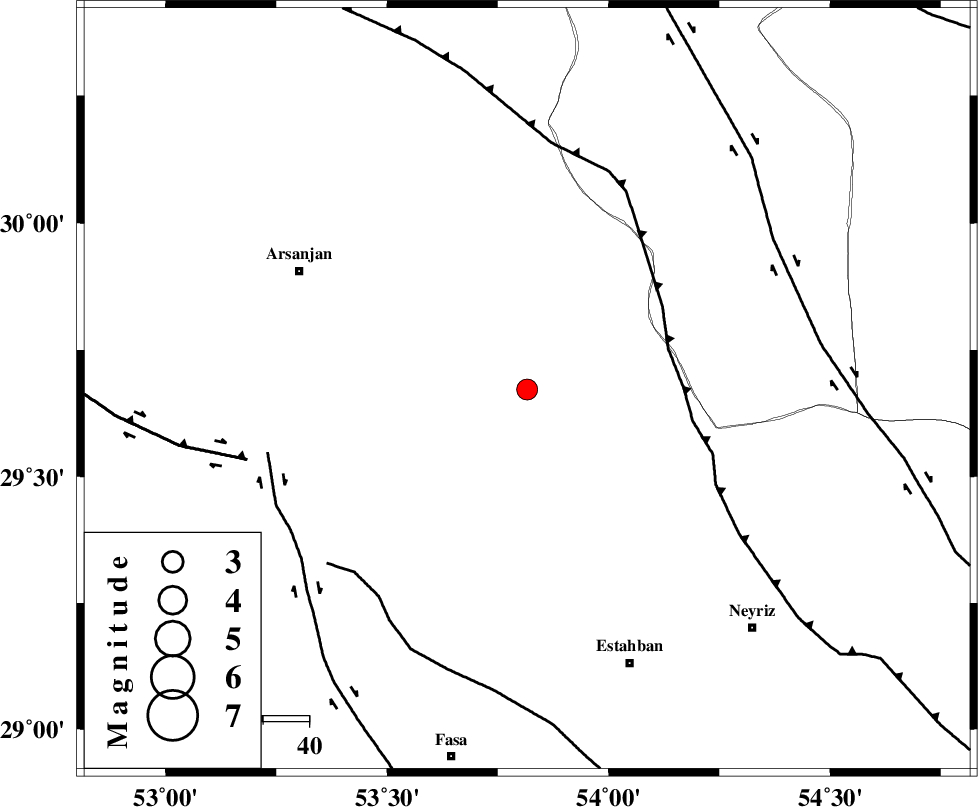
| Location | Lat:29.672 Lon: 53.816 |
| Region | Fars Province, 56 km South-East of Arsanjan |
Nearest Cities |
|
| 17 km South of Abadehtashk, Fars Province | |
| 30 km South West of Void, Fars Province | |
| 39 km South of Karehi, Fars Province | |
| 42 km South West of Khvansar, Yazd Province | |
| 46 km North East of Sofla, Fars Province | |
| Depth | 15 km |
| Agency | |
Faults within 150 km: |
|
| MAIN_ZAGROS_R_F (Length: 1106 km) , Distance to epicenter: 32 km | |
| BAKHTEGAN_F (Length: 94 km) , Distance to epicenter: 55 km | |
| SARVESTAN_F (Length: 94 km) , Distance to epicenter: 58 km | |
| Number of Phases | 7 |
| RMS | 0.2 |
| Number of Stations | 7 |
| Error in Latitude | >1.3 km |
| Error in Longitude | 1.3 km |
| Error in Depth | 4.1 km |
Download waveform in seisan format
to download seisan software Click here
to access information about IIEES stations Click here
Amplitude | ||||||||
| UID | Agency | Station | Component | Amplitude | Period | Arrival Time | Proccessing Time | Signal Clip |
| 198575 | IIEES SC | KRBR | Z | 0.09 | 1 | 2025-06-29 09:47:22 | 2025-07-01 06:18:00 | n |
| 198576 | IIEES SC | NASN | Z | 0.03 | 1 | 2025-06-29 09:47:31 | 2025-07-01 06:18:00 | n |
| 198577 | IIEES SC | UOSS | Z | 0.03 | 1 | 2025-06-29 09:47:58 | 2025-07-01 06:18:00 | n |
| 198578 | IIEES SC | UOSS | Z | 0.03 | 1 | 2025-06-29 09:48:55 | 2025-07-01 06:18:00 | n |
Phase | ||||||||||||
| Agency | Station | Component | Phase Type | Phase Quality | First Motion | Observed Arrival Time | Time Residual | Loc. Flag | Input Weight | Distance | Azimuth | |
| IIEES SC | GHIR | Z | EPg | E | 2025-06-29 09:47:07 | 0.1 | y | 0 | 174 | 208 | ||
| IIEES SC | GHIR | Z | ESg | E | 2025-06-29 09:47:28 | -0.2 | y | 0 | 174 | 208 | ||
| IIEES SC | KRBR | Z | EPn | E | 2025-06-29 09:47:22 | -0.1 | y | 0 | 287 | 83 | ||
| IIEES SC | NASN | Z | EPn | E | 2025-06-29 09:47:31 | 0.1 | y | 0 | 360 | 345 | ||
| IIEES SC | UOSS | Z | EPn | E | 2025-06-29 09:47:58 | 0.6 | y | 0 | 575 | 156 | ||
| IIEES SC | UOSS | Z | ES | E | 2025-06-29 09:48:55 | 0 | y | 0 | 575 | 156 | ||
| IIEES SC | ASAO | Z | EPn | E | 2025-06-29 09:49:14 | 67.1 | n | 4 | 648 | 327 | ||