
Magnitude |
3.5 |
| Date & Time (UTC) | 2025-10-30 00:10:47.7 |
| Date & Time (Local) | 1404/8/8 03:40:47.7 |
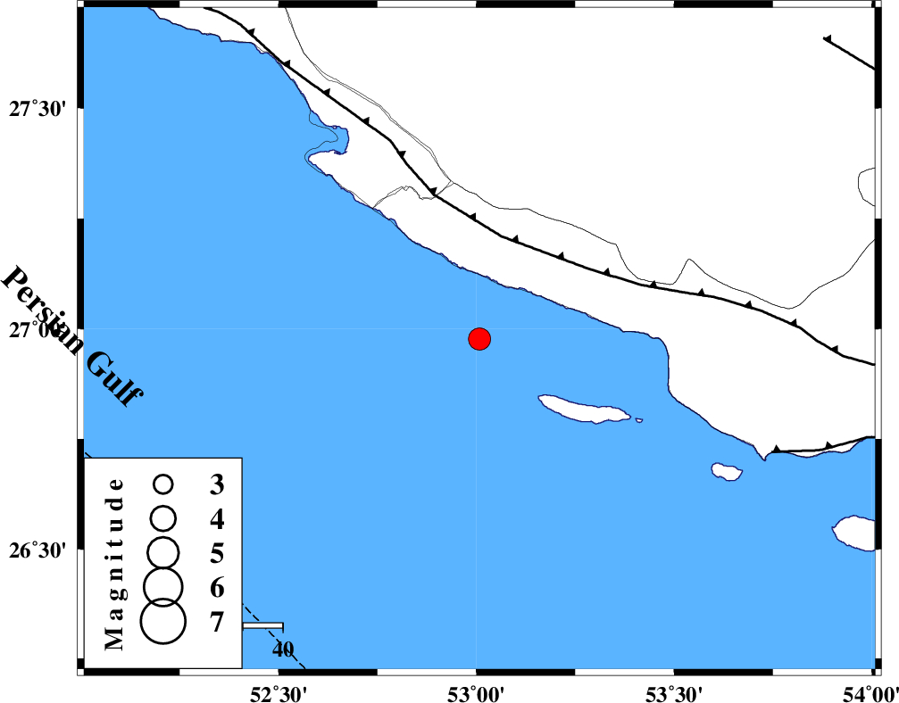
| Location | Lat:26.977 Lon: 53.008 |
| Region | Persian Gulf, 43 km South-West of Lamerd |
Nearest Cities |
|
| 43 km South West of Lamerd, Fars Province | |
| 48 km South East of Chah-e mobarak, Bushehr Province | |
| 52 km South of Khoozi, Fars Province | |
| 64 km South East of Mehr, Fars Province | |
| 66 km South West of Ashkenan, Fars Province | |
| Depth | 12 km |
| Agency | |
Faults within 150 km: |
|
| MFF3 (Length: 292 km) , Distance to epicenter: 26 km | |
| ZFF1 (Length: 165 km) , Distance to epicenter: 79 km | |
| MFF1 (Length: 180 km) , Distance to epicenter: 104 km | |
| Number of Phases | 10 |
| RMS | 0.2 |
| Number of Stations | 10 |
| Error in Latitude | >2.3 km |
| Error in Longitude | 2.3 km |
| Error in Depth | 7.8 km |
Download waveform in seisan format
to download seisan software Click here
to access information about IIEES stations Click here
Amplitude | ||||||||
| UID | Agency | Station | Component | Amplitude | Period | Arrival Time | Proccessing Time | Signal Clip |
| 199917 | IIEES SC | UOSS | Z | 0.06 | 1 | 2025-10-30 00:11:44 | 2025-11-01 05:47:00 | n |
| 199918 | IIEES SC | KRBR | Z | 0.1 | 1 | 2025-10-30 00:11:57 | 2025-11-01 05:47:00 | n |
| 199919 | IIEES SC | ZHSF | Z | 0.008 | 1 | 2025-10-30 00:12:36 | 2025-11-01 05:47:00 | n |
| 199920 | IIEES SC | TABS | Z | 0.01 | 1 | 2025-10-30 00:12:39 | 2025-11-01 05:47:00 | n |
Phase | ||||||||||||
| Agency | Station | Component | Phase Type | Phase Quality | First Motion | Observed Arrival Time | Time Residual | Loc. Flag | Input Weight | Distance | Azimuth | |
| IIEES SC | GHIR | Z | EPg | E | 2025-10-30 00:11:11 | 0.2 | y | 0 | 145 | 359 | ||
| IIEES SC | UOSS | Z | EPn | E | 2025-10-30 00:11:44 | -0.1 | y | 0 | 391 | 125 | ||
| IIEES SC | KRBR | Z | EPn | E | 2025-10-30 00:11:57 | 0.2 | y | 0 | 496 | 48 | ||
| IIEES SC | MEH | Z | EPn | E | 2025-10-30 00:11:59 | 0 | y | 0 | 513 | 18 | ||
| IIEES SC | IRSR | Z | EPn | E | 2025-10-30 00:12:32 | 0.1 | y | 0 | 780 | 90 | ||
| IIEES SC | ZHSF | Z | EPn | E | 2025-10-30 00:12:36 | -0.1 | y | 0 | 815 | 69 | ||
| IIEES SC | TABS | Z | EPn | E | 2025-10-30 00:12:39 | -0.7 | y | 0 | 839 | 28 | ||
| IIEES SC | ASAO | Z | EPn | E | 2025-10-30 00:12:45 | -0.6 | y | 0 | 887 | 341 | ||
| IIEES SC | SHRT | Z | EPn | E | 2025-10-30 00:13:02 | 0.5 | y | 0 | 1018 | 43 | ||
| IIEES SC | SRSL | Z | EPn | E | 2025-10-30 00:13:28 | -2.2 | n | 4 | 1251 | 325 | ||