
Magnitude |
3 |
| Date & Time (UTC) | 2025-11-28 07:00:14.5 |
| Date & Time (Local) | 1404/9/7 10:30:14.5 |
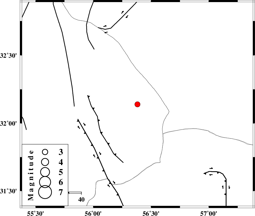
| Location | Lat:32.139 Lon: 56.382 |
| Region | Yazd Province, 105 km North-West of Ravar |
Nearest Cities |
|
| 45 km North East of Behabad, Yazd Province | |
| 53 km North East of Benestan, Yazd Province | |
| 54 km North East of Asfih, Yazd Province | |
| 72 km North East of Kushk, Yazd Province | |
| 81 km North of Kuhbanan, Kerman Province | |
| Depth | 12 km |
| Agency | |
Faults within 150 km: |
|
| JAFARABAD_F (Length: 60 km) , Distance to epicenter: 34 km | |
| KUHBANAN_F (Length: 189 km) , Distance to epicenter: 50 km | |
| SARBALA_F (Length: 92 km) , Distance to epicenter: 51 km | |
| Number of Phases | 9 |
| RMS | 0 |
| Number of Stations | 9 |
| Error in Latitude | >0.1 km |
| Error in Longitude | 0.1 km |
| Error in Depth | 0.8 km |
Download waveform in seisan format
to download seisan software Click here
to access information about IIEES stations Click here
Amplitude | ||||||||
| UID | Agency | Station | Component | Amplitude | Period | Arrival Time | Proccessing Time | Signal Clip |
| 200358 | IIEES SC | NASN | Z | 0.04 | 1 | 2025-11-28 07:01:05 | 2025-11-30 06:09:00 | n |
| 200359 | IIEES SC | SHRT | Z | 0.04 | 1 | 2025-11-28 07:01:12 | 2025-11-30 06:09:00 | n |
| 200360 | IIEES SC | SHRO | Z | 0.04 | 1 | 2025-11-28 07:01:15 | 2025-11-30 06:09:00 | n |
Phase | ||||||||||||
| Agency | Station | Component | Phase Type | Phase Quality | First Motion | Observed Arrival Time | Time Residual | Loc. Flag | Input Weight | Distance | Azimuth | |
| IIEES SC | YZKH | Z | EPg | E | 2025-11-28 07:00:42 | 0 | y | 0 | 171 | 279 | ||
| IIEES SC | YZKH | Z | ESg | E | 2025-11-28 07:01:03 | 0 | y | 0 | 171 | 279 | ||
| IIEES SC | TABS | Z | EPg | E | 2025-11-28 07:00:44 | 0 | y | 0 | 181 | 22 | ||
| IIEES SC | BSRN | Z | EPn | E | 2025-11-28 07:00:51 | -3.3 | n | 4 | 260 | 94 | ||
| IIEES SC | NASN | Z | EPn | E | 2025-11-28 07:01:05 | 0 | y | 0 | 344 | 282 | ||
| IIEES SC | SHRT | Z | EPn | E | 2025-11-28 07:01:12 | 0.1 | y | 0 | 402 | 65 | ||
| IIEES SC | SHRO | Z | EPn | E | 2025-11-28 07:01:15 | 0 | y | 0 | 430 | 355 | ||
| IIEES SC | SHRO | Z | ES | E | 2025-11-28 07:01:24 | -36.8 | n | 4 | 430 | 355 | ||
| IIEES SC | ZHSF | Z | EPn | E | 2025-11-28 07:01:25 | 0 | y | 0 | 504 | 124 | ||