
Magnitude |
3.5 |
| Date & Time (UTC) | 2025-12-01 12:28:43.3 |
| Date & Time (Local) | 1404/9/10 15:58:43.3 |
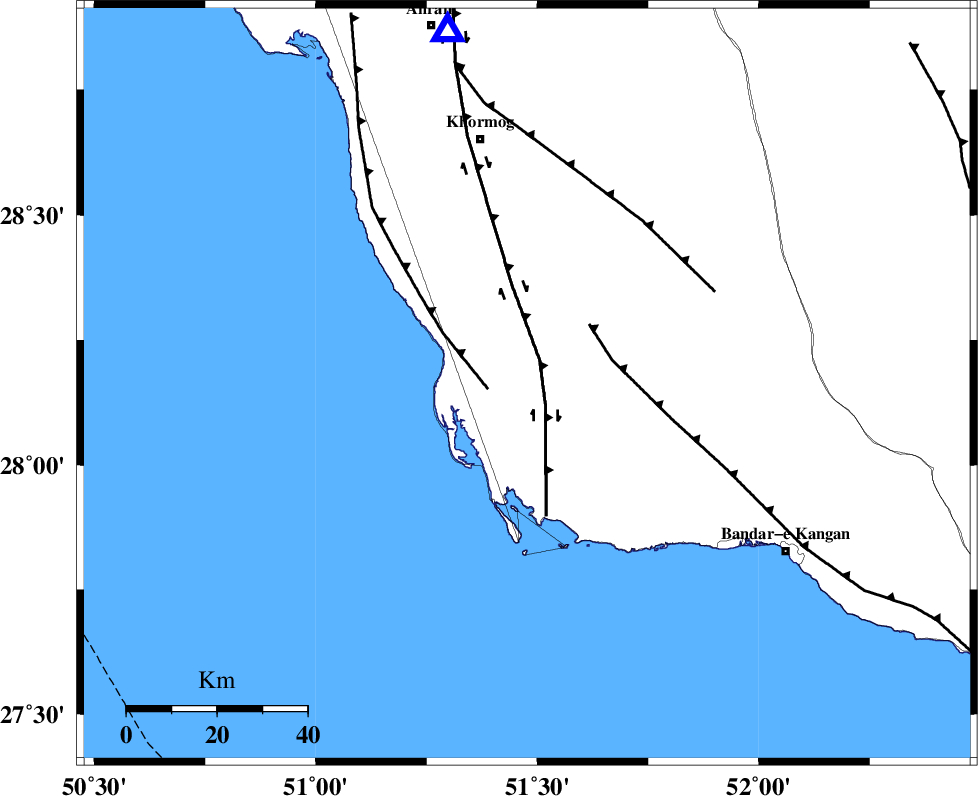
| Location | Lat:28.162 Lon: 51.477 |
| Region | Bushehr Province, 55 km South-East of Khormog |
Nearest Cities |
|
| 5 km of Abkesh, Bushehr Province | |
| 11 km East of Ziyarat, Bushehr Province | |
| 12 km North of Bardkhun, Bushehr Province | |
| 20 km South of Kaki, Bushehr Province | |
| 26 km South of Baduleh, Bushehr Province | |
| Depth | 12 km |
| Agency | |
Faults within 150 km: |
|
| BORAZJAN_F (Length: 168 km) , Distance to epicenter: 6 km | |
| ZFF2 (Length: 84 km) , Distance to epicenter: 9 km | |
| MFF3 (Length: 292 km) , Distance to epicenter: 19 km | |
| Number of Phases | 5 |
| RMS | 0.2 |
| Number of Stations | 5 |
| Error in Latitude | >28.2 km |
| Error in Longitude | 51.5 km |
| Error in Depth | 12 km |
Download waveform in seisan format
to download seisan software Click here
to access information about IIEES stations Click here
Amplitude | ||||||||
| UID | Agency | Station | Component | Amplitude | Period | Arrival Time | Proccessing Time | Signal Clip |
| 200462 | IIEES SC | NASN | Z | 0.03 | 1 | 2025-12-01 12:29:57 | 2025-12-06 07:27:00 | n |
| 200463 | IIEES SC | YZKH | Z | 0.07 | 1 | 2025-12-01 12:30:01 | 2025-12-06 07:27:00 | n |
| 200464 | IIEES SC | TABS | Z | 0.01 | 1 | 2025-12-01 12:30:32 | 2025-12-06 07:27:00 | n |
Phase | ||||||||||||
| Agency | Station | Component | Phase Type | Phase Quality | First Motion | Observed Arrival Time | Time Residual | Loc. Flag | Input Weight | Distance | Azimuth | |
| IIEES SC | GHIR | Z | EPg | E | 2025-12-01 12:29:07 | 0 | y | 0 | 149 | 85 | ||
| IIEES SC | NASN | Z | EPn | E | 2025-12-01 12:29:57 | -0.2 | y | 0 | 530 | 14 | ||
| IIEES SC | YZKH | Z | EPn | E | 2025-12-01 12:30:01 | 0.6 | y | 0 | 556 | 33 | ||
| IIEES SC | UOSS | Z | EPn | E | 2025-12-01 12:30:00 | -3.6 | n | 4 | 591 | 127 | ||
| IIEES SC | TABS | Z | EPn | E | 2025-12-01 12:30:32 | -0.1 | y | 0 | 813 | 42 | ||