
Magnitude |
3.4 |
| Date & Time (UTC) | 2026-01-31 08:00:57.9 |
| Date & Time (Local) | 1404/11/11 11:30:57.9 |
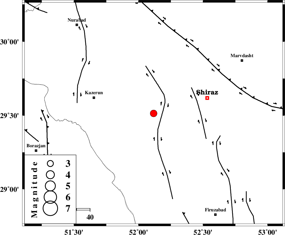
| Location | Lat:29.514 Lon: 52.117 |
| Region | Fars Province, 42 km South-West of Shiraz |
Nearest Cities |
|
| 5 km North of Richi, Fars Province | |
| 20 km South West of Khanehzanian, Fars Province | |
| 25 km East of Kalani, Fars Province | |
| 31 km North East of Baladeh, Fars Province | |
| 33 km North East of Dadin-e olia, Fars Province | |
| Depth | 12 km |
| Agency | |
Faults within 150 km: |
|
| KAREBASS_F (Length: 98 km) , Distance to epicenter: 8 km | |
| SABZ_PUSHAN_F_Z3 (Length: 37 km) , Distance to epicenter: 34 km | |
| SABZ_PUSHAN_F_Z1 (Length: 69 km) , Distance to epicenter: 52 km | |
| Number of Phases | 5 |
| RMS | 0.2 |
| Number of Stations | 5 |
| Error in Latitude | >2.2 km |
| Error in Longitude | 2.2 km |
| Error in Depth | 14.3 km |
Download waveform in seisan format
to download seisan software Click here
to access information about IIEES stations Click here
Amplitude | ||||||||
| UID | Agency | Station | Component | Amplitude | Period | Arrival Time | Proccessing Time | Signal Clip |
| 201270 | IIEES SC | AMS1 | Z | 0.2 | 1 | 2026-01-31 08:01:53 | 2026-02-01 06:12:00 | n |
| 201271 | IIEES SC | KRVR | Z | 0.03 | 1 | 2026-01-31 08:02:09 | 2026-02-01 06:12:00 | n |
| 201272 | IIEES SC | TABS | Z | 0.02 | 1 | 2026-01-31 08:02:27 | 2026-02-01 06:12:00 | n |
Phase | ||||||||||||
| Agency | Station | Component | Phase Type | Phase Quality | First Motion | Observed Arrival Time | Time Residual | Loc. Flag | Input Weight | Distance | Azimuth | |
| IIEES SC | GHIR | Z | EPg | E | 2026-01-31 08:01:24 | 0 | y | 0 | 160 | 148 | ||
| IIEES SC | AMS1 | Z | EPn | E | 2026-01-31 08:01:53 | 0.1 | y | 0 | 384 | 317 | ||
| IIEES SC | KRVR | Z | EPn | E | 2026-01-31 08:02:09 | 0.1 | y | 0 | 513 | 62 | ||
| IIEES SC | SFB | Z | EPn | E | 2026-01-31 08:02:12 | -0.5 | y | 0 | 537 | 1 | ||
| IIEES SC | TABS | Z | EPn | E | 2026-01-31 08:02:27 | -0.3 | y | 0 | 660 | 46 | ||