
Magnitude |
3.5 |
| Date & Time (UTC) | 2008-06-01 05:05:56.4 |
| Date & Time (Local) | 1387/3/12 09:35:56.4 |
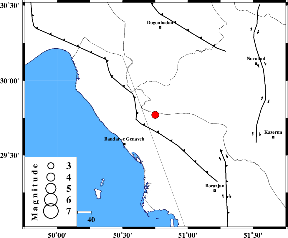
| Location | Lat:29.77 Lon: 50.75 |
| Region | 31 km North-East of Bandar-e genaveh, Bushehr Province |
Nearest Cities |
|
| 19 km North East of Mohammad salehi, Bushehr Province | |
| 25 km North of Chehar rustaee, Bushehr Province | |
| 32 km North East of Bandar-e genaveh, Bushehr Province | |
| 34 km North East of Bandarehrig, Bushehr Province | |
| 40 km North West of Dehkohneh, Bushehr Province | |
| Depth | 12 km |
| Agency | |
Faults within 150 km: |
|
| ZFF3 (Length: 125 km) , Distance to epicenter: 13 km | |
| BORAZJAN_F (Length: 168 km) , Distance to epicenter: 54 km | |
| RAG_E_SEFID_F (Length: 84 km) , Distance to epicenter: 55 km | |
| Number of Phases | 5 |
| RMS | 0.1 |
| Number of Stations | 4 |
| Error in Latitude | >5.2 km |
| Error in Longitude | 9.4 km |
| Error in Depth | 7.9 km |
Download waveform in seisan format
to download seisan software Click here
to access information about IIEES stations Click here
Amplitude | ||||||||
| UID | Agency | Station | Component | Amplitude | Period | Arrival Time | Proccessing Time | Signal Clip |
| 49286 | IIEES | GHIR | N | 161.7 | 0.58 | 2008-06-01 05:07:29 | 2009-01-18 12:56:00 | n |
| 49287 | IIEES | ASAO | N | 33.1 | 0.57 | 2008-06-01 05:08:13 | 2009-01-18 12:56:00 | n |
| 49288 | IIEES | KRBR | N | 29.4 | 0.55 | 2008-06-01 05:08:25 | 2009-01-18 12:56:00 | n |
| 49289 | IIEES | KRBR | E | 26.1 | 0.41 | 2008-06-01 05:08:27 | 2009-01-18 12:56:00 | n |
Phase | ||||||||||||
| Agency | Station | Component | Phase Type | Phase Quality | First Motion | Observed Arrival Time | Time Residual | Loc. Flag | Input Weight | Distance | Azimuth | |
| IIEES | GHIR | Z | Pn | E | 2008-06-01 05:06:38 | 0 | y | 273 | 126 | |||
| IIEES | GHIR | N | Sn | 2008-06-01 05:07:08 | 0 | y | 273 | 126 | ||||
| IIEES | ASAO | Z | Pn | E | 2008-06-01 05:07:10 | -0.1 | y | 534 | 353 | |||
| IIEES | KRBR | Z | Pn | E | 2008-06-01 05:07:16 | -0.1 | y | 581 | 86 | |||
| IIEES | DAMV | Z | Pn | E | 2008-06-01 05:07:26 | 0.2 | y | 660 | 10 | |||