
Magnitude |
2.7 |
| Date & Time (UTC) | 2008-11-06 10:44:24.3 |
| Date & Time (Local) | 1387/8/16 14:14:24.3 |
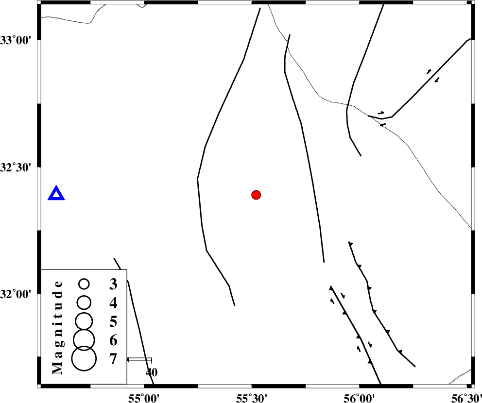
| Location | Lat:32.39 Lon: 55.52 |
| Region | 88 km North-East of Bafq, Yazd Province |
Nearest Cities |
|
| 70 km South of Robat-e posht-e badam, Yazd Province | |
| 75 km North West of Behabad, Yazd Province | |
| 77 km North West of Kushk, Yazd Province | |
| 81 km North East of Kharaneq, Yazd Province | |
| 86 km North of Mobarake, Yazd Province | |
| Depth | 14 km |
| Agency | |
Faults within 150 km: |
|
| SARBALA_F (Length: 92 km) , Distance to epicenter: 25 km | |
| POSHT_E_BADAM_F (Length: 128 km) , Distance to epicenter: 26 km | |
| JAFARABAD_F (Length: 60 km) , Distance to epicenter: 45 km | |
| Number of Phases | 4 |
| RMS | 0.1 |
| Number of Stations | 3 |
| Error in Latitude | >3.8 km |
| Error in Longitude | 1.5 km |
| Error in Depth | 6.2 km |
Download waveform in seisan format
to download seisan software Click here
to access information about IIEES stations Click here
Amplitude | ||||||||
| UID | Agency | Station | Component | Amplitude | Period | Arrival Time | Proccessing Time | Signal Clip |
| 51107 | IIEES | NASN | E | 38.4 | 0.48 | 2008-11-06 10:45:41 | 2009-05-17 10:07:00 | n |
| 51108 | IIEES | NASN | N | 37.2 | 0.48 | 2008-11-06 10:45:41 | 2009-05-17 10:07:00 | n |
| 51109 | IIEES | KRBR | N | 53.3 | 0.65 | 2008-11-06 10:45:54 | 2009-05-17 10:07:00 | n |
Phase | ||||||||||||
| Agency | Station | Component | Phase Type | Phase Quality | First Motion | Observed Arrival Time | Time Residual | Loc. Flag | Input Weight | Distance | Azimuth | |
| IIEES | TABS | Z | Pg | E | 2008-11-06 10:44:57 | 0 | y | 204 | 47 | |||
| IIEES | NASN | Z | Pn | E | 2008-11-06 10:45:04 | 0.1 | y | 259 | 281 | |||
| IIEES | NASN | N | Sg | E | 2008-11-06 10:45:37 | -0.1 | y | 259 | 281 | |||
| IIEES | KRBR | Z | Pn | E | 2008-11-06 10:45:08 | 0 | y | 292 | 156 | |||