
Magnitude |
3 |
| Date & Time (UTC) | 2009-03-12 19:13:06.1 |
| Date & Time (Local) | 1387/12/22 22:43:06.1 |
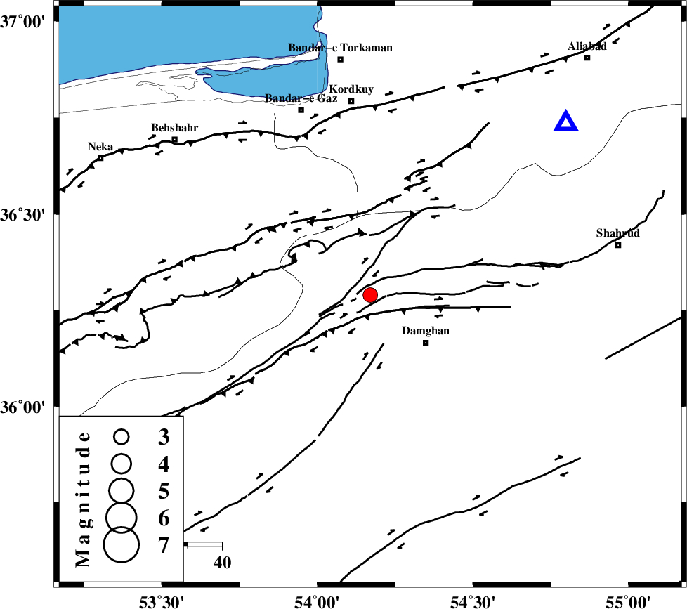
| Location | Lat:36.29 Lon: 54.17 |
| Region | 20 km North-West of Damghan, Semnan Province |
Nearest Cities |
|
| 21 km North West of Damghan, Semnan Province | |
| 26 km North of Seydabad, Semnan Province | |
| 29 km North of Amirabad, Semnan Province | |
| 36 km North West of Mehmandust, Semnan Province | |
| 39 km South West of Cheharbagh, Golestan Province | |
| Depth | 14 km |
| Agency | |
Faults within 150 km: |
|
| ASTANEH_F (Length: 72 km) , Distance to epicenter: 6 km | |
| DAMGHAN_F (Length: 95 km) , Distance to epicenter: 11 km | |
| ATARI_F (Length: 185 km) , Distance to epicenter: 16 km | |
| Number of Phases | 7 |
| RMS | 0.3 |
| Number of Stations | 7 |
| Error in Latitude | >7.7 km |
| Error in Longitude | 4.5 km |
| Error in Depth | 10.7 km |
Download waveform in seisan format
to download seisan software Click here
to access information about IIEES stations Click here
Amplitude | ||||||||
| UID | Agency | Station | Component | Amplitude | Period | Arrival Time | Proccessing Time | Signal Clip |
| 52167 | IIEES | DAMV | E | 139.6 | 0.52 | 2009-03-12 19:14:13 | 2009-06-27 08:52:00 | n |
| 52168 | IIEES | DAMV | N | 104.6 | 0.36 | 2009-03-12 19:14:15 | 2009-06-27 08:52:00 | n |
| 52169 | IIEES | MRVT | E | 83.2 | 0.52 | 2009-03-12 19:14:16 | 2009-06-27 08:52:00 | n |
| 52170 | IIEES | MRVT | N | 94.9 | 0.4 | 2009-03-12 19:14:21 | 2009-06-27 08:52:00 | n |
| 52171 | IIEES | GHVR | E | 54.4 | 0.52 | 2009-03-12 19:14:46 | 2009-06-27 08:52:00 | n |
| 52172 | IIEES | GHVR | N | 60 | 0.52 | 2009-03-12 19:14:48 | 2009-06-27 08:52:00 | n |
Phase | ||||||||||||
| Agency | Station | Component | Phase Type | Phase Quality | First Motion | Observed Arrival Time | Time Residual | Loc. Flag | Input Weight | Distance | Azimuth | |
| IIEES | DAMV | Z | Pg | E | 2009-03-12 19:13:40 | -0.3 | y | 212 | 251 | |||
| IIEES | MRVT | Z | Pg | E | 2009-03-12 19:13:43 | -0.1 | y | 229 | 48 | |||
| IIEES | CHTH | E | Sg | E | 2009-03-12 19:14:24 | 0.2 | y | 278 | 262 | |||
| IIEES | GHVR | Z | Pn | E | 2009-03-12 19:13:55 | -0.2 | y | 333 | 234 | |||
| IIEES | TABS | Z | Pn | E | 2009-03-12 19:14:03 | 0.5 | y | 397 | 137 | |||
| IIEES | NASN | Z | Pn | E | 2009-03-12 19:14:04 | -0.3 | y | 406 | 198 | |||
| IIEES | ZNJK | Z | Pn | E | 2009-03-12 19:14:15 | 0.4 | y | 494 | 277 | |||