
Magnitude |
3 |
| Date & Time (UTC) | 2009-03-14 21:23:45.4 |
| Date & Time (Local) | 1387/12/25 00:53:45.4 |
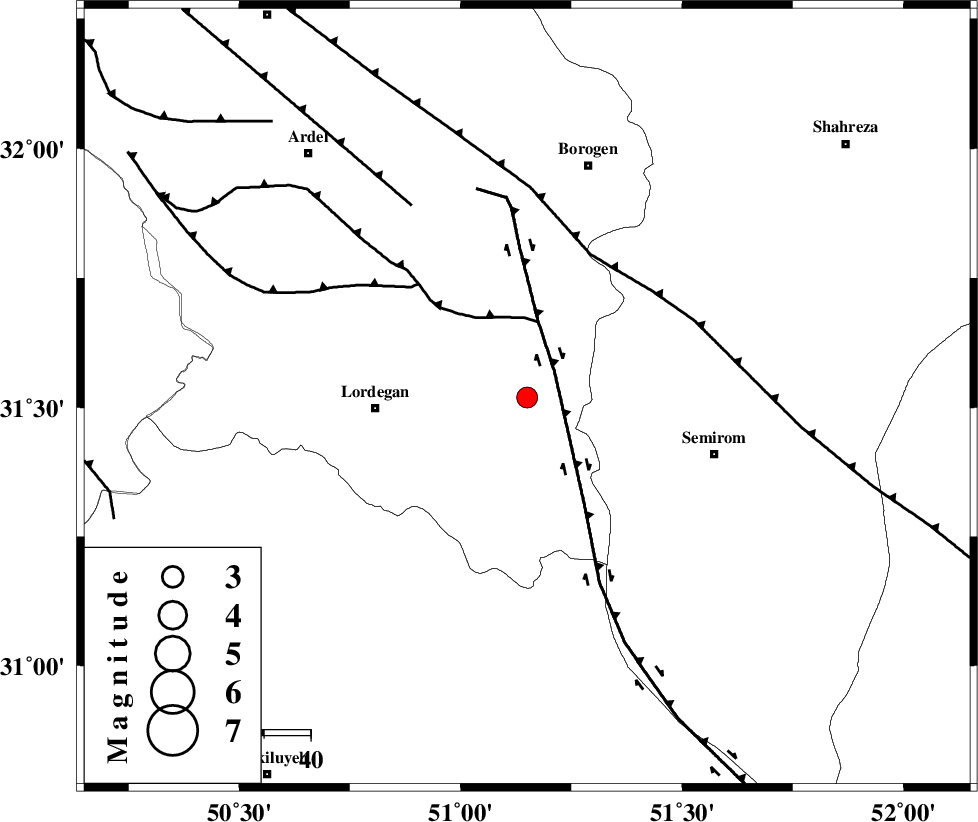
| Location | Lat:31.52 Lon: 51.15 |
| Region | 32 km East of Lordegan, Chaharmahal Bakhtiari Province |
Nearest Cities |
|
| 9 km of Aluni, Chaharmahal Bakhtiari Province | |
| 17 km West of Vanak, Esfahan Province | |
| 30 km North West of Malkhalifeh, Chaharmahal Bakhtiari Province | |
| 32 km North East of Sardasht, Chaharmahal Bakhtiari Province | |
| 33 km North East of Lordegan, Chaharmahal Bakhtiari Province | |
| Depth | 14 km |
| Agency | |
Faults within 150 km: |
|
| DENA_F (Length: 137 km) , Distance to epicenter: 8 km | |
| DOPOLAN_F (Length: 107 km) , Distance to epicenter: 16 km | |
| MAIN_ZAGROS_R_F (Length: 1106 km) , Distance to epicenter: 34 km | |
| Number of Phases | 7 |
| RMS | 0.4 |
| Number of Stations | 5 |
| Error in Latitude | >6.2 km |
| Error in Longitude | 5.4 km |
| Error in Depth | 12.9 km |
Download waveform in seisan format
to download seisan software Click here
to access information about IIEES stations Click here
Amplitude | ||||||||
| UID | Agency | Station | Component | Amplitude | Period | Arrival Time | Proccessing Time | Signal Clip |
| 52192 | IIEES | SHGR | N | 111.5 | 0.6 | 2009-03-14 21:25:04 | 2009-06-27 08:52:00 | n |
| 52193 | IIEES | SHGR | E | 109.2 | 0.76 | 2009-03-14 21:25:15 | 2009-06-27 08:52:00 | n |
| 52194 | IIEES | GHVR | E | 35.8 | 0.68 | 2009-03-14 21:25:27 | 2009-06-27 08:52:00 | n |
| 52195 | IIEES | GHVR | N | 47.4 | 0.72 | 2009-03-14 21:25:38 | 2009-06-27 08:52:00 | n |
Phase | ||||||||||||
| Agency | Station | Component | Phase Type | Phase Quality | First Motion | Observed Arrival Time | Time Residual | Loc. Flag | Input Weight | Distance | Azimuth | |
| IIEES | NASN | Z | Pg | E | 2009-03-14 21:24:19 | -0.3 | y | 211 | 47 | |||
| IIEES | NASN | N | Sg | E | 2009-03-14 21:24:45 | -0.2 | y | 211 | 47 | |||
| IIEES | SHGR | Z | Pg | E | 2009-03-14 21:24:22 | -0.8 | y | 232 | 287 | |||
| IIEES | KHMZ | Z | Pn | E | 2009-03-14 21:24:27 | 0.4 | y | 270 | 336 | |||
| IIEES | KHMZ | E | Sg | E | 2009-03-14 21:25:02 | 0.4 | y | 270 | 336 | |||
| IIEES | GHVR | Z | Pn | E | 2009-03-14 21:24:34 | 0.3 | y | 328 | 2 | |||
| IIEES | GHIR | Z | Pn | E | 2009-03-14 21:24:43 | 0.4 | y | 400 | 153 | |||