
Magnitude |
3.5 |
| Date & Time (UTC) | 2009-04-02 13:19:36.1 |
| Date & Time (Local) | 1388/1/13 17:49:36.1 |
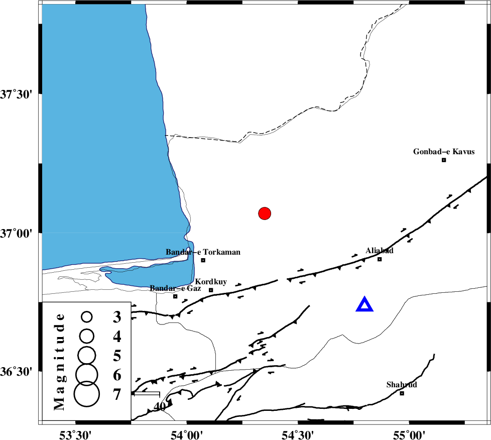
| Location | Lat:37.07 Lon: 54.35 |
| Region | 11 km West of Aq Qaleh, Golestan Province |
Nearest Cities |
|
| 11 km North West of Aq Qaleh, Golestan Province | |
| 13 km North East of Banavar, Golestan Province | |
| 15 km North West of Qanqarmeh, Golestan Province | |
| 24 km North West of Nodeh malek, Golestan Province | |
| 24 km East of Gomishtappeh, Golestan Province | |
| Depth | 15 km |
| Agency | |
Faults within 150 km: |
|
| KHAZAR_F (Length: 523 km) , Distance to epicenter: 28 km | |
| N_ALBORZ_F (Length: 360 km) , Distance to epicenter: 51 km | |
| SHAVAR_F (Length: 87 km) , Distance to epicenter: 56 km | |
| Number of Phases | 7 |
| RMS | 0.4 |
| Number of Stations | 7 |
| Error in Latitude | >7.8 km |
| Error in Longitude | 3.5 km |
| Error in Depth | 0 km |
Download waveform in seisan format
to download seisan software Click here
to access information about IIEES stations Click here
Amplitude | ||||||||
| UID | Agency | Station | Component | Amplitude | Period | Arrival Time | Proccessing Time | Signal Clip |
| 52341 | IIEES | MRVT | E | 531.8 | 0.2 | 2009-04-02 13:20:30 | 2009-07-13 01:52:00 | n |
| 52342 | IIEES | MRVT | N | 538.5 | 0.2 | 2009-04-02 13:20:31 | 2009-07-13 01:52:00 | n |
| 52343 | IIEES | GHVR | E | 111.6 | 0.76 | 2009-04-02 13:21:37 | 2009-07-13 01:52:00 | n |
| 52344 | IIEES | GHVR | N | 109 | 0.64 | 2009-04-02 13:21:39 | 2009-07-13 01:52:00 | n |
Phase | ||||||||||||
| Agency | Station | Component | Phase Type | Phase Quality | First Motion | Observed Arrival Time | Time Residual | Loc. Flag | Input Weight | Distance | Azimuth | |
| IIEES | MRVT | Z | PN5 | E | 2009-04-02 13:20:04 | 0.3 | y | 167 | 67 | |||
| IIEES | DAMV | Z | Pn | E | 2009-04-02 13:20:17 | 0.1 | y | 267 | 234 | |||
| IIEES | CHTH | Z | Pn | E | 2009-04-02 13:20:23 | 0.5 | y | 316 | 247 | |||
| IIEES | GHVR | Z | Pn | E | 2009-04-02 13:20:33 | -0.1 | y | 402 | 225 | |||
| IIEES | TABS | Z | Pn | E | 2009-04-02 13:20:40 | 0 | y | 456 | 146 | |||
| IIEES | GRMI | Z | Pn | E | 2009-04-02 13:20:57 | -0.8 | y | 599 | 291 | |||
| IIEES | SHRT | Z | Pn | E | 2009-04-02 13:21:05 | -0.8 | y | 660 | 123 | |||