
Magnitude |
3 |
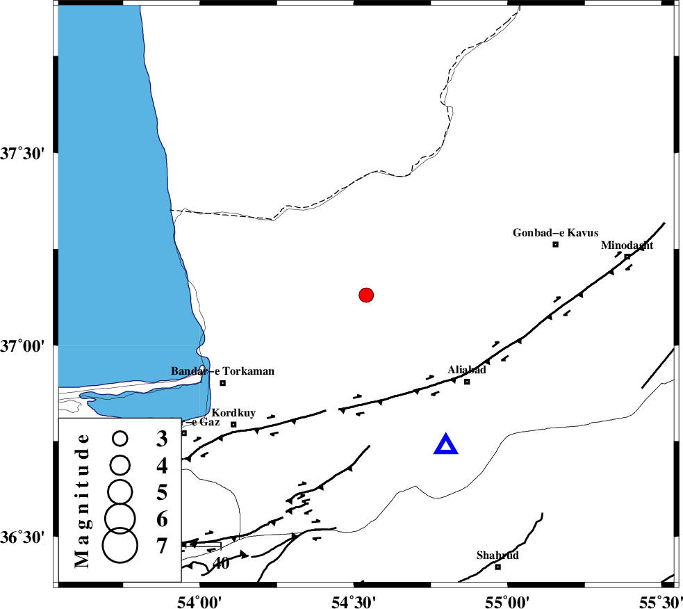
| Date & Time (UTC) | 2009-11-18 17:57:14.2 |
| Date & Time (Local) | 1388/8/27 21:27:14.2 |
| Location | Lat:37.13 Lon: 54.54 |
| Region | Golestan Province, 15 km North of Aq Qaleh |
Nearest Cities |
|
| 13 km North of Qanqarmeh, Golestan Province | |
| 15 km North of Aq Qaleh, Golestan Province | |
| 18 km North of Nodeh malek, Golestan Province | |
| 18 km North West of Gariduji, Golestan Province | |
| 31 km North East of Banavar, Golestan Province | |
| Depth | 15 km |
| Agency | |
Faults within 150 km: |
|
| KHAZAR_F (Length: 523 km) , Distance to epicenter: 31 km | |
| N_ALBORZ_F (Length: 360 km) , Distance to epicenter: 59 km | |
| SHAVAR_F (Length: 87 km) , Distance to epicenter: 64 km | |
| Number of Phases | 3 |
| RMS | 0 |
| Number of Stations | 3 |
| Error in Latitude | >2.6 km |
| Error in Longitude | 2.2 km |
| Error in Depth | 0 km |
Download waveform in seisan format
to download seisan software Click here
to access information about IIEES stations Click here
Amplitude | ||||||||
| UID | Agency | Station | Component | Amplitude | Period | Arrival Time | Proccessing Time | Signal Clip |
| 59338 | IIEES | MRVT | N | 140 | 0.29 | 2009-11-18 17:57:59 | 2010-02-08 11:55:00 | n |
| 59339 | IIEES | DAMV | N | 81 | 0.72 | 2009-11-18 17:58:38 | 2010-02-08 11:55:00 | n |
| 59340 | IIEES | DAMV | E | 107.7 | 1.21 | 2009-11-18 17:58:39 | 2010-02-08 11:55:00 | n |
Phase | ||||||||||||
| Agency | Station | Component | Phase Type | Phase Quality | First Motion | Observed Arrival Time | Time Residual | Loc. Flag | Input Weight | Distance | Azimuth | |
| IIEES | MRVT | Z | Pg | E | 2009-11-18 17:57:39 | 0 | y | 149 | 66 | |||
| IIEES | SHRO | Z | Pg | E | 2009-11-18 17:57:44 | 0 | y | 182 | 133 | |||
| IIEES | DAMV | Z | Pn | E | 2009-11-18 17:57:57 | 0 | y | 284 | 235 | |||