
Magnitude |
2.8 |
| Date & Time (UTC) | 2010-04-15 00:56:20.3 |
| Date & Time (Local) | 1389/1/26 05:26:20.3 |
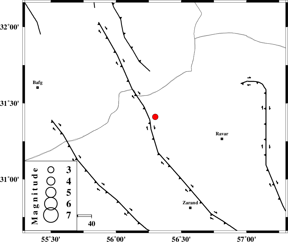
| Location | Lat:31.41 Lon: 56.3 |
| Region | Kerman Province, 51 km North-West of Ravar |
Nearest Cities |
|
| 1 km of Kuhbanan, Kerman Province | |
| 6 km North of Jor, Kerman Province | |
| 30 km South of Asfih, Yazd Province | |
| 31 km East of Basab, Yazd Province | |
| 31 km North West of Toghroljerd, Kerman Province | |
| Depth | 14 km |
| Agency | |
Faults within 150 km: |
|
| KUHBANAN_F (Length: 189 km) , Distance to epicenter: 4 km | |
| JAFARABAD_F (Length: 60 km) , Distance to epicenter: 33 km | |
| DARIVAN_F (Length: 131 km) , Distance to epicenter: 65 km | |
| Number of Phases | 5 |
| RMS | 0.1 |
| Number of Stations | 3 |
| Error in Latitude | >2.8 km |
| Error in Longitude | 3.4 km |
| Error in Depth | 6.9 km |
Download waveform in seisan format
to download seisan software Click here
to access information about IIEES stations Click here
Amplitude | ||||||||
| UID | Agency | Station | Component | Amplitude | Period | Arrival Time | Proccessing Time | Signal Clip |
| 60490 | IIEES | KRBR | N | 97.6 | 0.24 | 2010-04-15 00:57:12 | 2010-04-15 01:15:00 | n |
| 60491 | IIEES | KRBR | E | 150 | 0.28 | 2010-04-15 00:57:13 | 2010-04-15 01:15:00 | n |
Phase | ||||||||||||
| Agency | Station | Component | Phase Type | Phase Quality | First Motion | Observed Arrival Time | Time Residual | Loc. Flag | Input Weight | Distance | Azimuth | |
| IIEES | KRBR | Z | Pg | E | 2010-04-15 00:56:47 | -0.1 | y | 164 | 164 | |||
| IIEES | KRBR | N | Sg | E | 2010-04-15 00:57:07 | 0.1 | y | 164 | 164 | |||
| IIEES | TABS | Z | P | E | 2010-04-15 00:57:00 | 0 | y | 260 | 17 | |||
| IIEES | NASN | Z | Pn | E | 2010-04-15 00:57:13 | 0.1 | y | 364 | 296 | |||
| IIEES | NASN | N | Sg | E | 2010-04-15 00:58:02 | 0 | y | 364 | 296 | |||