
Magnitude |
3 |
| Date & Time (UTC) | 2010-07-31 09:34:19.3 |
| Date & Time (Local) | 1389/5/9 14:04:19.3 |
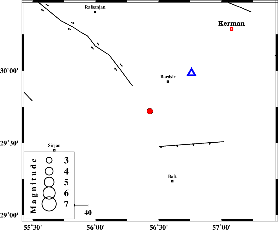
| Location | Lat:29.72 Lon: 56.43 |
| Region | Kerman Province, 26 km South-West of Bardsir |
Nearest Cities |
|
| 14 km East of Tekyeh, Kerman Province | |
| 27 km South West of Bardsir, Kerman Province | |
| 27 km South of Mahutak, Kerman Province | |
| 29 km North of Amirabad, Kerman Province | |
| 31 km South West of Dashtkar, Kerman Province | |
| Depth | 15 km |
| Agency | |
Faults within 150 km: |
|
| RAFSANJAN_F (Length: 129 km) , Distance to epicenter: 23 km | |
| LALEHZAR_F (Length: 52 km) , Distance to epicenter: 28 km | |
| DARIVAN_F (Length: 131 km) , Distance to epicenter: 87 km | |
| Number of Phases | 5 |
| RMS | 0.1 |
| Number of Stations | 3 |
| Error in Latitude | >4.3 km |
| Error in Longitude | 9.2 km |
| Error in Depth | 4.6 km |
Download waveform in seisan format
to download seisan software Click here
to access information about IIEES stations Click here
Amplitude | ||||||||
| UID | Agency | Station | Component | Amplitude | Period | Arrival Time | Proccessing Time | Signal Clip |
| 67250 | IIEES | KRBR | E | 1374.8 | 0.29 | 2010-07-31 09:34:36 | 2010-07-31 09:57:00 | n |
| 67251 | IIEES | BNDS | E | 82.4 | 0.61 | 2010-07-31 09:35:33 | 2010-07-31 09:57:00 | n |
Phase | ||||||||||||
| Agency | Station | Component | Phase Type | Phase Quality | First Motion | Observed Arrival Time | Time Residual | Loc. Flag | Input Weight | Distance | Azimuth | |
| IIEES | KRBR | Z | Pg | E | 2010-07-31 09:34:27 | 0.1 | y | 42.9 | 47 | |||
| IIEES | KRBR | N | Sg | E | 2010-07-31 09:34:33 | -0.1 | y | 42.9 | 47 | |||
| IIEES | BNDS | Z | Pg | E | 2010-07-31 09:35:01 | -0.1 | y | 259 | 186 | |||
| IIEES | BNDS | E | Sg | E | 2010-07-31 09:35:32 | 0.1 | y | 259 | 186 | |||
| IIEES | ZHSF | Z | Pn | E | 2010-07-31 09:35:19 | 0 | y | 421 | 91 | |||