
Magnitude |
3 |
| Date & Time (UTC) | 2010-07-31 12:03:57.0 |
| Date & Time (Local) | 1389/5/9 16:33:57.0 |
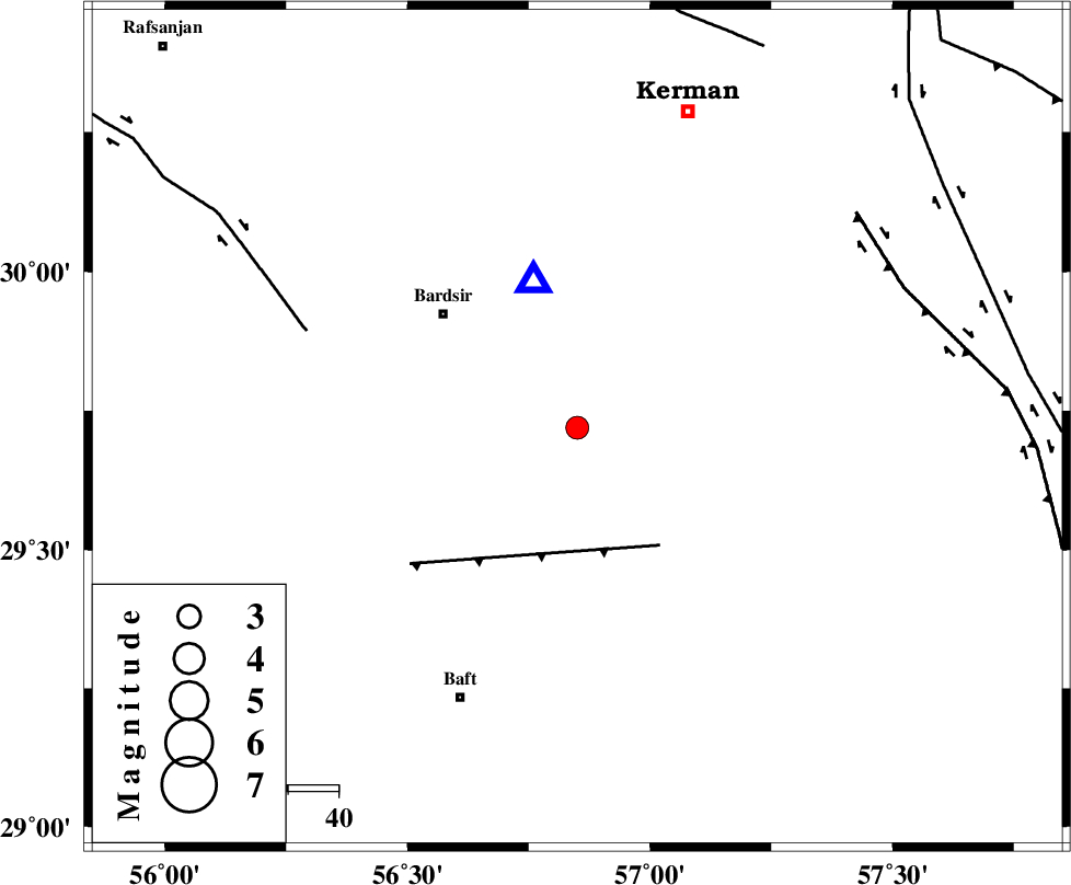
| Location | Lat:29.72 Lon: 56.85 |
| Region | Kerman Province, 35 km South-East of Bardsir |
Nearest Cities |
|
| 16 km South of Negar, Kerman Province | |
| 23 km North of Lalehzar, Kerman Province | |
| 27 km South East of Dashtkar, Kerman Province | |
| 28 km North East of Ghale-ye asgar, Kerman Province | |
| 35 km South East of Bardsir, Kerman Province | |
| Depth | 43 km |
| Agency | |
Faults within 150 km: |
|
| LALEHZAR_F (Length: 52 km) , Distance to epicenter: 29 km | |
| RAFSANJAN_F (Length: 129 km) , Distance to epicenter: 57 km | |
| GOWK_F (Length: 152 km) , Distance to epicenter: 70 km | |
| Number of Phases | 5 |
| RMS | 0.1 |
| Number of Stations | 3 |
| Error in Latitude | >1.8 km |
| Error in Longitude | 8 km |
| Error in Depth | 2.3 km |
Download waveform in seisan format
to download seisan software Click here
to access information about IIEES stations Click here
Amplitude | ||||||||
| UID | Agency | Station | Component | Amplitude | Period | Arrival Time | Proccessing Time | Signal Clip |
| 67290 | IIEES | KRBR | E | 4292.1 | 0.15 | 2010-07-31 12:04:12 | 2010-07-31 12:30:00 | n |
| 67291 | IIEES | KRBR | N | 2692.1 | 0.5 | 2010-07-31 12:04:12 | 2010-07-31 12:30:00 | n |
| 67292 | IIEES | BNDS | N | 62.2 | 1.12 | 2010-07-31 12:05:15 | 2010-07-31 12:30:00 | n |
| 67293 | IIEES | BNDS | E | 63.8 | 0.19 | 2010-07-31 12:05:20 | 2010-07-31 12:30:00 | n |
| 67294 | IIEES | GHIR | E | 11 | 0.52 | 2010-07-31 12:06:05 | 2010-07-31 12:30:00 | n |
| 67295 | IIEES | GHIR | N | 12.3 | 3.77 | 2010-07-31 12:06:06 | 2010-07-31 12:30:00 | n |
Phase | ||||||||||||
| Agency | Station | Component | Phase Type | Phase Quality | First Motion | Observed Arrival Time | Time Residual | Loc. Flag | Input Weight | Distance | Azimuth | |
| IIEES | KRBR | Z | Pg | E | 2010-07-31 12:04:05 | -0.1 | y | 30 | 343 | |||
| IIEES | KRBR | E | Sg | E | 2010-07-31 12:04:12 | 0.1 | y | 30 | 343 | |||
| IIEES | BNDS | Z | Pn | E | 2010-07-31 12:04:35 | 0.1 | y | 266 | 195 | |||
| IIEES | BNDS | N | Sg | E | 2010-07-31 12:05:10 | 0 | y | 266 | 195 | |||
| IIEES | GHIR | Z | Pn | E | 2010-07-31 12:04:52 | 0 | y | 409 | 248 | |||