
Magnitude |
4.7 |
| Date & Time (UTC) | 2010-09-08 12:33:29.5 |
| Date & Time (Local) | 1389/6/17 17:03:29.5 |
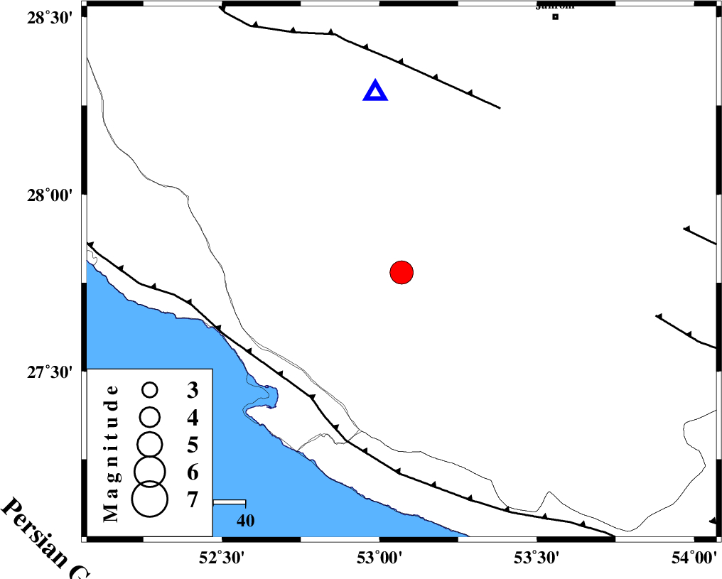
| Location | Lat:27.78 Lon: 53.07 |
| Region | Fars Province, 31 km North-East of Mehr |
Nearest Cities |
|
| 21 km North East of Alamarvdasht, Fars Province | |
| 32 km North East of Mehr, Fars Province | |
| 34 km North East of Ardavan-e olia, Fars Province | |
| 36 km West of Khonj, Fars Province | |
| 38 km North of Khoozi, Fars Province | |
| Depth | 14 km |
| Agency | |
Faults within 150 km: |
|
| MFF3 (Length: 292 km) , Distance to epicenter: 48 km | |
| QIR_F (Length: 130 km) , Distance to epicenter: 60 km | |
| LAR_F (Length: 99 km) , Distance to epicenter: 81 km | |
| Number of Phases | 6 |
| RMS | 0.1 |
| Number of Stations | 4 |
| Error in Latitude | >3.4 km |
| Error in Longitude | 1.8 km |
| Error in Depth | 6.4 km |
Download waveform in seisan format
to download seisan software Click here
to access information about IIEES stations Click here
Amplitude | ||||||||
| UID | Agency | Station | Component | Amplitude | Period | Arrival Time | Proccessing Time | Signal Clip |
| 70090 | IIEES | GHIR | E | 44798.2 | 0.76 | 2010-09-08 12:33:52 | 2010-09-08 01:04:00 | n |
| 70091 | IIEES | GHIR | N | 54863.2 | 0.36 | 2010-09-08 12:33:54 | 2010-09-08 01:04:00 | n |
Phase | ||||||||||||
| Agency | Station | Component | Phase Type | Phase Quality | First Motion | Observed Arrival Time | Time Residual | Loc. Flag | Input Weight | Distance | Azimuth | |
| IIEES | GHIR | Z | Pg | E | 2010-09-08 12:33:39 | -0.1 | y | 57 | 352 | |||
| IIEES | GHIR | E | Sg | E | 2010-09-08 12:33:47 | 0.1 | y | 57 | 352 | |||
| IIEES | AHRM | Z | P | E | 2010-09-08 12:34:03 | 0.1 | y | 212 | 305 | |||
| IIEES | AHRM | N | Sg | E | 2010-09-08 12:34:29 | -0.1 | y | 212 | 305 | |||
| IIEES | BNDS | Z | P | E | 2010-09-08 12:34:15 | 0 | y | 309 | 97 | |||
| IIEES | KRBR | Z | Pn | E | 2010-09-08 12:34:31 | 0 | y | 435 | 55 | |||