
Magnitude |
3.8 |
| Date & Time (UTC) | 2010-12-13 15:00:27.5 |
| Date & Time (Local) | 1389/9/22 18:30:27.5 |
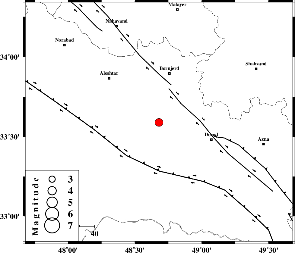
| Location | Lat:33.59 Lon: 48.68 |
| Region | Lorestan Province, 35 km South of Borujerd |
Nearest Cities |
|
| 10 km North of Zagheh, Lorestan Province | |
| 11 km East of Chogolvandi, Lorestan Province | |
| 14 km East of Cheharborji, Lorestan Province | |
| 18 km North West of Razan, Lorestan Province | |
| 20 km South of Pellekan-e sofla, Lorestan Province | |
| Depth | 14 km |
| Agency | |
Faults within 150 km: |
|
| DORUD (Length: 100 km) , Distance to epicenter: 20 km | |
| NAHAVAND_F (Length: 102 km) , Distance to epicenter: 27 km | |
| HZF4 (Length: 492 km) , Distance to epicenter: 32 km | |
| Number of Phases | 5 |
| RMS | 0.1 |
| Number of Stations | 5 |
| Error in Latitude | >4.8 km |
| Error in Longitude | 7.4 km |
| Error in Depth | 9.1 km |
Download waveform in seisan format
to download seisan software Click here
to access information about IIEES stations Click here
Amplitude | ||||||||
| UID | Agency | Station | Component | Amplitude | Period | Arrival Time | Proccessing Time | Signal Clip |
| 75370 | IIEES | ASAO | N | 912.2 | 0.43 | 2010-12-13 15:01:18 | 2010-12-13 03:21:00 | n |
| 75371 | IIEES | SHGR | E | 1618.6 | 0.78 | 2010-12-13 15:01:18 | 2010-12-13 03:21:00 | n |
| 75372 | IIEES | SHGR | N | 1234.4 | 0.39 | 2010-12-13 15:01:19 | 2010-12-13 03:21:00 | n |
| 75373 | IIEES | GHVR | E | 861.9 | 0.63 | 2010-12-13 15:01:43 | 2010-12-13 03:21:00 | n |
| 75374 | IIEES | DAMV | E | 123.1 | 0.33 | 2010-12-13 15:02:21 | 2010-12-13 03:21:00 | n |
| 75375 | IIEES | DAMV | N | 173.5 | 0.77 | 2010-12-13 15:02:27 | 2010-12-13 03:21:00 | n |
Phase | ||||||||||||
| Agency | Station | Component | Phase Type | Phase Quality | First Motion | Observed Arrival Time | Time Residual | Loc. Flag | Input Weight | Distance | Azimuth | |
| IIEES | ASAO | Z | Pg | E | 2010-12-13 15:00:54 | -0.2 | y | 163 | 49 | |||
| IIEES | SHGR | Z | Pg | E | 2010-12-13 15:00:54 | 0 | y | 165 | 176 | |||
| IIEES | GHVR | Z | Pg | E | 2010-12-13 15:01:09 | 0 | y | 257 | 67 | |||
| IIEES | GHVR | N | Sg | E | 2010-12-13 15:01:40 | 0.1 | y | 257 | 67 | |||
| IIEES | CHTH | Z | Pn | E | 2010-12-13 15:01:18 | 0.2 | y | 341 | 40 | |||