
Magnitude |
3.4 |
| Date & Time (UTC) | 2011-02-23 20:30:50.9 |
| Date & Time (Local) | 1389/12/5 00:00:50.9 |
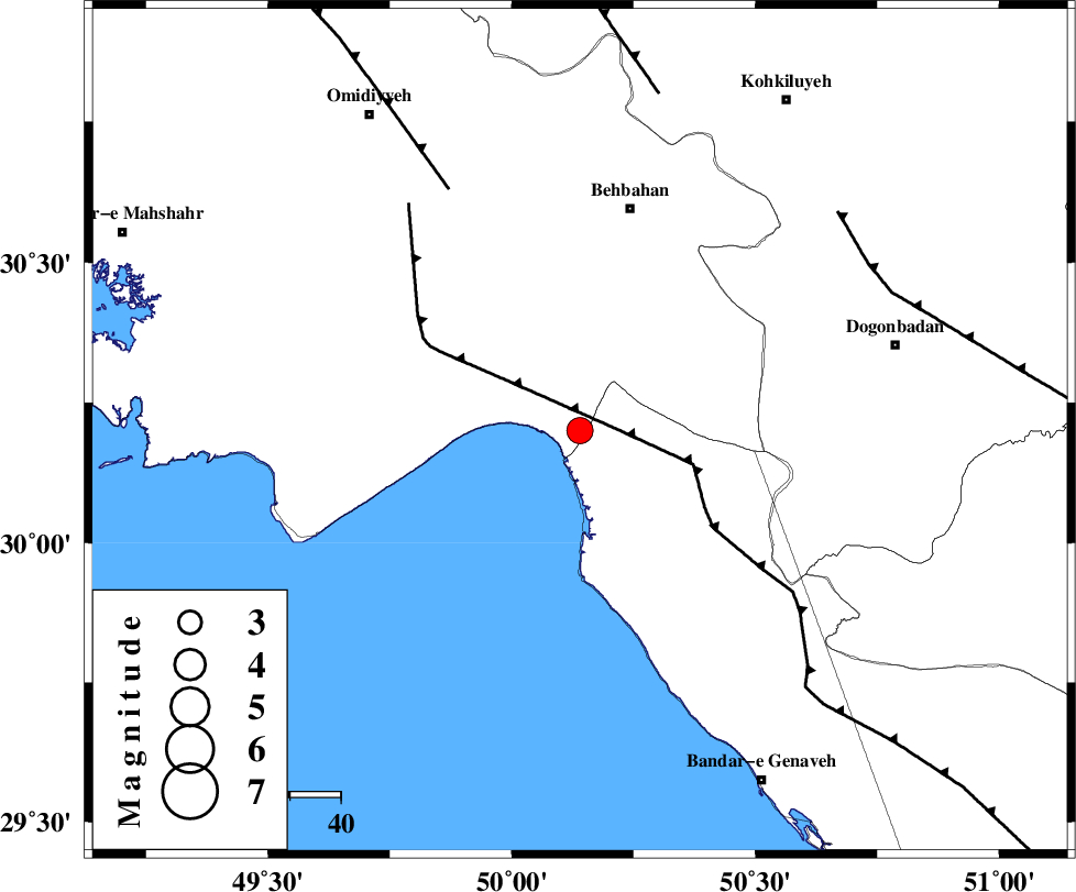
| Location | Lat:30.2 Lon: 50.14 |
| Region | Khoozestan Province, 41 km East of Hendijan |
Nearest Cities |
|
| 6 km North of Ameri, Bushehr Province | |
| 15 km South of Sardasht, Khoozestan Province | |
| 19 km South of Darunak, Khoozestan Province | |
| 24 km North West of Siyahmakan-e bozorg, Bushehr Province | |
| 41 km East of Hendijan, Khoozestan Province | |
| Depth | 14 km |
| Agency | |
Faults within 150 km: |
|
| RAG_E_SEFID_F (Length: 84 km) , Distance to epicenter: 8 km | |
| ZFF3 (Length: 125 km) , Distance to epicenter: 23 km | |
| AGHAJARI_F (Length: 88 km) , Distance to epicenter: 54 km | |
| Number of Phases | 6 |
| RMS | 0.1 |
| Number of Stations | 5 |
| Error in Latitude | >4.7 km |
| Error in Longitude | 7.2 km |
| Error in Depth | 5.9 km |
Download waveform in seisan format
to download seisan software Click here
to access information about IIEES stations Click here
Amplitude | ||||||||
| UID | Agency | Station | Component | Amplitude | Period | Arrival Time | Proccessing Time | Signal Clip |
| 78080 | IIEES | SHGR | N | 465.1 | 0.68 | 2011-02-23 20:32:12 | 2011-02-23 08:56:00 | n |
| 78081 | IIEES | ASAO | N | 28.7 | 0.76 | 2011-02-23 20:33:22 | 2011-02-23 08:56:00 | n |
| 78082 | IIEES | ASAO | E | 29.9 | 0.8 | 2011-02-23 20:33:27 | 2011-02-23 08:56:00 | n |
Phase | ||||||||||||
| Agency | Station | Component | Phase Type | Phase Quality | First Motion | Observed Arrival Time | Time Residual | Loc. Flag | Input Weight | Distance | Azimuth | |
| IIEES | SHGR | Z | P | E | 2011-02-23 20:31:29 | 0.1 | y | 247 | 329 | |||
| IIEES | SHGR | N | Sg | E | 2011-02-23 20:32:00 | -0.1 | y | 247 | 329 | |||
| IIEES | GHIR | Z | P | E | 2011-02-23 20:31:41 | -0.1 | y | 348 | 127 | |||
| IIEES | KHMZ | Z | P | E | 2011-02-23 20:31:47 | 0 | y | 393 | 358 | |||
| IIEES | ASAO | Z | P | E | 2011-02-23 20:31:58 | 0.1 | y | 483 | 359 | |||
| IIEES | SNGE | Z | Pn | E | 2011-02-23 20:32:13 | -0.1 | y | 603 | 335 | |||