
Magnitude |
3.9 |
| Date & Time (UTC) | 2011-04-25 13:49:24.5 |
| Date & Time (Local) | 1390/2/5 18:19:24.5 |
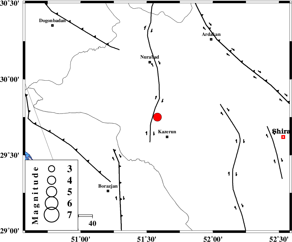
| Location | Lat:29.75 Lon: 51.58 |
| Region | Fars Province, 16 km North of Kazerun |
Nearest Cities |
|
| 7 km of Seyyed hasan, Fars Province | |
| 8 km North of Deris, Fars Province | |
| 13 km West of Nodan, Fars Province | |
| 16 km North of Kazerun, Fars Province | |
| 17 km North East of Kamaraj, Fars Province | |
| Depth | 18 km |
| Agency | |
Faults within 150 km: |
|
| KAZERUN_F (Length: 96 km) , Distance to epicenter: 7 km | |
| BORAZJAN_F (Length: 168 km) , Distance to epicenter: 40 km | |
| KAREBASS_F (Length: 98 km) , Distance to epicenter: 47 km | |
| Number of Phases | 8 |
| RMS | 0.1 |
| Number of Stations | 7 |
| Error in Latitude | >4.1 km |
| Error in Longitude | 3.3 km |
| Error in Depth | 8.7 km |
Download waveform in seisan format
to download seisan software Click here
to access information about IIEES stations Click here
Amplitude | ||||||||
| UID | Agency | Station | Component | Amplitude | Period | Arrival Time | Proccessing Time | Signal Clip |
| 78782 | IIEES | AHRM | E | 3617.7 | 0.37 | 2011-04-25 13:50:01 | 2011-04-25 02:05:00 | n |
| 78783 | IIEES | GHIR | E | 931.7 | 0.79 | 2011-04-25 13:50:38 | 2011-04-25 02:05:00 | n |
| 78784 | IIEES | KRBR | N | 116.9 | 0.97 | 2011-04-25 13:51:33 | 2011-04-25 02:05:00 | n |
| 78785 | IIEES | BNDS | E | 80.5 | 1.13 | 2011-04-25 13:51:40 | 2011-04-25 02:05:00 | n |
Phase | ||||||||||||
| Agency | Station | Component | Phase Type | Phase Quality | First Motion | Observed Arrival Time | Time Residual | Loc. Flag | Input Weight | Distance | Azimuth | |
| IIEES | AHRM | Z | Pg | E | 2011-04-25 13:49:41 | 0 | y | 101 | 196 | |||
| IIEES | GHIR | Z | Pg | E | 2011-04-25 13:49:59 | 0.1 | y | 212 | 139 | |||
| IIEES | GHIR | N | Sg | E | 2011-04-25 13:50:24 | 0 | y | 212 | 139 | |||
| IIEES | NASN | Z | Pn | E | 2011-04-25 13:50:16 | 0.1 | y | 358 | 19 | |||
| IIEES | KHMZ | Z | Pn | E | 2011-04-25 13:50:30 | -0.2 | y | 469 | 341 | |||
| IIEES | KRBR | Z | Pn | E | 2011-04-25 13:50:34 | 0.2 | y | 501 | 86 | |||
| IIEES | BNDS | Z | Pn | E | 2011-04-25 13:50:36 | -0.3 | y | 519 | 119 | |||
| IIEES | SNGE | Z | Pn | E | 2011-04-25 13:51:00 | 0.2 | y | 714 | 327 | |||