
Magnitude |
2.7 |
| Date & Time (UTC) | 2011-07-23 14:37:48.3 |
| Date & Time (Local) | 1390/5/1 19:07:48.3 |
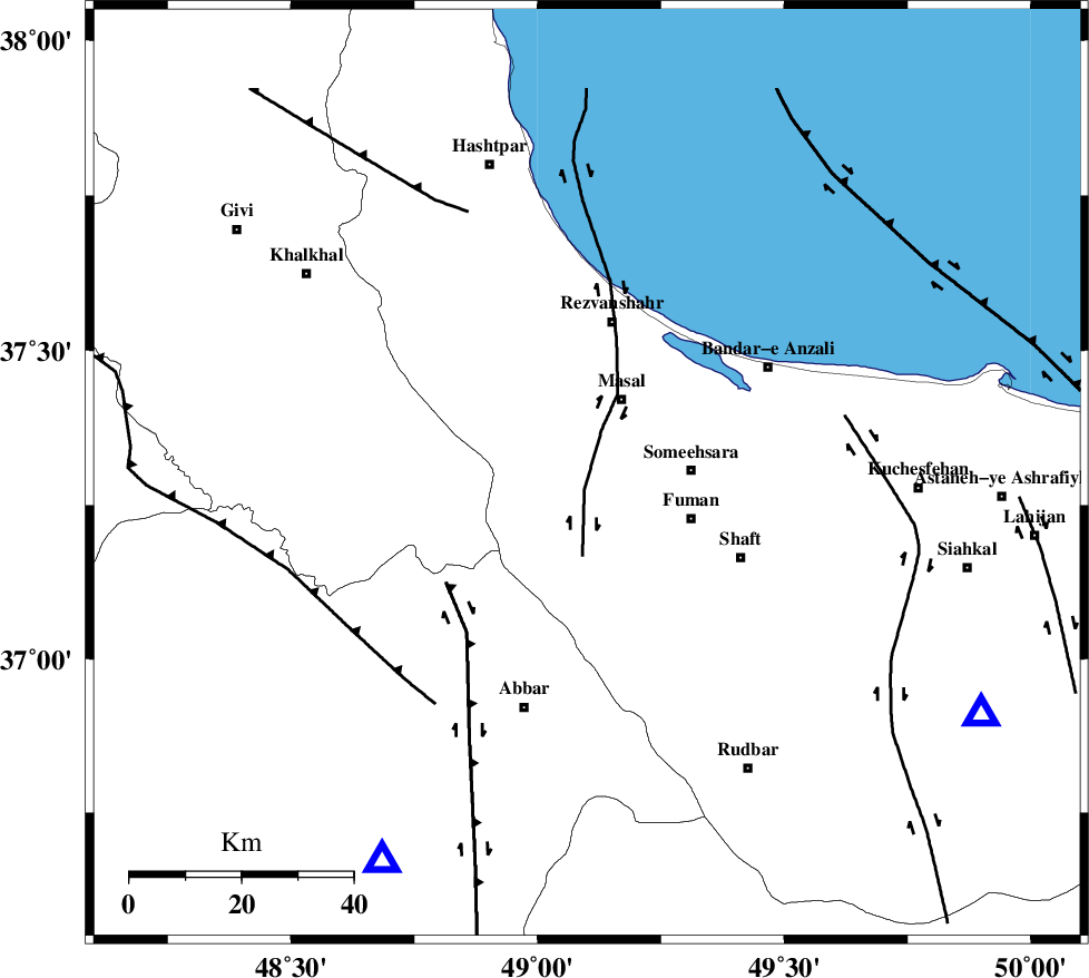
| Location | Lat:37.3 Lon: 49.1 |
| Region | Gilan Province, 14 km South of Masal |
Nearest Cities |
|
| 8 km of Bazarjomeh, Gilan Province | |
| 15 km South of Masal, Gilan Province | |
| 18 km North of Balamakolovan, Gilan Province | |
| 19 km West of Sowmeeh Sara, Gilan Province | |
| 19 km South of Shangavar, Gilan Province | |
| Depth | 14 km |
| Agency | |
Faults within 150 km: |
|
| TALESH_F (Length: 258 km) , Distance to epicenter: 15 km | |
| MASULEL_F (Length: 90 km) , Distance to epicenter: 32 km | |
| RUDBAR_F (Length: 93 km) , Distance to epicenter: 38 km | |
| Number of Phases | 6 |
| RMS | 0.5 |
| Number of Stations | 4 |
| Error in Latitude | >14.7 km |
| Error in Longitude | 6.4 km |
| Error in Depth | 18.6 km |
Download waveform in seisan format
to download seisan software Click here
to access information about IIEES stations Click here
Amplitude | ||||||||
| UID | Agency | Station | Component | Amplitude | Period | Arrival Time | Proccessing Time | Signal Clip |
| 79757 | IIEES | ZNJK | E | 257.9 | 0.17 | 2011-07-23 14:38:12 | 2011-07-23 03:00:00 | n |
| 79758 | IIEES | THKV | E | 80.3 | 0.09 | 2011-07-23 14:38:56 | 2011-07-23 03:00:00 | n |
Phase | ||||||||||||
| Agency | Station | Component | Phase Type | Phase Quality | First Motion | Observed Arrival Time | Time Residual | Loc. Flag | Input Weight | Distance | Azimuth | |
| IIEES | ZNJK | Z | Pg | E | 2011-07-23 14:38:02 | -0.03 | y | 79.5 | 208 | |||
| IIEES | THKV | Z | Pg | E | 2011-07-23 14:38:24 | -0.36 | y | 221 | 134 | |||
| IIEES | CHTH | Z | Pg | E | 2011-07-23 14:38:26 | -0.62 | y | 238 | 130 | |||
| IIEES | CHTH | E | Sg | E | 2011-07-23 14:38:56 | 0.57 | y | 238 | 130 | |||
| IIEES | SNGE | Z | Pn | E | 2011-07-23 14:38:33 | 0.81 | y | 292 | 213 | |||
| IIEES | SNGE | N | Sg | E | 2011-07-23 14:39:10 | -0.33 | y | 292 | 213 | |||