
Magnitude |
2.6 |
| Date & Time (UTC) | 2011-11-29 06:53:05.5 |
| Date & Time (Local) | 1390/9/8 10:23:05.5 |
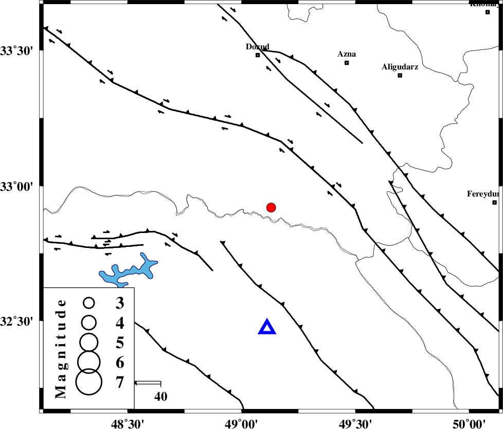
| Location | Lat:32.92 Lon: 49.13 |
| Region | Lorestan Province, 59 km North of Lali |
Nearest Cities |
|
| 23 km South East of Bargsar, Lorestan Province | |
| 30 km South of Shulabad, Lorestan Province | |
| 32 km North West of Parchal, Lorestan Province | |
| 33 km North East of Shuy, Khoozestan Province | |
| 42 km South East of Chamsangar, Lorestan Province | |
| Depth | 15 km |
| Agency | |
Faults within 150 km: |
|
| MFF2 (Length: 205 km) , Distance to epicenter: 25 km | |
| HZF4 (Length: 492 km) , Distance to epicenter: 26 km | |
| BALARUD_F_Z2 (Length: 58 km) , Distance to epicenter: 35 km | |
| Number of Phases | 5 |
| RMS | 0.2 |
| Number of Stations | 6 |
| Error in Latitude | >2.9 km |
| Error in Longitude | 4.3 km |
| Error in Depth | 5.8 km |
Download waveform in seisan format
to download seisan software Click here
to access information about IIEES stations Click here
Amplitude | ||||||||
| UID | Agency | Station | Component | Amplitude | Period | Arrival Time | Proccessing Time | Signal Clip |
| 80823 | IIEES | ASAO | N | 58.6 | 0.56 | 2011-11-29 06:54:12 | 2011-11-29 06:20:00 | n |
| 80824 | IIEES | GHVR | E | 60.1 | 0.61 | 2011-11-29 06:54:28 | 2011-11-29 06:20:00 | n |
| 80825 | IIEES | GHVR | N | 24.6 | 0.75 | 2011-11-29 06:54:32 | 2011-11-29 06:20:00 | n |
| 80826 | IIEES | SNGE | N | 23 | 0.46 | 2011-11-29 06:54:39 | 2011-11-29 06:20:00 | n |
| 80827 | IIEES | NASN | E | 22.2 | 0.38 | 2011-11-29 06:54:49 | 2011-11-29 06:20:00 | n |
Phase | ||||||||||||
| Agency | Station | Component | Phase Type | Phase Quality | First Motion | Observed Arrival Time | Time Residual | Loc. Flag | Input Weight | Distance | Azimuth | |
| IIEES | SHGR | Z | Pg | E | 2011-11-29 06:53:21 | -0.07 | y | 94.9 | 199 | |||
| IIEES | KHMZ | Z | Pg | E | 2011-11-29 06:53:25 | 0.08 | y | 120 | 40 | |||
| IIEES | ASAO | Z | Pn | E | 2011-11-29 06:53:37 | -0.35 | y | 199 | 25 | |||
| IIEES | SNGE | Z | Pn | E | 2011-11-29 06:53:49 | 0.2 | y | 292 | 326 | |||
| IIEES | NASN | Z | Pn | E | 2011-11-29 06:53:56 | 0.17 | y | 345 | 91 | |||