
Magnitude |
3.2 |
| Date & Time (UTC) | 2011-12-10 07:47:19.1 |
| Date & Time (Local) | 1390/9/19 11:17:19.1 |
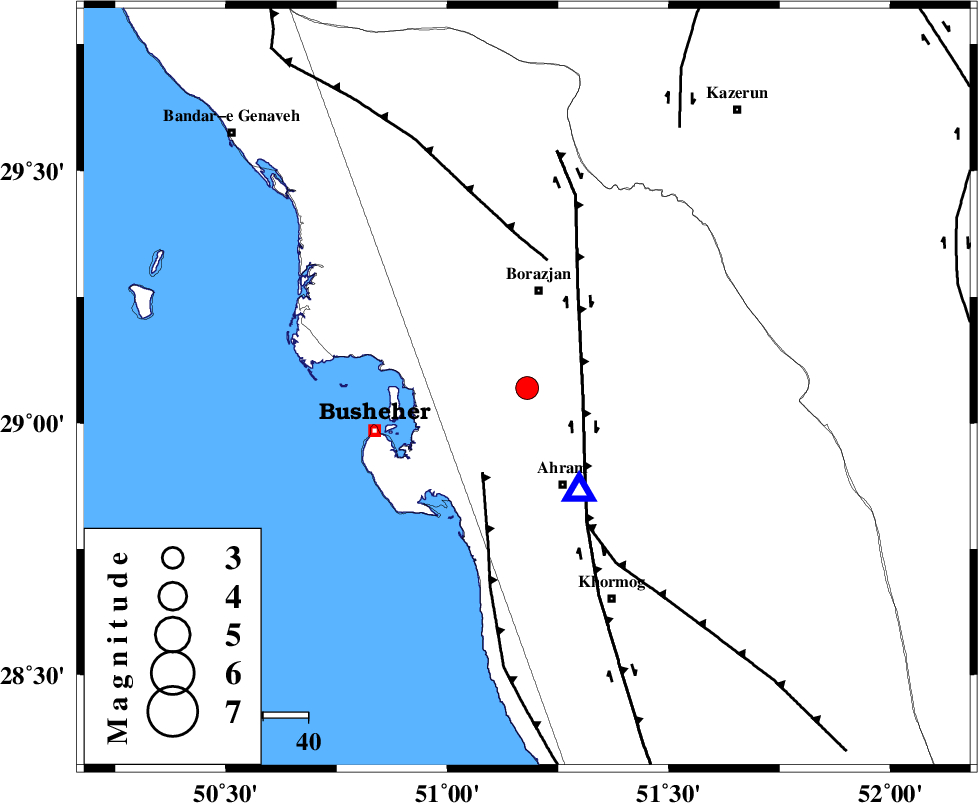
| Location | Lat:29.07 Lon: 51.18 |
| Region | Bushehr Province, 21 km South of Borazjan |
Nearest Cities |
|
| 14 km South of Sarkareh, Bushehr Province | |
| 17 km North of Bazuei, Bushehr Province | |
| 17 km North East of Choghadak, Bushehr Province | |
| 22 km South of Borazjan, Bushehr Province | |
| 23 km North of Ahram, Bushehr Province | |
| Depth | 17 km |
| Agency | |
Faults within 150 km: |
|
| BORAZJAN_F (Length: 168 km) , Distance to epicenter: 13 km | |
| ZFF2 (Length: 84 km) , Distance to epicenter: 21 km | |
| ZFF3 (Length: 125 km) , Distance to epicenter: 28 km | |
| Number of Phases | 4 |
| RMS | 0.2 |
| Number of Stations | 3 |
| Error in Latitude | >2.6 km |
| Error in Longitude | 2.3 km |
| Error in Depth | 0 km |
Download waveform in seisan format
to download seisan software Click here
to access information about IIEES stations Click here
Amplitude | ||||||||
| UID | Agency | Station | Component | Amplitude | Period | Arrival Time | Proccessing Time | Signal Clip |
| 80959 | IIEES | GHIR | E | 218 | 0.57 | 2011-12-10 07:48:18 | 2011-12-10 07:05:00 | n |
| 80960 | IIEES | GHIR | N | 280.7 | 0.73 | 2011-12-10 07:48:25 | 2011-12-10 07:05:00 | n |
Phase | ||||||||||||
| Agency | Station | Component | Phase Type | Phase Quality | First Motion | Observed Arrival Time | Time Residual | Loc. Flag | Input Weight | Distance | Azimuth | |
| IIEES | AHRM | Z | Pg | E | 2011-12-10 07:47:24 | -0.1 | y | 25.8 | 153 | |||
| IIEES | GHIR | Z | Pg | E | 2011-12-10 07:47:51 | 0.3 | y | 197 | 116 | |||
| IIEES | GHIR | N | Sg | E | 2011-12-10 07:48:15 | -0.13 | y | 197 | 116 | |||
| IIEES | NASN | Z | Pn | E | 2011-12-10 07:48:21 | -0.09 | y | 442 | 20 | |||