
Magnitude |
3.7 |
| Date & Time (UTC) | 2012-12-11 21:47:42.6 |
| Date & Time (Local) | 1391/9/22 01:17:42.6 |
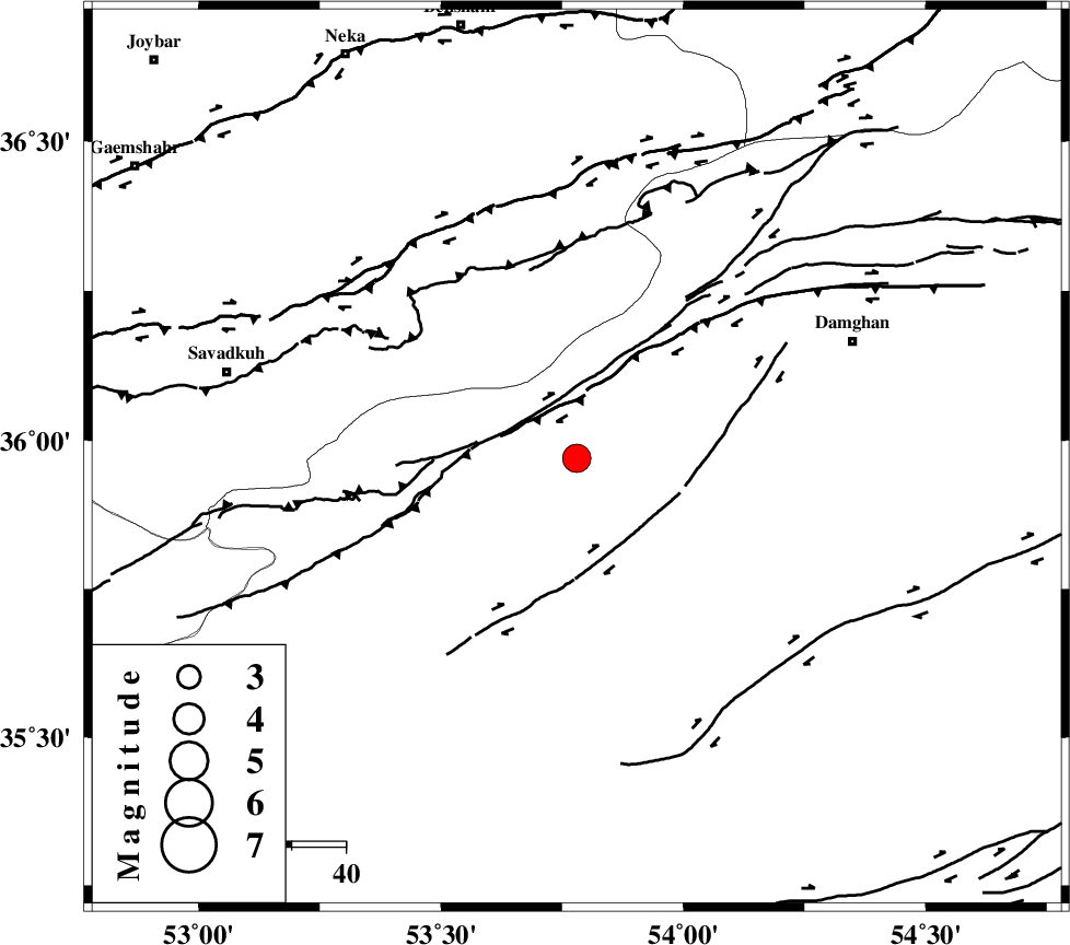
| Location | Lat:35.97 Lon: 53.78 |
| Region | Semnan Province, 56 km South-West of Damghan |
Nearest Cities |
|
| 13 km West of Darvar, Semnan Province | |
| 28 km South of Talma darreh, Mazandaran Province | |
| 34 km West of Amirabad, Semnan Province | |
| 35 km West of Seydabad, Semnan Province | |
| 36 km South East of Kiasar, Mazandaran Province | |
| Depth | 14 km |
| Agency | |
Faults within 150 km: |
|
| ATARI_F (Length: 185 km) , Distance to epicenter: 10 km | |
| DAMGHAN_F (Length: 95 km) , Distance to epicenter: 20 km | |
| ASTANEH_F (Length: 72 km) , Distance to epicenter: 36 km | |
| Number of Phases | 5 |
| RMS | 0.2 |
| Number of Stations | 6 |
| Error in Latitude | >8.7 km |
| Error in Longitude | 3.5 km |
| Error in Depth | 6.4 km |
Download waveform in seisan format
to download seisan software Click here
to access information about IIEES stations Click here
Amplitude | ||||||||
| UID | Agency | Station | Component | Amplitude | Period | Arrival Time | Proccessing Time | Signal Clip |
| 87311 | IIEES | THKV | N | 318.9 | 0.44 | 2012-12-11 21:49:06 | 2012-12-11 10:11:00 | n |
| 87312 | IIEES | GHVR | E | 427.2 | 0.36 | 2012-12-11 21:49:07 | 2012-12-11 10:11:00 | n |
| 87313 | IIEES | GHVR | N | 300.4 | 0.52 | 2012-12-11 21:49:10 | 2012-12-11 10:11:00 | n |
Phase | ||||||||||||
| Agency | Station | Component | Phase Type | Phase Quality | First Motion | Observed Arrival Time | Time Residual | Loc. Flag | Input Weight | Distance | Azimuth | |
| IIEES | SHRO | Z | Pg | E | 2012-12-11 21:48:15 | 0.09 | y | 202 | 88 | |||
| IIEES | CHTH | Z | Pg | E | 2012-12-11 21:48:21 | -0.14 | y | 239 | 269 | |||
| IIEES | THKV | Z | Pn | E | 2012-12-11 21:48:23 | 0.41 | y | 262 | 270 | |||
| IIEES | MRVT | Z | Pn | E | 2012-12-11 21:48:24 | -0.14 | y | 279 | 47 | |||
| IIEES | ASAO | Z | Pn | E | 2012-12-11 21:48:36 | -0.26 | y | 376 | 246 | |||