
Magnitude |
2.9 |
| Date & Time (UTC) | 2012-12-15 03:25:52.4 |
| Date & Time (Local) | 1391/9/25 06:55:52.4 |
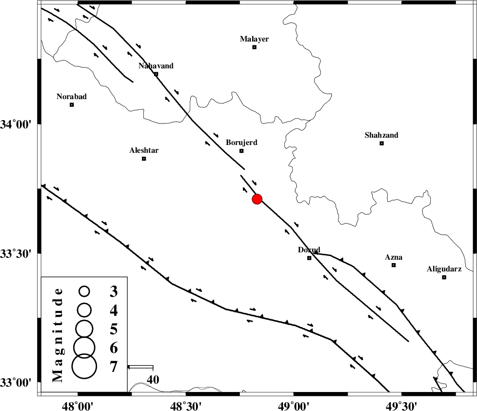
| Location | Lat:33.71 Lon: 48.83 |
| Region | Lorestan Province, 22 km South of Borujerd |
Nearest Cities |
|
| 7 km North of Chalanchulan, Lorestan Province | |
| 14 km South of Hemmatabad, Lorestan Province | |
| 16 km North West of Kagheh, Lorestan Province | |
| 16 km North of Razan, Lorestan Province | |
| 17 km South of Valanjerd, Lorestan Province | |
| Depth | 14 km |
| Agency | |
Faults within 150 km: |
|
| DORUD (Length: 100 km) , Distance to epicenter: 1 km | |
| NAHAVAND_F (Length: 102 km) , Distance to epicenter: 14 km | |
| MAIN_ZAGROS_R_F (Length: 1106 km) , Distance to epicenter: 34 km | |
| Number of Phases | 4 |
| RMS | 0.1 |
| Number of Stations | 4 |
| Error in Latitude | >8.6 km |
| Error in Longitude | 8.3 km |
| Error in Depth | 9.3 km |
Download waveform in seisan format
to download seisan software Click here
to access information about IIEES stations Click here
Amplitude | ||||||||
| UID | Agency | Station | Component | Amplitude | Period | Arrival Time | Proccessing Time | Signal Clip |
| 87345 | IIEES | SHGR | N | 260.8 | 0.48 | 2012-12-15 03:26:52 | 2012-12-15 04:10:00 | n |
| 87346 | IIEES | SHGR | E | 96.6 | 0.44 | 2012-12-15 03:26:57 | 2012-12-15 04:10:00 | n |
Phase | ||||||||||||
| Agency | Station | Component | Phase Type | Phase Quality | First Motion | Observed Arrival Time | Time Residual | Loc. Flag | Input Weight | Distance | Azimuth | |
| IIEES | KHMZ | Z | Pg | E | 2012-12-15 03:26:10 | 0.04 | y | 105 | 88 | |||
| IIEES | ASAO | Z | Pn | E | 2012-12-15 03:26:18 | 0.05 | y | 144 | 50 | |||
| IIEES | GHVR | Z | Pg | E | 2012-12-15 03:26:31 | -0.1 | y | 239 | 68 | |||
| IIEES | GHVR | E | Sg | E | 2012-12-15 03:27:00 | 0.02 | y | 239 | 68 | |||