
Magnitude |
2.9 |
| Date & Time (UTC) | 2013-01-17 01:11:03.7 |
| Date & Time (Local) | 1391/10/28 04:41:03.7 |
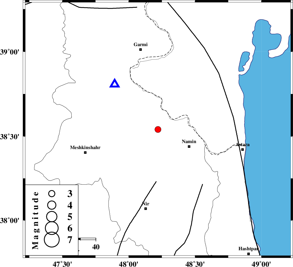
| Location | Lat:38.54 Lon: 48.22 |
| Region | Ardebil Province, 23 km West of Namin |
Nearest Cities |
|
| 9 km North of Taqi dizaj, Ardebil Province | |
| 12 km West of Lurun, Ardebil Province | |
| 18 km South East of Razi, Ardebil Province | |
| 19 km North West of Khaneh zeinian, Ardebil Province | |
| 22 km North West of Anbaran, Ardebil Province | |
| Depth | 18 km |
| Agency | |
Faults within 150 km: |
|
| BOZQUSH (Length: 70 km) , Distance to epicenter: 34 km | |
| SANGAVAR_F (Length: 61 km) , Distance to epicenter: 46 km | |
| TALESH_F (Length: 258 km) , Distance to epicenter: 50 km | |
| Number of Phases | 5 |
| RMS | 0.2 |
| Number of Stations | 3 |
| Error in Latitude | >2.9 km |
| Error in Longitude | 4.9 km |
| Error in Depth | 4 km |
Download waveform in seisan format
to download seisan software Click here
to access information about IIEES stations Click here
Amplitude | ||||||||
| UID | Agency | Station | Component | Amplitude | Period | Arrival Time | Proccessing Time | Signal Clip |
| 87640 | IIEES | GRMI | E | 1342.5 | 0.2 | 2013-01-17 01:11:19 | 2013-01-17 03:42:00 | n |
| 87641 | IIEES | GRMI | N | 1015.5 | 0.2 | 2013-01-17 01:11:19 | 2013-01-17 03:42:00 | n |
Phase | ||||||||||||
| Agency | Station | Component | Phase Type | Phase Quality | First Motion | Observed Arrival Time | Time Residual | Loc. Flag | Input Weight | Distance | Azimuth | |
| IIEES | GRMI | Z | Pg | E | 2013-01-17 01:11:11 | 0.1 | y | 41.5 | 317 | |||
| IIEES | ZNJK | Z | Pn | E | 2013-01-17 01:11:37 | -0.25 | y | 211 | 169 | |||
| IIEES | ZNJK | E | Sg | E | 2013-01-17 01:12:03 | 0.14 | y | 211 | 169 | |||
| IIEES | MAKU | Z | Pn | E | 2013-01-17 01:11:51 | 0.15 | y | 320 | 288 | |||
| IIEES | MAKU | N | Sg | E | 2013-01-17 01:12:33 | -0.14 | y | 320 | 288 | |||