
Magnitude |
2.3 |
| Date & Time (UTC) | 2013-02-07 16:26:30.0 |
| Date & Time (Local) | 1391/11/19 19:56:30.0 |
| Location | Lat:33.86 Lon: 48.58 |
| Region | Lorestan Province, 17 km West of Borujerd |
Nearest Cities |
|
| 12 km North of Pellekan-e sofla, Lorestan Province | |
| 13 km South of Bon dizeh, Lorestan Province | |
| 17 km West of Borujerd, Lorestan Province | |
| 18 km South of Ashtarinan, Lorestan Province | |
| 20 km North West of Hemmatabad, Lorestan Province | |
| Depth | 29 km |
| Agency | |
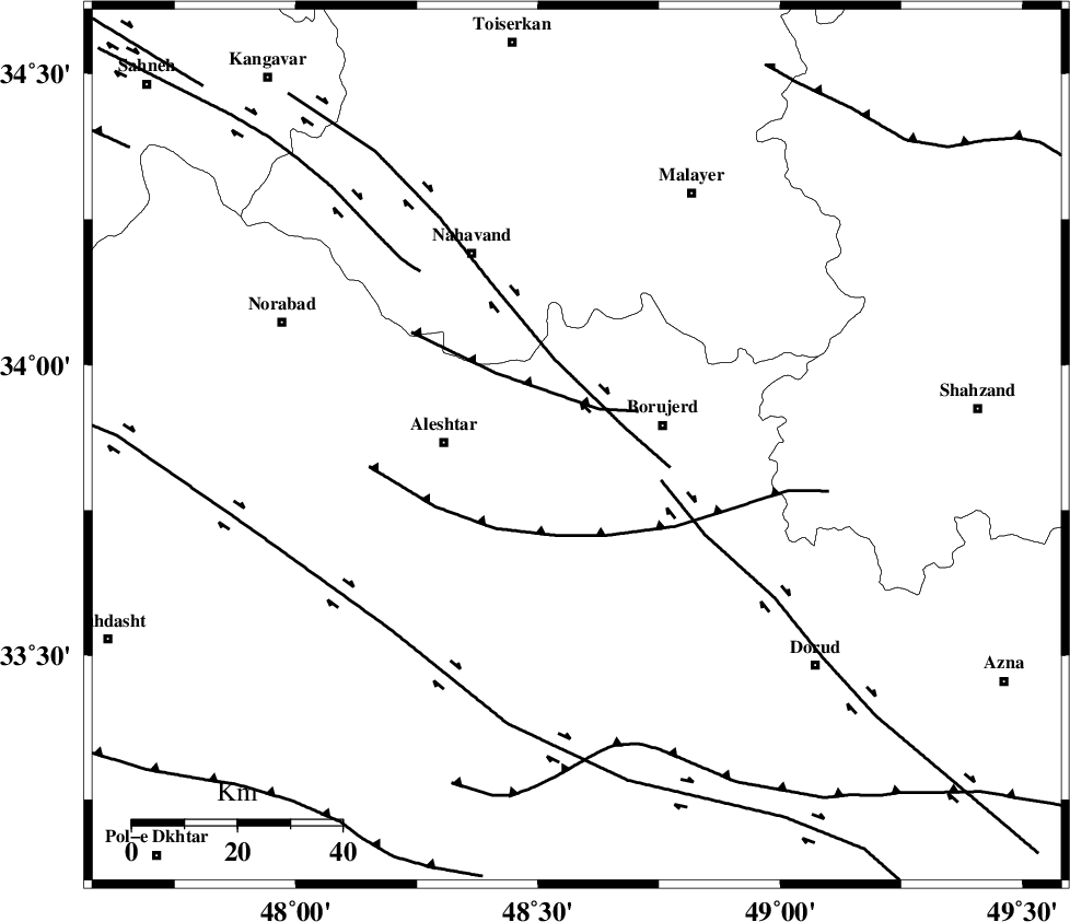
Faults within 150 km: |
|
| NAHAVAND_F (Length: 102 km) , Distance to epicenter: 10 km | |
| DORUD (Length: 100 km) , Distance to epicenter: 17 km | |
| SAHANEH_F (Length: 77 km) , Distance to epicenter: 45 km | |
| Number of Phases | 5 |
| RMS | 0.1 |
| Number of Stations | 3 |
| Error in Latitude | >6.1 km |
| Error in Longitude | 4.3 km |
| Error in Depth | 5.1 km |
Download waveform in seisan format
to download seisan software Click here
to access information about IIEES stations Click here
Amplitude | ||||||||
| UID | Agency | Station | Component | Amplitude | Period | Arrival Time | Proccessing Time | Signal Clip |
| 87820 | IIEES | KHMZ | N | 54.9 | 0.52 | 2013-02-07 16:27:10 | 2013-02-08 02:02:00 | n |
| 87821 | IIEES | KHMZ | E | 56.5 | 0.44 | 2013-02-07 16:27:12 | 2013-02-08 02:02:00 | n |
| 87822 | IIEES | ASAO | E | 44.2 | 0.28 | 2013-02-07 16:27:19 | 2013-02-08 02:02:00 | n |
| 87823 | IIEES | SNGE | N | 32.4 | 0.56 | 2013-02-07 16:27:27 | 2013-02-08 02:02:00 | n |
| 87824 | IIEES | SNGE | E | 34.8 | 0.52 | 2013-02-07 16:27:28 | 2013-02-08 02:02:00 | n |
Phase | ||||||||||||
| Agency | Station | Component | Phase Type | Phase Quality | First Motion | Observed Arrival Time | Time Residual | Loc. Flag | Input Weight | Distance | Azimuth | |
| IIEES | KHMZ | Z | Pg | E | 2013-02-07 16:26:51 | 0.08 | y | 129 | 96 | |||
| IIEES | KHMZ | N | Sg | E | 2013-02-07 16:27:07 | -0.11 | y | 129 | 96 | |||
| IIEES | ASAO | Z | Pg | E | 2013-02-07 16:26:55 | 0.08 | y | 154 | 60 | |||
| IIEES | SNGE | Z | Pn | E | 2013-02-07 16:26:58 | -0.02 | y | 177 | 321 | |||
| IIEES | SNGE | E | Sg | E | 2013-02-07 16:27:19 | -0.03 | y | 177 | 321 | |||