
Magnitude |
4.4 |
| Date & Time (UTC) | 2013-02-19 04:55:48.5 |
| Date & Time (Local) | 1391/12/1 08:25:48.5 |
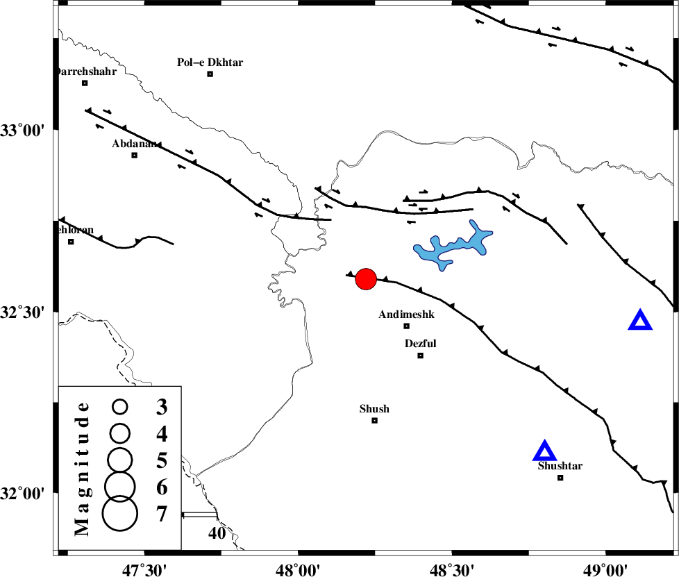
| Location | Lat:32.59 Lon: 48.22 |
| Region | Khoozestan Province, 19 km North-West of Andimeshk |
Nearest Cities |
|
| 10 km of Hoseinieh, Khoozestan Province | |
| 19 km South of Bidruyeh, Khoozestan Province | |
| 19 km North West of Andimeshk, Khoozestan Province | |
| 23 km South West of Sorkhakan, Khoozestan Province | |
| 29 km North West of Dezful, Khoozestan Province | |
| Depth | 16 km |
| Agency | |
Faults within 150 km: |
|
| DEZFUL_EMBAYMENT (Length: 228 km) , Distance to epicenter: 6 km | |
| BALARUD_F_Z1 (Length: 87 km) , Distance to epicenter: 21 km | |
| BALARUD_F_Z3 (Length: 53 km) , Distance to epicenter: 22 km | |
| Number of Phases | 10 |
| RMS | 0.5 |
| Number of Stations | 8 |
| Error in Latitude | >3.9 km |
| Error in Longitude | 6 km |
| Error in Depth | 7.8 km |
Download waveform in seisan format
to download seisan software Click here
to access information about IIEES stations Click here
Amplitude | ||||||||
| UID | Agency | Station | Component | Amplitude | Period | Arrival Time | Proccessing Time | Signal Clip |
| 87962 | IIEES | GHIR | N | 126.4 | 0.33 | 2013-02-19 04:58:26 | 2013-02-19 05:18:00 | n |
Phase | ||||||||||||
| Agency | Station | Component | Phase Type | Phase Quality | First Motion | Observed Arrival Time | Time Residual | Loc. Flag | Input Weight | Distance | Azimuth | |
| IIEES | SHGR | Z | Pg | E | 2013-02-19 04:56:02 | 0.36 | y | 76.4 | 134 | |||
| IIEES | KHMZ | Z | Pn | E | 2013-02-19 04:56:21 | -0.21 | y | 207 | 51 | |||
| IIEES | KHMZ | N | Sg | E | 2013-02-19 04:56:47 | -0.15 | y | 207 | 51 | |||
| IIEES | ASAO | Z | Pn | E | 2013-02-19 04:56:30 | 0.18 | y | 275 | 37 | |||
| IIEES | SNGE | Z | Pn | E | 2013-02-19 04:56:32 | 0.17 | y | 289 | 344 | |||
| IIEES | SNGE | E | Sg | E | 2013-02-19 04:57:09 | -0.24 | y | 289 | 344 | |||
| IIEES | GHVR | Z | P | E | 2013-02-19 04:56:40 | 0.63 | y | 351 | 52 | |||
| IIEES | THKV | Z | Pn | E | 2013-02-19 04:56:51 | -0.18 | y | 443 | 33 | |||
| IIEES | ZNJK | Z | Pn | E | 2013-02-19 04:56:52 | 0.21 | y | 455 | 5 | |||
| IIEES | GHIR | Z | Pn | E | 2013-02-19 04:57:16 | -1.4 | y | 661 | 135 | |||